Alterosa elevation
Alterosa (Minas Gerais), Brazil elevation is 836 meters and Alterosa elevation in feet is 2743 ft above sea level [src 1]. Alterosa is a populated place (feature code) with elevation that is 454 meters (1490 ft) bigger than average city elevation in Brazil.
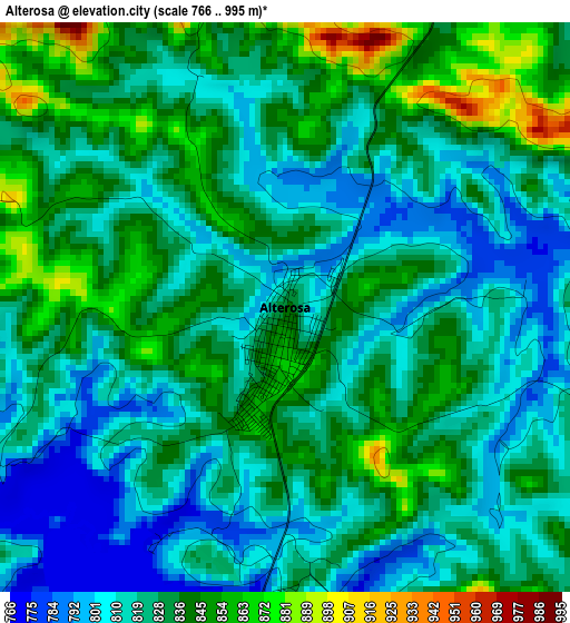
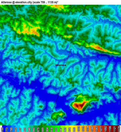
Below is the Elevation map of Alterosa, which displays elevation range with different colors. Scale of the first map is from 766 to 995 m (2513 to 3264 ft) with average elevation of 827.2 meters (=2714 ft) [note 1]
These maps also provides idea of topography and contour of this city, they are displayed at different zoom levels. More info about maps, scale and edge coordinates you can find below images.
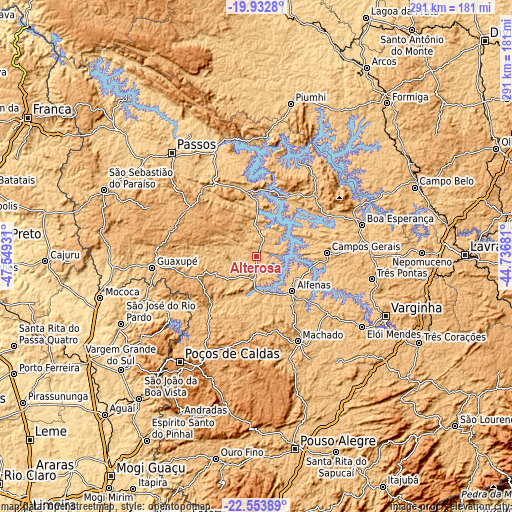
| \ | Map #1 | Map #2 | Topo.Map |
| Scale [m] | 766..995 m | 759..1135 m | × |
| Scale [ft] | 2513..3264 ft | 2490..3724 ft | × |
| Average | 827.2 m = 2714 ft | 834.9 m = 2739 ft | × |
| Width | 9.11 km = 5.7 mi | 18.22 km = 11.3 mi | 291.4 km = 181.1 mi |
| Height | 9.11 km = 5.7 mi | 18.22 km = 11.3 mi | 291.5 km = 181.1 mi |
| ↑Max Latitude | -21.208207° | -21.167232° | -19.9328° |
| Latitude at center | -21.24917° | -21.24917° | -21.24917° |
| ↓Min Latitude | -21.290122° | -21.331062° | -22.55389° |
| ← Min Longitude | -46.187005° | -46.230951° | -47.54931° |
| Longitude center | -46.14306° | -46.14306° | -46.14306° |
| →Max Longitude | -46.099115° | -46.055169° | -44.73681° |
Nearby cities:
Cities around Alterosa sort by population:
• Alfenas elevation 887 m
28.5 km,  134°
134°
• Guaxupé 858 m
59.4 km,  263°
263°
• Machado 815 m
52.7 km,  153°
153°
• Campos Gerais 840 m
39.9 km,  87°
87°
• Muzambinho 1044 m
42 km,  250°
250°
• Paraguaçu 825 m
53.5 km, 128°
• Carmo do Rio Claro 824 m
30.9 km,  4°
4°
• Alpinópolis 877 m
49.8 km,  329°
329°
• Caconde 827 m
60.5 km,  238°
238°
• Campestre 1073 m
52.5 km,  191°
191°
• Botelhos 977 m
50 km,  211°
211°
• Areado 819 m
12.2 km,  181°
181°
Multilingual:
 En español:
Alterosa elevación 836 m.
 En France:
Alterosa élévation 836 m.
 Auf Deutsch:
Alterosa höhe über dem Meeresspiegel ist 836 m.

Sources and notes:
- [note 1] Map square and city borders are not equal. Map elevation data is calculated only from area inside that square.
- [src 1] Elevation data from geonames database provided with same terms of usage.
- [src 2] The elevation map of Alterosa is generated using elevation data from NASA's 3 arcsec (90m) resolution SRTM data.
- [src 3] Base (background) map © OpenStreetMap contributors tiles are generated by Geofabrik and OpenTopoMap.
Copyright & License:
This Alterosa Elevation Map is licensed under CC BY-SA. You may reuse any part from this page, if you give a proper credit by linking to this URL:
 More info on terms of use page.