Caconde elevation
Caconde (São Paulo), Brazil elevation is 827 meters and Caconde elevation in feet is 2713 ft above sea level [src 1]. Caconde is a populated place (feature code) with elevation that is 445 meters (1460 ft) bigger than average city elevation in Brazil.
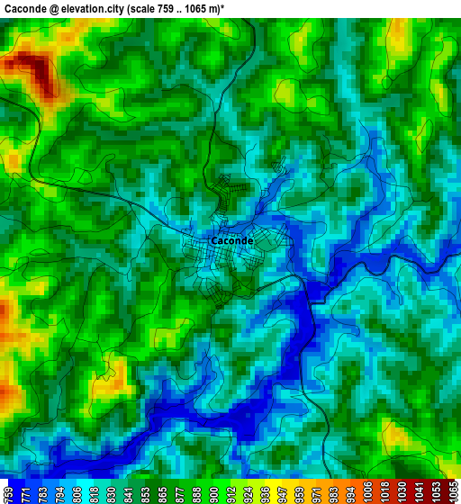
Below is the Elevation map of Caconde, which displays elevation range with different colors. Scale of the first map is from 759 to 1065 m (2490 to 3494 ft) with average elevation of 852.4 meters (=2797 ft) [note 1]
These maps also provides idea of topography and contour of this city, they are displayed at different zoom levels. More info about maps, scale and edge coordinates you can find below images.
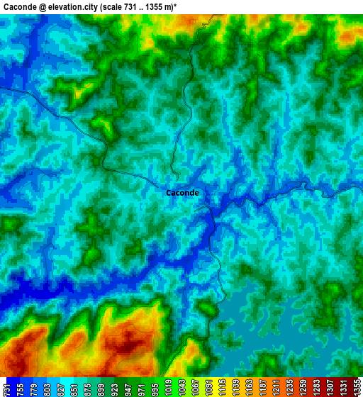
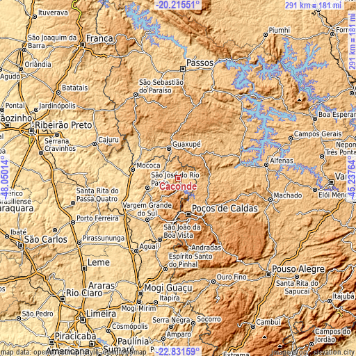
| \ | Map #1 | Map #2 | Topo.Map |
| Scale [m] | 759..1065 m | 731..1355 m | × |
| Scale [ft] | 2490..3494 ft | 2398..4446 ft | × |
| Average | 852.4 m = 2797 ft | 897.8 m = 2946 ft | × |
| Width | 9.09 km = 5.6 mi | 18.18 km = 11.3 mi | 290.9 km = 180.8 mi |
| Height | 9.09 km = 5.6 mi | 18.18 km = 11.3 mi | 290.9 km = 180.8 mi |
| ↑Max Latitude | -21.488555° | -21.447659° | -20.21551° |
| Latitude at center | -21.52944° | -21.52944° | -21.52944° |
| ↓Min Latitude | -21.570313° | -21.611175° | -22.83159° |
| ← Min Longitude | -46.687835° | -46.731781° | -48.05014° |
| Longitude center | -46.64389° | -46.64389° | -46.64389° |
| →Max Longitude | -46.599945° | -46.555999° | -45.23764° |
Nearby cities:
Cities around Caconde sort by population:
• Poços de Caldas elevation 1222 m
30 km,  163°
163°
• São João da Boa Vista 774 m
51.4 km,  198°
198°
• Mococa 617 m
38 km,  280°
280°
• Guaxupé 858 m
25.9 km,  344°
344°
• São José do Rio Pardo 718 m
26.4 km,  253°
253°
• Vargem Grande do Sul 725 m
42.4 km,  217°
217°
• Casa Branca 692 m
53.2 km,  239°
239°
• Guaranésia 782 m
30.4 km,  327°
327°
• Monte Santo de Minas 893 m
51.4 km,  317°
317°
• Muzambinho 1044 m
21 km,  35°
35°
• Campestre 1073 m
45.8 km,  116°
116°
• Botelhos 977 m
28.2 km,  114°
114°
Multilingual:
 En español:
Caconde elevación 827 m.
 En France:
Caconde élévation 827 m.


Sources and notes:
- [note 1] Map square and city borders are not equal. Map elevation data is calculated only from area inside that square.
- [src 1] Elevation data from geonames database provided with same terms of usage.
- [src 2] The elevation map of Caconde is generated using elevation data from NASA's 3 arcsec (90m) resolution SRTM data.
- [src 3] Base (background) map © OpenStreetMap contributors tiles are generated by Geofabrik and OpenTopoMap.
Copyright & License:
This Caconde Elevation Map is licensed under CC BY-SA. You may reuse any part from this page, if you give a proper credit by linking to this URL:
 More info on terms of use page.