Guaranésia elevation
Guaranésia (Minas Gerais), Brazil elevation is 782 meters and Guaranésia elevation in feet is 2566 ft above sea level [src 1]. Guaranésia is a populated place (feature code) with elevation that is 400 meters (1312 ft) bigger than average city elevation in Brazil.
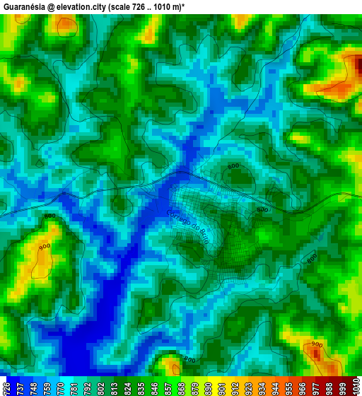
Below is the Elevation map of Guaranésia, which displays elevation range with different colors. Scale of the first map is from 726 to 1010 m (2382 to 3314 ft) with average elevation of 807.9 meters (=2651 ft) [note 1]
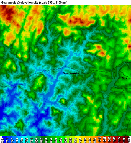
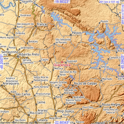
These maps also provides idea of topography and contour of this city, they are displayed at different zoom levels. More info about maps, scale and edge coordinates you can find below images.
| \ | Map #1 | Map #2 | Topo.Map |
| Scale [m] | 726..1010 m | 695..1109 m | × |
| Scale [ft] | 2382..3314 ft | 2280..3638 ft | × |
| Average | 807.9 m = 2651 ft | 842.2 m = 2763 ft | × |
| Width | 9.1 km = 5.7 mi | 18.21 km = 11.3 mi | 291.3 km = 181 mi |
| Height | 9.1 km = 5.7 mi | 18.21 km = 11.3 mi | 291.4 km = 181.1 mi |
| ↑Max Latitude | -21.258221° | -21.21726° | -19.98323° |
| Latitude at center | -21.29917° | -21.29917° | -21.29917° |
| ↓Min Latitude | -21.340108° | -21.381035° | -22.60343° |
| ← Min Longitude | -46.846445° | -46.890391° | -48.20875° |
| Longitude center | -46.8025° | -46.8025° | -46.8025° |
| →Max Longitude | -46.758555° | -46.714609° | -45.39625° |
Nearby cities:
Cities around Guaranésia sort by population:
• Poços de Caldas elevation 1222 m
59.8 km,  155°
155°
• São Sebastião do Paraíso 974 m
46.8 km,  335°
335°
• Mococa 617 m
28.1 km,  228°
228°
• Guaxupé 858 m
9.3 km,  94°
94°
• São José do Rio Pardo 718 m
34.1 km,  195°
195°
• Vargem Grande do Sul 725 m
60 km,  189°
189°
• Casa Branca 692 m
60.4 km,  209°
209°
• Cajuru 786 m
52 km,  272°
272°
• Monte Santo de Minas 893 m
22.1 km,  303°
303°
• Muzambinho 1044 m
29.9 km,  106°
106°
• Caconde 827 m
30.4 km,  147°
147°
• Botelhos 977 m
56.2 km,  131°
131°
Multilingual:
 En español:
Guaranésia elevación 782 m.
 En France:
Guaranésia élévation 782 m.
 Auf Deutsch:
Guaranésia höhe über dem Meeresspiegel ist 782 m.

Sources and notes:
- [note 1] Map square and city borders are not equal. Map elevation data is calculated only from area inside that square.
- [src 1] Elevation data from geonames database provided with same terms of usage.
- [src 2] The elevation map of Guaranésia is generated using elevation data from NASA's 3 arcsec (90m) resolution SRTM data.
- [src 3] Base (background) map © OpenStreetMap contributors tiles are generated by Geofabrik and OpenTopoMap.
Copyright & License:
This Guaranésia Elevation Map is licensed under CC BY-SA. You may reuse any part from this page, if you give a proper credit by linking to this URL:
 More info on terms of use page.