Carmo do Rio Claro elevation
Carmo do Rio Claro (Minas Gerais), Brazil elevation is 824 meters and Carmo do Rio Claro elevation in feet is 2703 ft above sea level [src 1]. Carmo do Rio Claro is a populated place (feature code) with elevation that is 442 meters (1450 ft) bigger than average city elevation in Brazil.
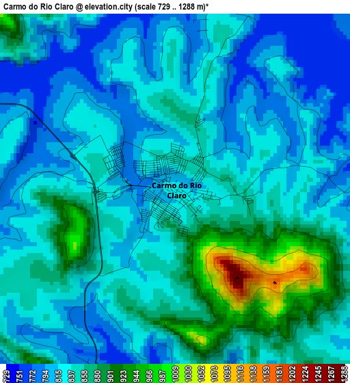
Below is the Elevation map of Carmo do Rio Claro, which displays elevation range with different colors. Scale of the first map is from 729 to 1288 m (2392 to 4226 ft) with average elevation of 839.2 meters (=2753 ft) [note 1]
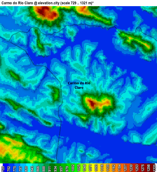
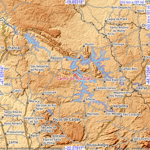
These maps also provides idea of topography and contour of this city, they are displayed at different zoom levels. More info about maps, scale and edge coordinates you can find below images.
| \ | Map #1 | Map #2 | Topo.Map |
| Scale [m] | 729..1288 m | 729..1321 m | × |
| Scale [ft] | 2392..4226 ft | 2392..4334 ft | × |
| Average | 839.2 m = 2753 ft | 830.2 m = 2724 ft | × |
| Width | 9.13 km = 5.7 mi | 18.25 km = 11.3 mi | 292 km = 181.4 mi |
| Height | 9.13 km = 5.7 mi | 18.25 km = 11.3 mi | 292 km = 181.4 mi |
| ↑Max Latitude | -20.9309° | -20.889849° | -19.65318° |
| Latitude at center | -20.97194° | -20.97194° | -20.97194° |
| ↓Min Latitude | -21.012969° | -21.053986° | -22.27917° |
| ← Min Longitude | -46.162835° | -46.206781° | -47.52514° |
| Longitude center | -46.11889° | -46.11889° | -46.11889° |
| →Max Longitude | -46.074945° | -46.030999° | -44.71264° |
Nearby cities:
Cities around Carmo do Rio Claro sort by population:
• Passos elevation 751 m
58.2 km,  298°
298°
• Alfenas 887 m
53.9 km,  160°
160°
• Guaxupé 858 m
71.9 km,  238°
238°
• Boa Esperança 780 m
58.9 km,  102°
102°
• Piuí 791 m
58.8 km,  16°
16°
• Campos Gerais 840 m
47.5 km,  128°
128°
• Muzambinho 1044 m
61.6 km,  223°
223°
• Itaú de Minas 717 m
70.7 km,  291°
291°
• Alpinópolis 877 m
30.4 km, 293°
• Areado 819 m
43.1 km,  183°
183°
• Alterosa 836 m
30.9 km, 184°
• Capitólio 773 m
40.3 km,  10°
10°
Multilingual:
 En español:
Carmo do Rio Claro elevación 824 m.
 En France:
Carmo do Rio Claro élévation 824 m.
 Auf Deutsch:
Carmo do Rio Claro höhe über dem Meeresspiegel ist 824 m.
 На русском:
Carmo do Rio Claro высота над уровнем моря 824 м
Sources and notes:
- [note 1] Map square and city borders are not equal. Map elevation data is calculated only from area inside that square.
- [src 1] Elevation data from geonames database provided with same terms of usage.
- [src 2] The elevation map of Carmo do Rio Claro is generated using elevation data from NASA's 3 arcsec (90m) resolution SRTM data.
- [src 3] Base (background) map © OpenStreetMap contributors tiles are generated by Geofabrik and OpenTopoMap.
Copyright & License:
This Carmo do Rio Claro Elevation Map is licensed under CC BY-SA. You may reuse any part from this page, if you give a proper credit by linking to this URL:
 More info on terms of use page.