Atibaia elevation
Atibaia (São Paulo), Brazil elevation is 817 meters and Atibaia elevation in feet is 2680 ft above sea level [src 1]. Atibaia is a seat of a second-order administrative division (feature code) with elevation that is 435 meters (1427 ft) bigger than average city elevation in Brazil.
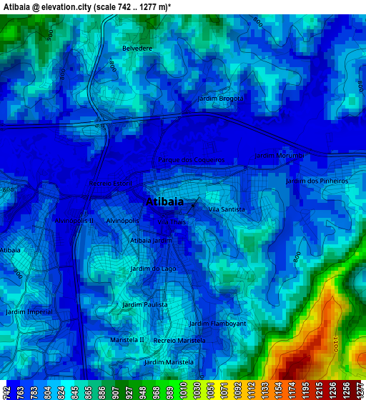
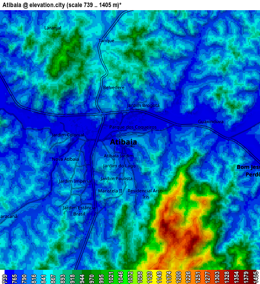
Below is the Elevation map of Atibaia, which displays elevation range with different colors. Scale of the first map is from 742 to 1277 m (2434 to 4190 ft) with average elevation of 814 meters (=2671 ft) [note 1]
These maps also provides idea of topography and contour of this city, they are displayed at different zoom levels. More info about maps, scale and edge coordinates you can find below images.
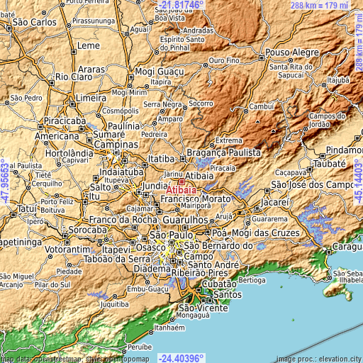
| \ | Map #1 | Map #2 | Topo.Map |
| Scale [m] | 742..1277 m | 739..1405 m | × |
| Scale [ft] | 2434..4190 ft | 2425..4610 ft | × |
| Average | 814 m = 2671 ft | 849.4 m = 2787 ft | × |
| Width | 8.99 km = 5.6 mi | 17.98 km = 11.2 mi | 287.6 km = 178.7 mi |
| Height | 8.99 km = 5.6 mi | 17.98 km = 11.2 mi | 287.6 km = 178.7 mi |
| ↑Max Latitude | -23.076517° | -23.036082° | -21.81746° |
| Latitude at center | -23.11694° | -23.11694° | -23.11694° |
| ↓Min Latitude | -23.157351° | -23.197749° | -24.40396° |
| ← Min Longitude | -46.594225° | -46.638171° | -47.95653° |
| Longitude center | -46.55028° | -46.55028° | -46.55028° |
| →Max Longitude | -46.506335° | -46.462389° | -45.14403° |
Nearby cities:
Cities around Atibaia sort by population:
• Francisco Morato elevation 803 m
27.1 km,  227°
227°
• Bragança Paulista 831 m
18.3 km,  1°
1°
• Várzea Paulista 755 m
30.3 km,  249°
249°
• Franco da Rocha 762 m
29.1 km,  218°
218°
• Caieiras 793 m
33.7 km, 215°
• Itatiba 782 m
32 km,  292°
292°
• Mairiporã 752 m
22.7 km,  189°
189°
• Piracaia 822 m
20.9 km,  70°
70°
• Jarinu 793 m
18.3 km,  275°
275°
• Bom Jesus dos Perdões 788 m
8.9 km,  103°
103°
• Joanópolis 911 m
34.9 km,  53°
53°
• Campo Limpo Paulista 743 m
25.9 km, 247°
Multilingual:
 En español:
Atibaia elevación 817 m.
 En France:
Atibaia élévation 817 m.


Sources and notes:
- [note 1] Map square and city borders are not equal. Map elevation data is calculated only from area inside that square.
- [src 1] Elevation data from geonames database provided with same terms of usage.
- [src 2] The elevation map of Atibaia is generated using elevation data from NASA's 3 arcsec (90m) resolution SRTM data.
- [src 3] Base (background) map © OpenStreetMap contributors tiles are generated by Geofabrik and OpenTopoMap.
Copyright & License:
This Atibaia Elevation Map is licensed under CC BY-SA. You may reuse any part from this page, if you give a proper credit by linking to this URL:
 More info on terms of use page.