Piracaia elevation
Piracaia (São Paulo), Brazil elevation is 822 meters and Piracaia elevation in feet is 2697 ft above sea level [src 1]. Piracaia is a populated place (feature code) with elevation that is 440 meters (1444 ft) bigger than average city elevation in Brazil.
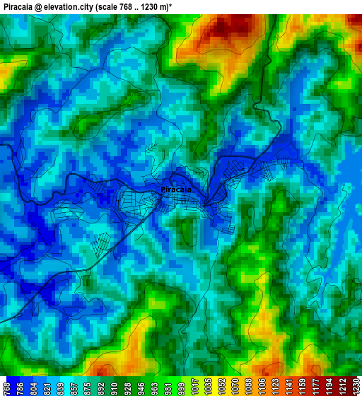
Below is the Elevation map of Piracaia, which displays elevation range with different colors. Scale of the first map is from 768 to 1230 m (2520 to 4035 ft) with average elevation of 887.7 meters (=2912 ft) [note 1]
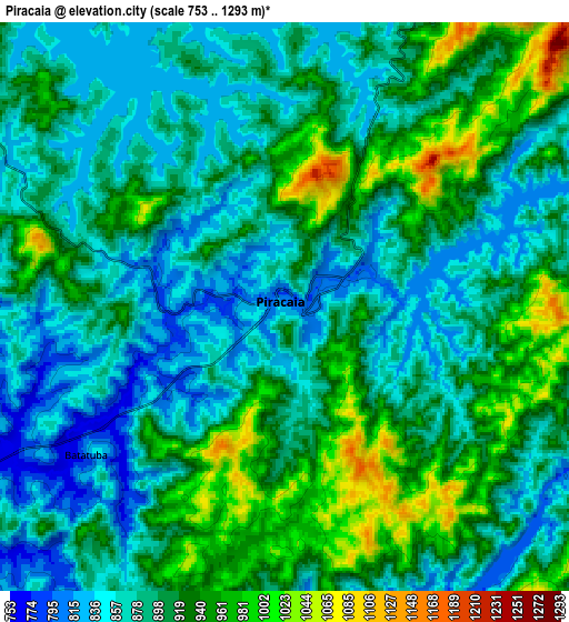
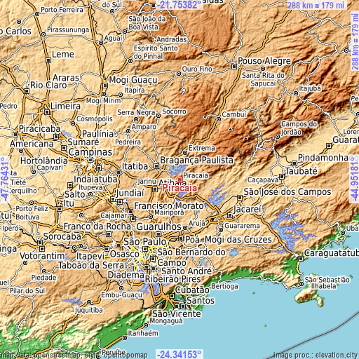
These maps also provides idea of topography and contour of this city, they are displayed at different zoom levels. More info about maps, scale and edge coordinates you can find below images.
| \ | Map #1 | Map #2 | Topo.Map |
| Scale [m] | 768..1230 m | 753..1293 m | × |
| Scale [ft] | 2520..4035 ft | 2470..4242 ft | × |
| Average | 887.7 m = 2912 ft | 904 m = 2966 ft | × |
| Width | 8.99 km = 5.6 mi | 17.98 km = 11.2 mi | 287.7 km = 178.8 mi |
| Height | 8.99 km = 5.6 mi | 17.98 km = 11.2 mi | 287.7 km = 178.8 mi |
| ↑Max Latitude | -23.013448° | -22.972994° | -21.75382° |
| Latitude at center | -23.05389° | -23.05389° | -23.05389° |
| ↓Min Latitude | -23.09432° | -23.134737° | -24.34153° |
| ← Min Longitude | -46.402005° | -46.445951° | -47.76431° |
| Longitude center | -46.35806° | -46.35806° | -46.35806° |
| →Max Longitude | -46.314115° | -46.270169° | -44.95181° |
Nearby cities:
Cities around Piracaia sort by population:
• Bragança Paulista elevation 831 m
22.1 km,  300°
300°
• Atibaia 817 m
20.9 km,  250°
250°
• Arujá 788 m
38.2 km,  174°
174°
• Mairiporã 752 m
37.6 km,  218°
218°
• Santa Isabel 658 m
32.3 km,  154°
154°
• Jarinu 793 m
38.2 km,  262°
262°
• Camanducaia 1012 m
39.7 km,  33°
33°
• Extrema 946 m
22.5 km,  10°
10°
• Bom Jesus dos Perdões 788 m
14.2 km,  230°
230°
• Joanópolis 911 m
16.1 km, 31°
• Monte Verde 1551 m
39.2 km,  57°
57°
• Campo Limpo Paulista 743 m
46.8 km, 248°
Multilingual:
 En español:
Piracaia elevación 822 m.
 En France:
Piracaia élévation 822 m.
 Auf Deutsch:
Piracaia höhe über dem Meeresspiegel ist 822 m.

Sources and notes:
- [note 1] Map square and city borders are not equal. Map elevation data is calculated only from area inside that square.
- [src 1] Elevation data from geonames database provided with same terms of usage.
- [src 2] The elevation map of Piracaia is generated using elevation data from NASA's 3 arcsec (90m) resolution SRTM data.
- [src 3] Base (background) map © OpenStreetMap contributors tiles are generated by Geofabrik and OpenTopoMap.
Copyright & License:
This Piracaia Elevation Map is licensed under CC BY-SA. You may reuse any part from this page, if you give a proper credit by linking to this URL:
 More info on terms of use page.