Várzea Paulista elevation
Várzea Paulista (São Paulo), Brazil elevation is 755 meters and Várzea Paulista elevation in feet is 2477 ft above sea level [src 1]. Várzea Paulista is a populated place (feature code) with elevation that is 373 meters (1224 ft) bigger than average city elevation in Brazil.
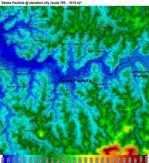
Below is the Elevation map of Várzea Paulista, which displays elevation range with different colors. Scale of the first map is from 709 to 1015 m (2326 to 3330 ft) with average elevation of 780.7 meters (=2561 ft) [note 1]
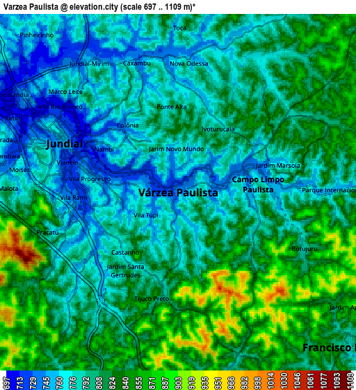
These maps also provides idea of topography and contour of this city, they are displayed at different zoom levels. More info about maps, scale and edge coordinates you can find below images.
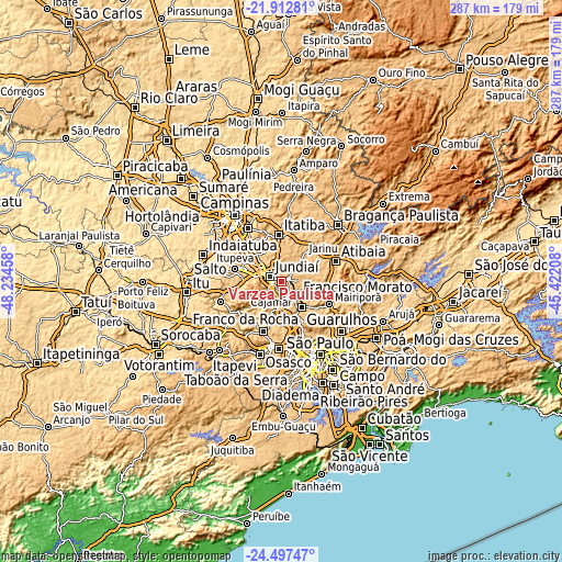
| \ | Map #1 | Map #2 | Topo.Map |
| Scale [m] | 709..1015 m | 697..1109 m | × |
| Scale [ft] | 2326..3330 ft | 2287..3638 ft | × |
| Average | 780.7 m = 2561 ft | 806.5 m = 2646 ft | × |
| Width | 8.98 km = 5.6 mi | 17.96 km = 11.2 mi | 287.4 km = 178.6 mi |
| Height | 8.98 km = 5.6 mi | 17.96 km = 11.2 mi | 287.4 km = 178.6 mi |
| ↑Max Latitude | -23.170996° | -23.130589° | -21.91281° |
| Latitude at center | -23.21139° | -23.21139° | -23.21139° |
| ↓Min Latitude | -23.251772° | -23.292142° | -24.49747° |
| ← Min Longitude | -46.872275° | -46.916221° | -48.23458° |
| Longitude center | -46.82833° | -46.82833° | -46.82833° |
| →Max Longitude | -46.784385° | -46.740439° | -45.42208° |
Nearby cities:
Cities around Várzea Paulista sort by population:
• Jundiaí elevation 753 m
6.3 km,  295°
295°
• Francisco Morato 803 m
11.5 km,  132°
132°
• Franco da Rocha 762 m
16.1 km,  139°
139°
• Caieiras 793 m
19.2 km,  152°
152°
• Itatiba 782 m
22.9 km,  357°
357°
• Cajamar 735 m
16.8 km,  197°
197°
• Vinhedo 733 m
25.2 km,  323°
323°
• Louveira 702 m
18.7 km, 318°
• Itupeva 676 m
24.3 km,  285°
285°
• Jarinu 793 m
15.9 km,  39°
39°
• Pirapora do Bom Jesus 678 m
27.2 km,  220°
220°
• Campo Limpo Paulista 743 m
4.5 km,  82°
82°
Multilingual:
 En español:
Várzea Paulista elevación 755 m.
 En France:
Várzea Paulista élévation 755 m.
 Auf Deutsch:
Várzea Paulista höhe über dem Meeresspiegel ist 755 m.

Sources and notes:
- [note 1] Map square and city borders are not equal. Map elevation data is calculated only from area inside that square.
- [src 1] Elevation data from geonames database provided with same terms of usage.
- [src 2] The elevation map of Várzea Paulista is generated using elevation data from NASA's 3 arcsec (90m) resolution SRTM data.
- [src 3] Base (background) map © OpenStreetMap contributors tiles are generated by Geofabrik and OpenTopoMap.
Copyright & License:
This Várzea Paulista Elevation Map is licensed under CC BY-SA. You may reuse any part from this page, if you give a proper credit by linking to this URL:
 More info on terms of use page.