Bagé elevation
Bagé (Rio Grande do Sul), Brazil elevation is 206 meters and Bagé elevation in feet is 676 ft above sea level [src 1]. Bagé is a populated place (feature code) with elevation that is 176 meters (577 ft) smaller than average city elevation in Brazil.
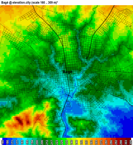
Below is the Elevation map of Bagé, which displays elevation range with different colors. Scale of the first map is from 160 to 309 m (525 to 1014 ft) with average elevation of 218.5 meters (=717 ft) [note 1]
These maps also provides idea of topography and contour of this city, they are displayed at different zoom levels. More info about maps, scale and edge coordinates you can find below images.
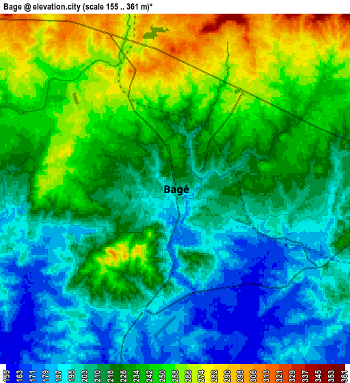
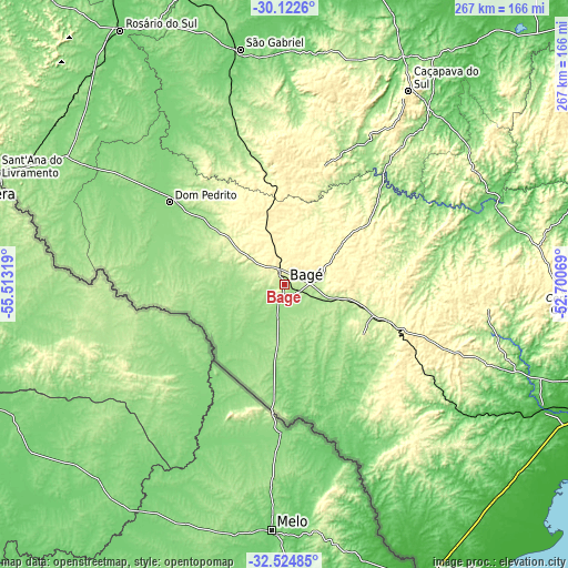
| \ | Map #1 | Map #2 | Topo.Map |
| Scale [m] | 160..309 m | 155..361 m | × |
| Scale [ft] | 525..1014 ft | 509..1184 ft | × |
| Average | 218.5 m = 717 ft | 223.8 m = 734 ft | × |
| Width | 8.35 km = 5.2 mi | 16.69 km = 10.4 mi | 267.1 km = 166 mi |
| Height | 8.35 km = 5.2 mi | 16.69 km = 10.4 mi | 267.1 km = 166 mi |
| ↑Max Latitude | -31.293846° | -31.256286° | -30.1226° |
| Latitude at center | -31.33139° | -31.33139° | -31.33139° |
| ↓Min Latitude | -31.368919° | -31.406434° | -32.52485° |
| ← Min Longitude | -54.150885° | -54.194831° | -55.51319° |
| Longitude center | -54.10694° | -54.10694° | -54.10694° |
| →Max Longitude | -54.062995° | -54.019049° | -52.70069° |
Nearby cities:
Cities around Bagé sort by population:
• Pelotas elevation 6 m
174.3 km,  106°
106°
• Santana do Livramento 213 m
144.3 km,  289°
289°
• São Gabriel 119 m
112.5 km,  349°
349°
• Dom Pedrito 144 m
66.4 km,  305°
305°
• Rosário do Sul 123 m
142.1 km,  327°
327°
• Jaguarão 19 m
153.6 km,  153°
153°
• Canguçu 406 m
136.1 km,  92°
92°
• São Sepé 96 m
140.1 km,  21°
21°
• Herval 283 m
102.2 km,  138°
138°
• Caçapava do Sul 426 m
108.5 km,  33°
33°
• Arroio Grande 31 m
139.4 km, 136°
• Pinheiro Machado 437 m
74.1 km, 111°
Multilingual:
 En español:
Bagé elevación 206 m.
 En France:
Bagé élévation 206 m.


Sources and notes:
- [note 1] Map square and city borders are not equal. Map elevation data is calculated only from area inside that square.
- [src 1] Elevation data from geonames database provided with same terms of usage.
- [src 2] The elevation map of Bagé is generated using elevation data from NASA's 3 arcsec (90m) resolution SRTM data.
- [src 3] Base (background) map © OpenStreetMap contributors tiles are generated by Geofabrik and OpenTopoMap.
Copyright & License:
This Bagé Elevation Map is licensed under CC BY-SA. You may reuse any part from this page, if you give a proper credit by linking to this URL:
 More info on terms of use page.