Canguçu elevation
Canguçu (Rio Grande do Sul), Brazil elevation is 406 meters and Canguçu elevation in feet is 1332 ft above sea level [src 1]. Canguçu is a populated place (feature code) with elevation that is 24 meters (79 ft) bigger than average city elevation in Brazil.
Below is the Elevation map of Canguçu, which displays elevation range with different colors. Scale of the first map is from 268 to 500 m (879 to 1640 ft) with average elevation of 381.9 meters (=1253 ft) [note 1]
These maps also provides idea of topography and contour of this city, they are displayed at different zoom levels. More info about maps, scale and edge coordinates you can find below images.
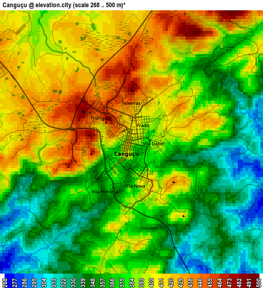
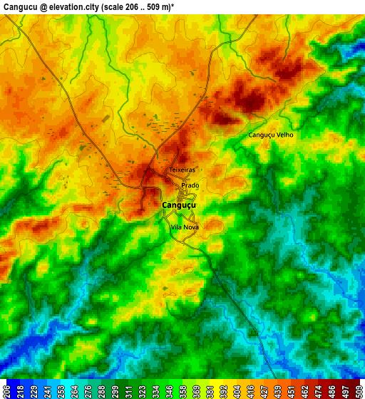
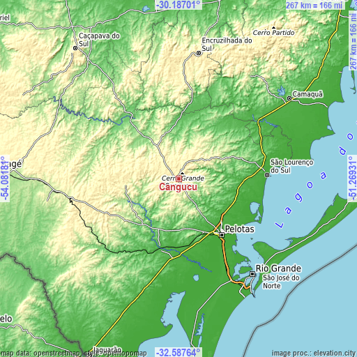
| \ | Map #1 | Map #2 | Topo.Map |
| Scale [m] | 268..500 m | 206..509 m | × |
| Scale [ft] | 879..1640 ft | 676..1670 ft | × |
| Average | 381.9 m = 1253 ft | 356.8 m = 1171 ft | × |
| Width | 8.34 km = 5.2 mi | 16.68 km = 10.4 mi | 266.9 km = 165.8 mi |
| Height | 8.34 km = 5.2 mi | 16.68 km = 10.4 mi | 266.9 km = 165.8 mi |
| ↑Max Latitude | -31.357481° | -31.319947° | -30.18701° |
| Latitude at center | -31.395° | -31.395° | -31.395° |
| ↓Min Latitude | -31.432504° | -31.469993° | -32.58764° |
| ← Min Longitude | -52.719505° | -52.763451° | -54.08181° |
| Longitude center | -52.67556° | -52.67556° | -52.67556° |
| →Max Longitude | -52.631615° | -52.587669° | -51.26931° |
Nearby cities:
Cities around Canguçu sort by population:
• Pelotas elevation 6 m
52.4 km,  142°
142°
• Rio Grande 7 m
89.7 km, 142°
• Bagé 206 m
136.1 km,  272°
272°
• Camaquã 39 m
102 km,  53°
53°
• Jaguarão 19 m
146 km,  206°
206°
• São Lourenço do Sul 13 m
66.3 km,  87°
87°
• Tapes 9 m
146 km,  56°
56°
• Herval 283 m
97.6 km,  224°
224°
• Caçapava do Sul 426 m
124.7 km,  321°
321°
• Encruzilhada do Sul 431 m
95.8 km,  8°
8°
• Arroio Grande 31 m
101.4 km,  202°
202°
• Pinheiro Machado 437 m
69.9 km,  253°
253°
Multilingual:
 En español:
Canguçu elevación 406 m.
 En France:
Canguçu élévation 406 m.


Sources and notes:
- [note 1] Map square and city borders are not equal. Map elevation data is calculated only from area inside that square.
- [src 1] Elevation data from geonames database provided with same terms of usage.
- [src 2] The elevation map of Canguçu is generated using elevation data from NASA's 3 arcsec (90m) resolution SRTM data.
- [src 3] Base (background) map © OpenStreetMap contributors tiles are generated by Geofabrik and OpenTopoMap.
Copyright & License:
This Canguçu Elevation Map is licensed under CC BY-SA. You may reuse any part from this page, if you give a proper credit by linking to this URL:
 More info on terms of use page.