Santana do Livramento elevation
Santana do Livramento (Rio Grande do Sul, Sant'Ana do Livramento), Brazil elevation is 213 meters and Santana do Livramento elevation in feet is 699 ft above sea level [src 1]. Santana do Livramento is a populated place (feature code) with elevation that is 169 meters (554 ft) smaller than average city elevation in Brazil.
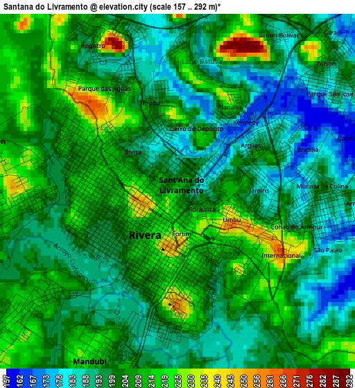
Below is the Elevation map of Santana do Livramento, which displays elevation range with different colors. Scale of the first map is from 157 to 292 m (515 to 958 ft) with average elevation of 201.8 meters (=662 ft) [note 1]
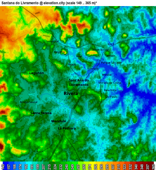
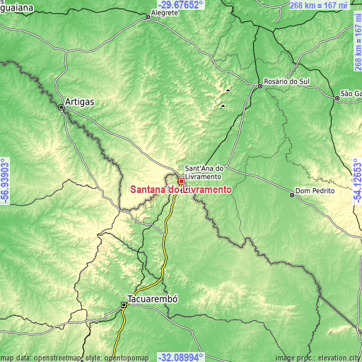
These maps also provides idea of topography and contour of this city, they are displayed at different zoom levels. More info about maps, scale and edge coordinates you can find below images.
| \ | Map #1 | Map #2 | Topo.Map |
| Scale [m] | 157..292 m | 149..365 m | × |
| Scale [ft] | 515..958 ft | 489..1198 ft | × |
| Average | 201.8 m = 662 ft | 216.2 m = 709 ft | × |
| Width | 8.39 km = 5.2 mi | 16.77 km = 10.4 mi | 268.3 km = 166.7 mi |
| Height | 8.39 km = 5.2 mi | 16.77 km = 10.4 mi | 268.4 km = 166.8 mi |
| ↑Max Latitude | -30.853111° | -30.815377° | -29.67652° |
| Latitude at center | -30.89083° | -30.89083° | -30.89083° |
| ↓Min Latitude | -30.928534° | -30.966223° | -32.08994° |
| ← Min Longitude | -55.576725° | -55.620671° | -56.93903° |
| Longitude center | -55.53278° | -55.53278° | -55.53278° |
| →Max Longitude | -55.488835° | -55.444889° | -54.12653° |
Nearby cities:
Cities around Santana do Livramento sort by population:
• Uruguaiana elevation 79 m
195.6 km,  310°
310°
• Bagé 206 m
144.3 km,  109°
109°
• Alegrete 107 m
125.7 km,  348°
348°
• São Gabriel 119 m
131.4 km,  62°
62°
• Santiago 426 m
199.5 km,  18°
18°
• Dom Pedrito 144 m
82.6 km,  97°
97°
• Rosário do Sul 123 m
91.9 km,  40°
40°
• Quaraí 115 m
104.2 km,  302°
302°
• Caçapava do Sul 426 m
200.2 km,  77°
77°
• São Francisco de Assis 134 m
154 km,  14°
14°
• Cacequi 112 m
131 km,  31°
31°
• São Pedro do Sul 185 m
192 km, 42°
Multilingual:
 En español:
Santana do Livramento elevación 213 m.
 En France:
Santana do Livramento élévation 213 m.
 Auf Deutsch:
Santana do Livramento höhe über dem Meeresspiegel ist 213 m.
 На русском:
Сантана-ду-Ливраменту высота над уровнем моря 213 м
Sources and notes:
- [note 1] Map square and city borders are not equal. Map elevation data is calculated only from area inside that square.
- [src 1] Elevation data from geonames database provided with same terms of usage.
- [src 2] The elevation map of Santana do Livramento is generated using elevation data from NASA's 3 arcsec (90m) resolution SRTM data.
- [src 3] Base (background) map © OpenStreetMap contributors tiles are generated by Geofabrik and OpenTopoMap.
Copyright & License:
This Santana do Livramento Elevation Map is licensed under CC BY-SA. You may reuse any part from this page, if you give a proper credit by linking to this URL:
 More info on terms of use page.