Bandeirantes elevation
Bandeirantes (Paraná), Brazil elevation is 424 meters and Bandeirantes elevation in feet is 1391 ft above sea level [src 1]. Bandeirantes is a populated place (feature code) with elevation that is 42 meters (138 ft) bigger than average city elevation in Brazil.
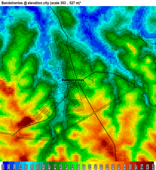
Below is the Elevation map of Bandeirantes, which displays elevation range with different colors. Scale of the first map is from 353 to 527 m (1158 to 1729 ft) with average elevation of 424.1 meters (=1391 ft) [note 1]
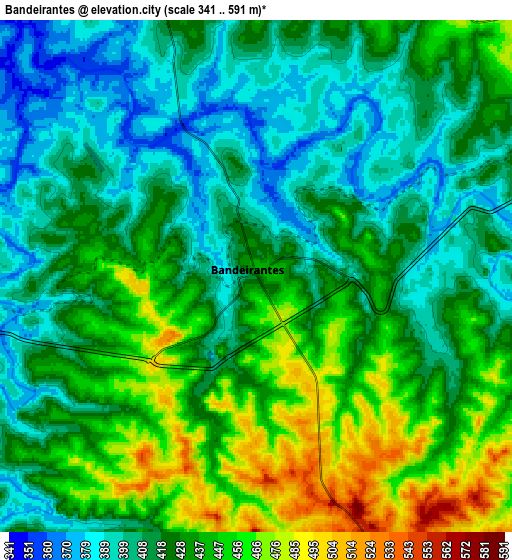
These maps also provides idea of topography and contour of this city, they are displayed at different zoom levels. More info about maps, scale and edge coordinates you can find below images.
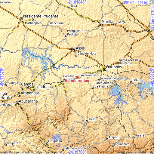
| \ | Map #1 | Map #2 | Topo.Map |
| Scale [m] | 353..527 m | 341..591 m | × |
| Scale [ft] | 1158..1729 ft | 1119..1939 ft | × |
| Average | 424.1 m = 1391 ft | 425.3 m = 1395 ft | × |
| Width | 8.99 km = 5.6 mi | 17.98 km = 11.2 mi | 287.6 km = 178.7 mi |
| Height | 8.99 km = 5.6 mi | 17.98 km = 11.2 mi | 287.6 km = 178.7 mi |
| ↑Max Latitude | -23.069575° | -23.029138° | -21.81046° |
| Latitude at center | -23.11° | -23.11° | -23.11° |
| ↓Min Latitude | -23.150413° | -23.190813° | -24.39708° |
| ← Min Longitude | -50.411445° | -50.455391° | -51.77375° |
| Longitude center | -50.3675° | -50.3675° | -50.3675° |
| →Max Longitude | -50.323555° | -50.279609° | -48.96125° |
Nearby cities:
Cities around Bandeirantes sort by population:
• Assis elevation 560 m
50.1 km,  354°
354°
• Ourinhos 488 m
52.9 km,  74°
74°
• Cornélio Procópio 650 m
29.6 km,  254°
254°
• Santo Antônio da Platina 504 m
36.1 km,  124°
124°
• Jacarezinho 448 m
41.1 km,  97°
97°
• Cândido Mota 483 m
40.5 km,  357°
357°
• Cambará 450 m
30.9 km,  76°
76°
• Palmital 510 m
38.9 km,  23°
23°
• Assaí 572 m
56.6 km,  238°
238°
• Maracaí 392 m
63.5 km,  331°
331°
• Tarumã 452 m
45.8 km, 332°
• Jataizinho 355 m
64.6 km,  255°
255°
Multilingual:
 En español:
Bandeirantes elevación 424 m.
 En France:
Bandeirantes élévation 424 m.
 Auf Deutsch:
Bandeirantes höhe über dem Meeresspiegel ist 424 m.

Sources and notes:
- [note 1] Map square and city borders are not equal. Map elevation data is calculated only from area inside that square.
- [src 1] Elevation data from geonames database provided with same terms of usage.
- [src 2] The elevation map of Bandeirantes is generated using elevation data from NASA's 3 arcsec (90m) resolution SRTM data.
- [src 3] Base (background) map © OpenStreetMap contributors tiles are generated by Geofabrik and OpenTopoMap.
Copyright & License:
This Bandeirantes Elevation Map is licensed under CC BY-SA. You may reuse any part from this page, if you give a proper credit by linking to this URL:
 More info on terms of use page.