Assis elevation
Assis (São Paulo), Brazil elevation is 560 meters and Assis elevation in feet is 1837 ft above sea level [src 1]. Assis is a seat of a second-order administrative division (feature code) with elevation that is 178 meters (584 ft) bigger than average city elevation in Brazil.
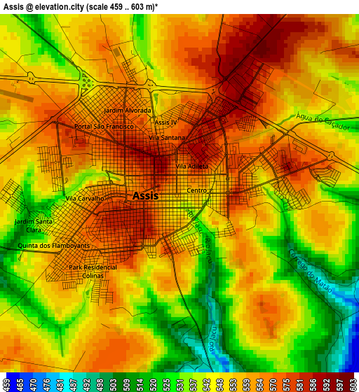
Below is the Elevation map of Assis, which displays elevation range with different colors. Scale of the first map is from 459 to 603 m (1506 to 1978 ft) with average elevation of 551.6 meters (=1810 ft) [note 1]
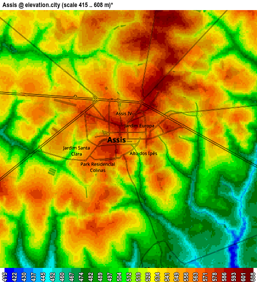
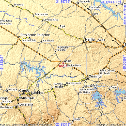
These maps also provides idea of topography and contour of this city, they are displayed at different zoom levels. More info about maps, scale and edge coordinates you can find below images.
| \ | Map #1 | Map #2 | Topo.Map |
| Scale [m] | 459..603 m | 415..608 m | × |
| Scale [ft] | 1506..1978 ft | 1362..1995 ft | × |
| Average | 551.6 m = 1810 ft | 528.4 m = 1734 ft | × |
| Width | 9.02 km = 5.6 mi | 18.04 km = 11.2 mi | 288.6 km = 179.3 mi |
| Height | 9.02 km = 5.6 mi | 18.04 km = 11.2 mi | 288.6 km = 179.3 mi |
| ↑Max Latitude | -22.621111° | -22.580541° | -21.35795° |
| Latitude at center | -22.66167° | -22.66167° | -22.66167° |
| ↓Min Latitude | -22.702217° | -22.742751° | -23.95313° |
| ← Min Longitude | -50.456165° | -50.500111° | -51.81847° |
| Longitude center | -50.41222° | -50.41222° | -50.41222° |
| →Max Longitude | -50.368275° | -50.324329° | -49.00597° |
Nearby cities:
Cities around Assis sort by population:
• Ourinhos elevation 488 m
65.8 km,  122°
122°
• Cornélio Procópio 650 m
62.5 km,  202°
202°
• Paraguaçu Paulista 510 m
32.4 km,  328°
328°
• Bandeirantes 424 m
50.1 km,  174°
174°
• Cândido Mota 483 m
9.8 km,  164°
164°
• Rancharia 521 m
69 km,  314°
314°
• Cambará 450 m
55.1 km,  140°
140°
• Palmital 510 m
24.5 km,  125°
125°
• Pompéia 601 m
66.3 km,  21°
21°
• Maracaí 392 m
26.8 km,  282°
282°
• Quatá 553 m
54.6 km, 327°
• Tarumã 452 m
19.4 km,  240°
240°
Multilingual:
 En español:
Assis elevación 560 m.
 En France:
Assis élévation 560 m.


Sources and notes:
- [note 1] Map square and city borders are not equal. Map elevation data is calculated only from area inside that square.
- [src 1] Elevation data from geonames database provided with same terms of usage.
- [src 2] The elevation map of Assis is generated using elevation data from NASA's 3 arcsec (90m) resolution SRTM data.
- [src 3] Base (background) map © OpenStreetMap contributors tiles are generated by Geofabrik and OpenTopoMap.
Copyright & License:
This Assis Elevation Map is licensed under CC BY-SA. You may reuse any part from this page, if you give a proper credit by linking to this URL:
 More info on terms of use page.