Jataizinho elevation
Jataizinho (Paraná), Brazil elevation is 355 meters and Jataizinho elevation in feet is 1165 ft above sea level [src 1]. Jataizinho is a populated place (feature code) with elevation that is 27 meters (89 ft) smaller than average city elevation in Brazil.
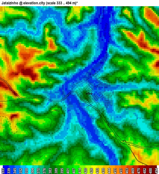
Below is the Elevation map of Jataizinho, which displays elevation range with different colors. Scale of the first map is from 333 to 494 m (1093 to 1621 ft) with average elevation of 386.5 meters (=1268 ft) [note 1]
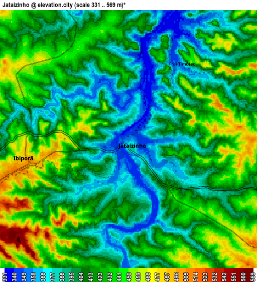
These maps also provides idea of topography and contour of this city, they are displayed at different zoom levels. More info about maps, scale and edge coordinates you can find below images.
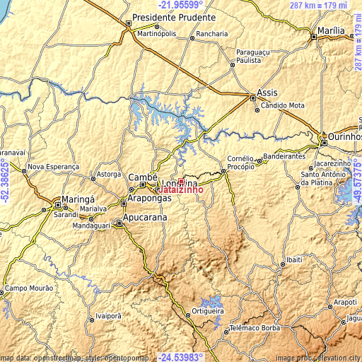
| \ | Map #1 | Map #2 | Topo.Map |
| Scale [m] | 333..494 m | 331..569 m | × |
| Scale [ft] | 1093..1621 ft | 1086..1867 ft | × |
| Average | 386.5 m = 1268 ft | 415.3 m = 1363 ft | × |
| Width | 8.98 km = 5.6 mi | 17.96 km = 11.2 mi | 287.3 km = 178.5 mi |
| Height | 8.98 km = 5.6 mi | 17.96 km = 11.2 mi | 287.3 km = 178.5 mi |
| ↑Max Latitude | -23.213789° | -23.173395° | -21.95599° |
| Latitude at center | -23.25417° | -23.25417° | -23.25417° |
| ↓Min Latitude | -23.294539° | -23.334896° | -24.53983° |
| ← Min Longitude | -51.023945° | -51.067891° | -52.38625° |
| Longitude center | -50.98° | -50.98° | -50.98° |
| →Max Longitude | -50.936055° | -50.892109° | -49.57375° |
Nearby cities:
Cities around Jataizinho sort by population:
• Londrina elevation 605 m
19.7 km,  251°
251°
• Apucarana 871 m
59.1 km,  236°
236°
• Arapongas 805 m
49 km, 247°
• Cambé 668 m
30.6 km,  265°
265°
• Rolândia 736 m
40.2 km,  261°
261°
• Cornélio Procópio 650 m
35 km,  76°
76°
• Ibiporã 500 m
7.1 km, 256°
• Bandeirantes 424 m
64.6 km, 75°
• Bela Vista do Paraíso 633 m
35.8 km,  323°
323°
• Sertanópolis 403 m
22.5 km,  345°
345°
• Florestópolis 528 m
60.2 km, 316°
• Assaí 572 m
19.4 km,  133°
133°
Multilingual:
 En español:
Jataizinho elevación 355 m.
 En France:
Jataizinho élévation 355 m.
 Auf Deutsch:
Jataizinho höhe über dem Meeresspiegel ist 355 m.

Sources and notes:
- [note 1] Map square and city borders are not equal. Map elevation data is calculated only from area inside that square.
- [src 1] Elevation data from geonames database provided with same terms of usage.
- [src 2] The elevation map of Jataizinho is generated using elevation data from NASA's 3 arcsec (90m) resolution SRTM data.
- [src 3] Base (background) map © OpenStreetMap contributors tiles are generated by Geofabrik and OpenTopoMap.
Copyright & License:
This Jataizinho Elevation Map is licensed under CC BY-SA. You may reuse any part from this page, if you give a proper credit by linking to this URL:
 More info on terms of use page.