Barão de Cocais elevation
Barão de Cocais (Minas Gerais), Brazil elevation is 741 meters and Barão de Cocais elevation in feet is 2431 ft above sea level [src 1]. Barão de Cocais is a populated place (feature code) with elevation that is 359 meters (1178 ft) bigger than average city elevation in Brazil.
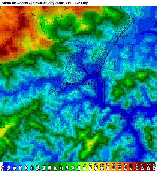
Below is the Elevation map of Barão de Cocais, which displays elevation range with different colors. Scale of the first map is from 719 to 1261 m (2359 to 4137 ft) with average elevation of 860.3 meters (=2823 ft) [note 1]
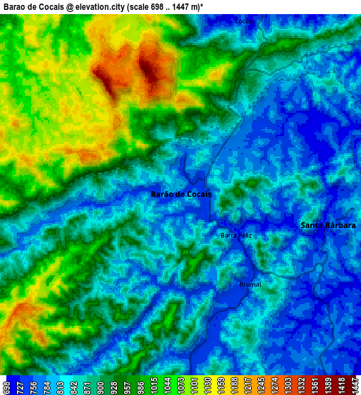
These maps also provides idea of topography and contour of this city, they are displayed at different zoom levels. More info about maps, scale and edge coordinates you can find below images.
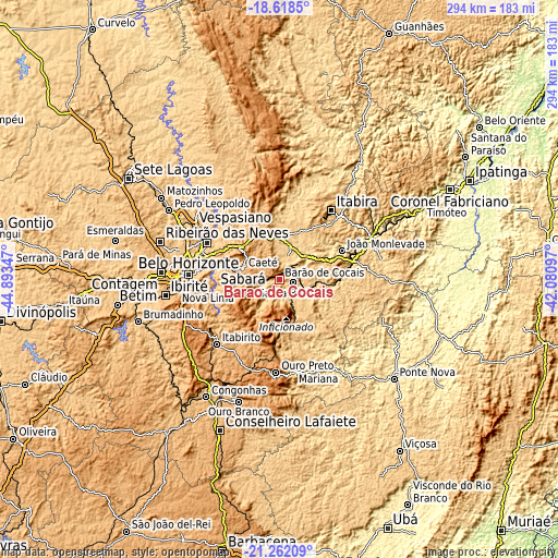
| \ | Map #1 | Map #2 | Topo.Map |
| Scale [m] | 719..1261 m | 698..1447 m | × |
| Scale [ft] | 2359..4137 ft | 2290..4747 ft | × |
| Average | 860.3 m = 2823 ft | 900.9 m = 2956 ft | × |
| Width | 9.19 km = 5.7 mi | 18.37 km = 11.4 mi | 293.9 km = 182.6 mi |
| Height | 9.19 km = 5.7 mi | 18.37 km = 11.4 mi | 294 km = 182.7 mi |
| ↑Max Latitude | -19.904515° | -19.86319° | -18.6185° |
| Latitude at center | -19.94583° | -19.94583° | -19.94583° |
| ↓Min Latitude | -19.987134° | -20.028427° | -21.26209° |
| ← Min Longitude | -43.531165° | -43.575111° | -44.89347° |
| Longitude center | -43.48722° | -43.48722° | -43.48722° |
| →Max Longitude | -43.443275° | -43.399329° | -42.08097° |
Nearby cities:
Cities around Barão de Cocais sort by population:
• Belo Horizonte elevation 872 m
47.2 km,  273°
273°
• Santa Luzia 760 m
42.8 km,  297°
297°
• Itabira 794 m
45.4 km,  36°
36°
• Nova Lima 744 m
37.8 km,  263°
263°
• João Monlevade 742 m
36.1 km,  65°
65°
• Ouro Preto 1201 m
50 km,  182°
182°
• Mariana 707 m
48.6 km,  171°
171°
• Itabirito 852 m
47.4 km,  223°
223°
• Caeté 910 m
20.4 km,  290°
290°
• Raposos 736 m
33.2 km, 265°
• Alvinópolis 602 m
49.2 km,  111°
111°
• Rio Piracicaba 634 m
32.8 km,  86°
86°
Multilingual:
 En español:
Barão de Cocais elevación 741 m.
 En France:
Barão de Cocais élévation 741 m.
 Auf Deutsch:
Barão de Cocais höhe über dem Meeresspiegel ist 741 m.

Sources and notes:
- [note 1] Map square and city borders are not equal. Map elevation data is calculated only from area inside that square.
- [src 1] Elevation data from geonames database provided with same terms of usage.
- [src 2] The elevation map of Barão de Cocais is generated using elevation data from NASA's 3 arcsec (90m) resolution SRTM data.
- [src 3] Base (background) map © OpenStreetMap contributors tiles are generated by Geofabrik and OpenTopoMap.
Copyright & License:
This Barão de Cocais Elevation Map is licensed under CC BY-SA. You may reuse any part from this page, if you give a proper credit by linking to this URL:
 More info on terms of use page.