Itabira elevation
Itabira (Minas Gerais), Brazil elevation is 794 meters and Itabira elevation in feet is 2605 ft above sea level [src 1]. Itabira is a populated place (feature code) with elevation that is 412 meters (1352 ft) bigger than average city elevation in Brazil.
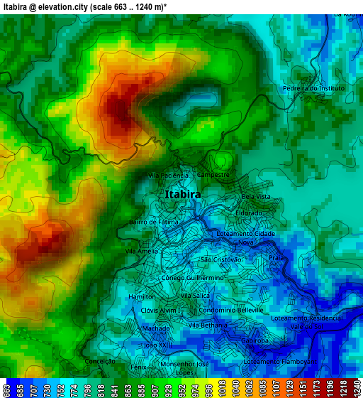
Below is the Elevation map of Itabira, which displays elevation range with different colors. Scale of the first map is from 663 to 1240 m (2175 to 4068 ft) with average elevation of 855.4 meters (=2806 ft) [note 1]
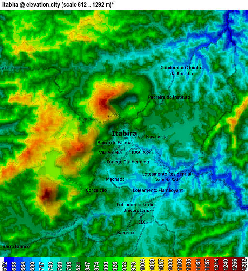
These maps also provides idea of topography and contour of this city, they are displayed at different zoom levels. More info about maps, scale and edge coordinates you can find below images.
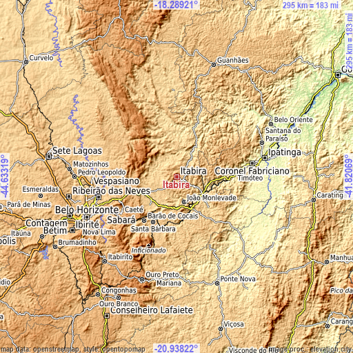
| \ | Map #1 | Map #2 | Topo.Map |
| Scale [m] | 663..1240 m | 612..1292 m | × |
| Scale [ft] | 2175..4068 ft | 2008..4239 ft | × |
| Average | 855.4 m = 2806 ft | 847.9 m = 2782 ft | × |
| Width | 9.21 km = 5.7 mi | 18.41 km = 11.4 mi | 294.5 km = 183 mi |
| Height | 9.21 km = 5.7 mi | 18.41 km = 11.4 mi | 294.6 km = 183.1 mi |
| ↑Max Latitude | -19.577771° | -19.536361° | -18.28921° |
| Latitude at center | -19.61917° | -19.61917° | -19.61917° |
| ↓Min Latitude | -19.660559° | -19.701937° | -20.93822° |
| ← Min Longitude | -43.270885° | -43.314831° | -44.63319° |
| Longitude center | -43.22694° | -43.22694° | -43.22694° |
| →Max Longitude | -43.182995° | -43.139049° | -41.82069° |
Nearby cities:
Cities around Itabira sort by population:
• Santa Luzia elevation 760 m
67.5 km,  255°
255°
• Coronel Fabriciano 239 m
63.6 km,  79°
79°
• Timóteo 356 m
60.6 km,  85°
85°
• João Monlevade 742 m
21.9 km,  165°
165°
• Lagoa Santa 791 m
70.6 km,  269°
269°
• Caeté 910 m
54.7 km,  237°
237°
• Barão de Cocais 741 m
45.4 km,  216°
216°
• Nova Era 632 m
24.6 km,  126°
126°
• Alvinópolis 602 m
57.3 km,  161°
161°
• Conceição do Mato Dentro 708 m
68 km,  342°
342°
• Rio Piracicaba 634 m
34.9 km, 170°
• São Domingos do Prata 589 m
38.5 km,  135°
135°
Multilingual:
 En español:
Itabira elevación 794 m.
 En France:
Itabira élévation 794 m.


Sources and notes:
- [note 1] Map square and city borders are not equal. Map elevation data is calculated only from area inside that square.
- [src 1] Elevation data from geonames database provided with same terms of usage.
- [src 2] The elevation map of Itabira is generated using elevation data from NASA's 3 arcsec (90m) resolution SRTM data.
- [src 3] Base (background) map © OpenStreetMap contributors tiles are generated by Geofabrik and OpenTopoMap.
Copyright & License:
This Itabira Elevation Map is licensed under CC BY-SA. You may reuse any part from this page, if you give a proper credit by linking to this URL:
 More info on terms of use page.