Raposos elevation
Raposos (Minas Gerais), Brazil elevation is 736 meters and Raposos elevation in feet is 2415 ft above sea level [src 1]. Raposos is a populated place (feature code) with elevation that is 354 meters (1161 ft) bigger than average city elevation in Brazil.
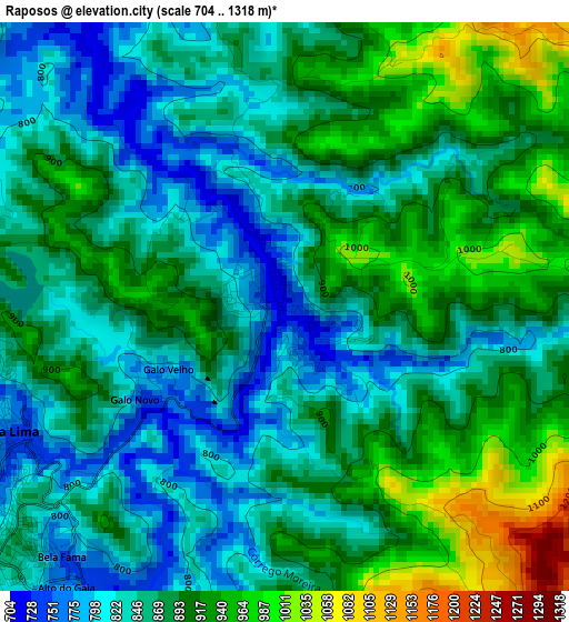
Below is the Elevation map of Raposos, which displays elevation range with different colors. Scale of the first map is from 704 to 1318 m (2310 to 4324 ft) with average elevation of 875.7 meters (=2873 ft) [note 1]
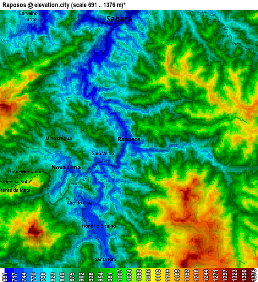
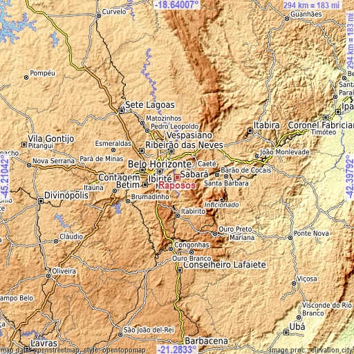
These maps also provides idea of topography and contour of this city, they are displayed at different zoom levels. More info about maps, scale and edge coordinates you can find below images.
| \ | Map #1 | Map #2 | Topo.Map |
| Scale [m] | 704..1318 m | 691..1376 m | × |
| Scale [ft] | 2310..4324 ft | 2267..4514 ft | × |
| Average | 875.7 m = 2873 ft | 932 m = 3058 ft | × |
| Width | 9.19 km = 5.7 mi | 18.37 km = 11.4 mi | 293.9 km = 182.6 mi |
| Height | 9.19 km = 5.7 mi | 18.37 km = 11.4 mi | 293.9 km = 182.6 mi |
| ↑Max Latitude | -19.925911° | -19.884591° | -18.64007° |
| Latitude at center | -19.96722° | -19.96722° | -19.96722° |
| ↓Min Latitude | -20.008518° | -20.049806° | -21.2833° |
| ← Min Longitude | -43.848115° | -43.892061° | -45.21042° |
| Longitude center | -43.80417° | -43.80417° | -43.80417° |
| →Max Longitude | -43.760225° | -43.716279° | -42.39792° |
Nearby cities:
Cities around Raposos sort by population:
• Belo Horizonte elevation 872 m
14.9 km,  290°
290°
• Contagem 945 m
26.4 km,  278°
278°
• Ribeirão das Neves 804 m
37 km,  307°
307°
• Santa Luzia 760 m
22.5 km,  347°
347°
• Ibirité 883 m
27.3 km,  257°
257°
• Vespasiano 689 m
33 km,  337°
337°
• Nova Lima 744 m
4.9 km,  245°
245°
• Itabirito 852 m
31.8 km,  179°
179°
• Lagoa Santa 791 m
38.8 km, 344°
• Caeté 910 m
17.1 km,  55°
55°
• Barão de Cocais 741 m
33.2 km,  85°
85°
• Sarzedo 795 m
36.4 km, 257°
Multilingual:
 En español:
Raposos elevación 736 m.
 En France:
Raposos élévation 736 m.


Sources and notes:
- [note 1] Map square and city borders are not equal. Map elevation data is calculated only from area inside that square.
- [src 1] Elevation data from geonames database provided with same terms of usage.
- [src 2] The elevation map of Raposos is generated using elevation data from NASA's 3 arcsec (90m) resolution SRTM data.
- [src 3] Base (background) map © OpenStreetMap contributors tiles are generated by Geofabrik and OpenTopoMap.
Copyright & License:
This Raposos Elevation Map is licensed under CC BY-SA. You may reuse any part from this page, if you give a proper credit by linking to this URL:
 More info on terms of use page.