Batatais elevation
Batatais (São Paulo), Brazil elevation is 877 meters and Batatais elevation in feet is 2877 ft above sea level [src 1]. Batatais is a populated place (feature code) with elevation that is 495 meters (1624 ft) bigger than average city elevation in Brazil.
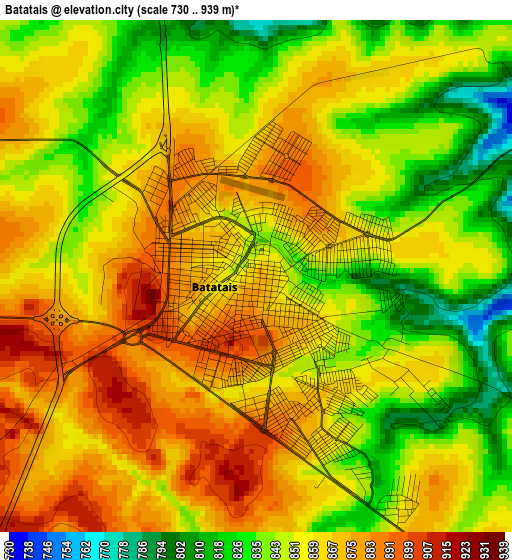
Below is the Elevation map of Batatais, which displays elevation range with different colors. Scale of the first map is from 730 to 939 m (2395 to 3081 ft) with average elevation of 855.4 meters (=2806 ft) [note 1]
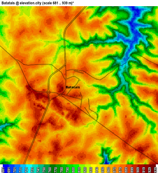
These maps also provides idea of topography and contour of this city, they are displayed at different zoom levels. More info about maps, scale and edge coordinates you can find below images.
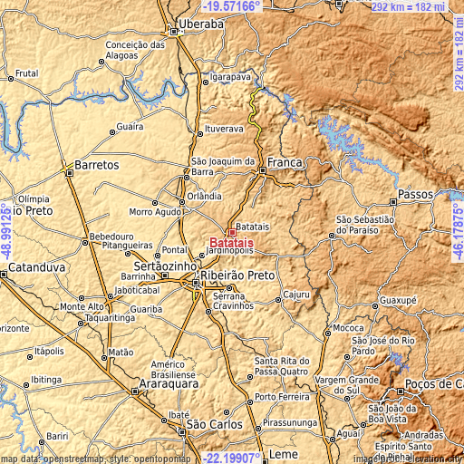
| \ | Map #1 | Map #2 | Topo.Map |
| Scale [m] | 730..939 m | 681..939 m | × |
| Scale [ft] | 2395..3081 ft | 2234..3081 ft | × |
| Average | 855.4 m = 2806 ft | 843.9 m = 2769 ft | × |
| Width | 9.13 km = 5.7 mi | 18.26 km = 11.3 mi | 292.1 km = 181.5 mi |
| Height | 9.13 km = 5.7 mi | 18.26 km = 11.3 mi | 292.2 km = 181.6 mi |
| ↑Max Latitude | -20.850048° | -20.808975° | -19.57166° |
| Latitude at center | -20.89111° | -20.89111° | -20.89111° |
| ↓Min Latitude | -20.932161° | -20.9732° | -22.19907° |
| ← Min Longitude | -47.628945° | -47.672891° | -48.99125° |
| Longitude center | -47.585° | -47.585° | -47.585° |
| →Max Longitude | -47.541055° | -47.497109° | -46.17875° |
Nearby cities:
Cities around Batatais sort by population:
• Ribeirão Preto elevation 554 m
39.5 km,  216°
216°
• Franca 1002 m
43.6 km,  26°
26°
• Sertãozinho 547 m
50.2 km,  236°
236°
• Orlândia 700 m
36.7 km,  301°
301°
• São Joaquim da Barra 623 m
44.4 km,  320°
320°
• Serrana 560 m
35.6 km,  181°
181°
• Jardinópolis 600 m
23.3 km,  232°
232°
• Pontal 531 m
49.2 km,  252°
252°
• Cajuru 786 m
51.7 km,  145°
145°
• Brodósqui 866 m
13.5 km,  214°
214°
• Altinópolis 918 m
26.5 km,  124°
124°
• Nuporanga 783 m
24.9 km, 315°
Multilingual:
 En español:
Batatais elevación 877 m.
 En France:
Batatais élévation 877 m.
 Auf Deutsch:
Batatais höhe über dem Meeresspiegel ist 877 m.

Sources and notes:
- [note 1] Map square and city borders are not equal. Map elevation data is calculated only from area inside that square.
- [src 1] Elevation data from geonames database provided with same terms of usage.
- [src 2] The elevation map of Batatais is generated using elevation data from NASA's 3 arcsec (90m) resolution SRTM data.
- [src 3] Base (background) map © OpenStreetMap contributors tiles are generated by Geofabrik and OpenTopoMap.
Copyright & License:
This Batatais Elevation Map is licensed under CC BY-SA. You may reuse any part from this page, if you give a proper credit by linking to this URL:
 More info on terms of use page.