Serrana elevation
Serrana (São Paulo), Brazil elevation is 560 meters and Serrana elevation in feet is 1837 ft above sea level [src 1]. Serrana is a populated place (feature code) with elevation that is 178 meters (584 ft) bigger than average city elevation in Brazil.
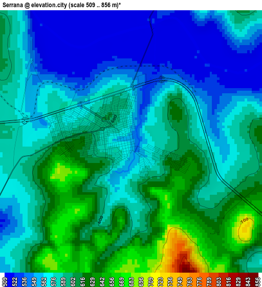
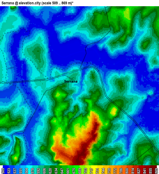
Below is the Elevation map of Serrana, which displays elevation range with different colors. Scale of the first map is from 509 to 856 m (1670 to 2808 ft) with average elevation of 586.7 meters (=1925 ft) [note 1]
These maps also provides idea of topography and contour of this city, they are displayed at different zoom levels. More info about maps, scale and edge coordinates you can find below images.
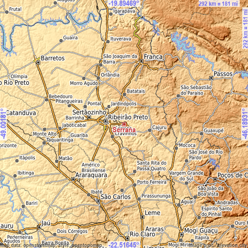
| \ | Map #1 | Map #2 | Topo.Map |
| Scale [m] | 509..856 m | 509..869 m | × |
| Scale [ft] | 1670..2808 ft | 1670..2851 ft | × |
| Average | 586.7 m = 1925 ft | 589.3 m = 1933 ft | × |
| Width | 9.11 km = 5.7 mi | 18.22 km = 11.3 mi | 291.5 km = 181.1 mi |
| Height | 9.11 km = 5.7 mi | 18.22 km = 11.3 mi | 291.5 km = 181.1 mi |
| ↑Max Latitude | -21.170416° | -21.129431° | -19.89469° |
| Latitude at center | -21.21139° | -21.21139° | -21.21139° |
| ↓Min Latitude | -21.252352° | -21.293303° | -22.51645° |
| ← Min Longitude | -47.639505° | -47.683451° | -49.00181° |
| Longitude center | -47.59556° | -47.59556° | -47.59556° |
| →Max Longitude | -47.551615° | -47.507669° | -46.18931° |
Nearby cities:
Cities around Serrana sort by population:
• Ribeirão Preto elevation 554 m
22.6 km,  279°
279°
• Sertãozinho 547 m
41.7 km, 281°
• Batatais 877 m
35.6 km,  1°
1°
• Jardinópolis 600 m
27.7 km,  320°
320°
• Cravinhos 801 m
19.9 km,  224°
224°
• Pontal 531 m
50.4 km,  294°
294°
• Santa Rosa de Viterbo 677 m
37.7 km,  140°
140°
• Cajuru 786 m
31 km,  103°
103°
• Brodósqui 866 m
25.3 km,  345°
345°
• Altinópolis 918 m
30.9 km,  48°
48°
• Pradópolis 539 m
51.4 km,  251°
251°
• São Simão 659 m
30.1 km,  171°
171°
Multilingual:
 En español:
Serrana elevación 560 m.
 En France:
Serrana élévation 560 m.


Sources and notes:
- [note 1] Map square and city borders are not equal. Map elevation data is calculated only from area inside that square.
- [src 1] Elevation data from geonames database provided with same terms of usage.
- [src 2] The elevation map of Serrana is generated using elevation data from NASA's 3 arcsec (90m) resolution SRTM data.
- [src 3] Base (background) map © OpenStreetMap contributors tiles are generated by Geofabrik and OpenTopoMap.
Copyright & License:
This Serrana Elevation Map is licensed under CC BY-SA. You may reuse any part from this page, if you give a proper credit by linking to this URL:
 More info on terms of use page.