Bauru elevation
Bauru (São Paulo), Brazil elevation is 530 meters and Bauru elevation in feet is 1739 ft above sea level [src 1]. Bauru is a seat of a second-order administrative division (feature code) with elevation that is 148 meters (486 ft) bigger than average city elevation in Brazil.
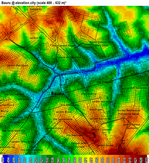
Below is the Elevation map of Bauru, which displays elevation range with different colors. Scale of the first map is from 488 to 632 m (1601 to 2073 ft) with average elevation of 558.7 meters (=1833 ft) [note 1]
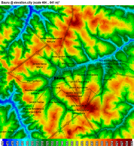
These maps also provides idea of topography and contour of this city, they are displayed at different zoom levels. More info about maps, scale and edge coordinates you can find below images.
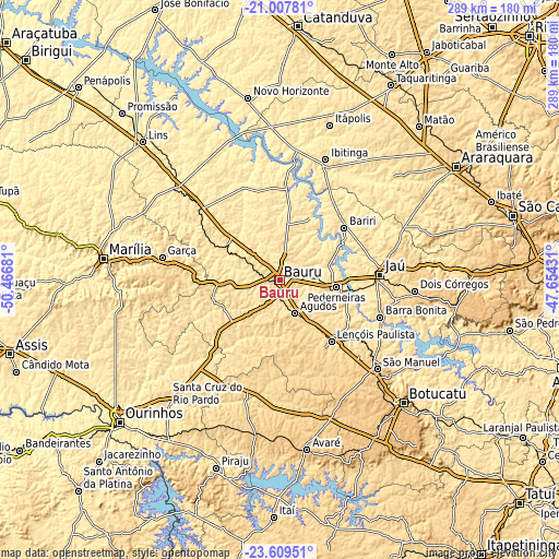
| \ | Map #1 | Map #2 | Topo.Map |
| Scale [m] | 488..632 m | 464..641 m | × |
| Scale [ft] | 1601..2073 ft | 1522..2103 ft | × |
| Average | 558.7 m = 1833 ft | 553 m = 1814 ft | × |
| Width | 9.04 km = 5.6 mi | 18.08 km = 11.2 mi | 289.3 km = 179.8 mi |
| Height | 9.04 km = 5.6 mi | 18.08 km = 11.2 mi | 289.3 km = 179.8 mi |
| ↑Max Latitude | -22.27406° | -22.233388° | -21.00781° |
| Latitude at center | -22.31472° | -22.31472° | -22.31472° |
| ↓Min Latitude | -22.355368° | -22.396005° | -23.60951° |
| ← Min Longitude | -49.104505° | -49.148451° | -50.46681° |
| Longitude center | -49.06056° | -49.06056° | -49.06056° |
| →Max Longitude | -49.016615° | -48.972669° | -47.65431° |
Nearby cities:
Cities around Bauru sort by population:
• Jaú elevation 528 m
51.8 km,  87°
87°
• Lençóis Paulista 562 m
41.4 km,  139°
139°
• Pederneiras 479 m
29.7 km,  97°
97°
• Barra Bonita 467 m
55.4 km,  111°
111°
• Agudos 587 m
18.7 km,  156°
156°
• Bariri 449 m
42.4 km,  50°
50°
• Igaraçu do Tietê 496 m
56 km, 112°
• Pirajuí 499 m
53.9 km,  310°
310°
• Macatuba 532 m
41.5 km,  120°
120°
• Duartina 515 m
37 km,  252°
252°
• Itapuí 462 m
36.3 km,  75°
75°
• Boracéia 485 m
32 km,  64°
64°
Multilingual:
 En español:
Bauru elevación 530 m.
 En France:
Bauru élévation 530 m.


Sources and notes:
- [note 1] Map square and city borders are not equal. Map elevation data is calculated only from area inside that square.
- [src 1] Elevation data from geonames database provided with same terms of usage.
- [src 2] The elevation map of Bauru is generated using elevation data from NASA's 3 arcsec (90m) resolution SRTM data.
- [src 3] Base (background) map © OpenStreetMap contributors tiles are generated by Geofabrik and OpenTopoMap.
Copyright & License:
This Bauru Elevation Map is licensed under CC BY-SA. You may reuse any part from this page, if you give a proper credit by linking to this URL:
 More info on terms of use page.