Macatuba elevation
Macatuba (São Paulo), Brazil elevation is 532 meters and Macatuba elevation in feet is 1745 ft above sea level [src 1]. Macatuba is a populated place (feature code) with elevation that is 150 meters (492 ft) bigger than average city elevation in Brazil.
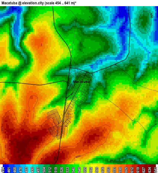
Below is the Elevation map of Macatuba, which displays elevation range with different colors. Scale of the first map is from 454 to 641 m (1490 to 2103 ft) with average elevation of 549.4 meters (=1802 ft) [note 1]
These maps also provides idea of topography and contour of this city, they are displayed at different zoom levels. More info about maps, scale and edge coordinates you can find below images.
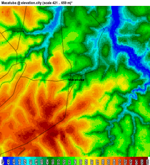
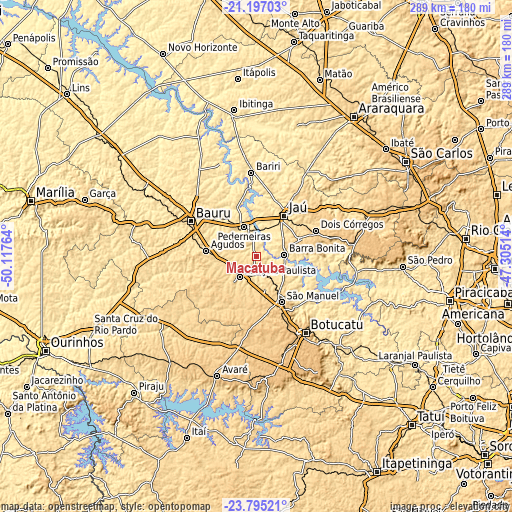
| \ | Map #1 | Map #2 | Topo.Map |
| Scale [m] | 454..641 m | 421..659 m | × |
| Scale [ft] | 1490..2103 ft | 1381..2162 ft | × |
| Average | 549.4 m = 1802 ft | 540.7 m = 1774 ft | × |
| Width | 9.03 km = 5.6 mi | 18.06 km = 11.2 mi | 288.9 km = 179.5 mi |
| Height | 9.03 km = 5.6 mi | 18.06 km = 11.2 mi | 288.9 km = 179.5 mi |
| ↑Max Latitude | -22.461615° | -22.420997° | -21.19703° |
| Latitude at center | -22.50222° | -22.50222° | -22.50222° |
| ↓Min Latitude | -22.542814° | -22.583395° | -23.79521° |
| ← Min Longitude | -48.755335° | -48.799281° | -50.11764° |
| Longitude center | -48.71139° | -48.71139° | -48.71139° |
| →Max Longitude | -48.667445° | -48.623499° | -47.30514° |
Nearby cities:
Cities around Macatuba sort by population:
• Bauru elevation 530 m
41.5 km,  300°
300°
• Jaú 528 m
27.8 km,  34°
34°
• Lençóis Paulista 562 m
14.1 km,  220°
220°
• Pederneiras 479 m
18 km,  338°
338°
• Barra Bonita 467 m
15.8 km,  86°
86°
• São Manuel 704 m
29.3 km,  150°
150°
• Agudos 587 m
28.6 km,  277°
277°
• Bariri 449 m
47.7 km,  356°
356°
• Igaraçu do Tietê 496 m
15.8 km, 92°
• Dois Córregos 673 m
37.2 km,  66°
66°
• Itapuí 462 m
29.9 km, 358°
• Boracéia 485 m
35.1 km,  348°
348°
Multilingual:
 En español:
Macatuba elevación 532 m.
 En France:
Macatuba élévation 532 m.
 Auf Deutsch:
Macatuba höhe über dem Meeresspiegel ist 532 m.

Sources and notes:
- [note 1] Map square and city borders are not equal. Map elevation data is calculated only from area inside that square.
- [src 1] Elevation data from geonames database provided with same terms of usage.
- [src 2] The elevation map of Macatuba is generated using elevation data from NASA's 3 arcsec (90m) resolution SRTM data.
- [src 3] Base (background) map © OpenStreetMap contributors tiles are generated by Geofabrik and OpenTopoMap.
Copyright & License:
This Macatuba Elevation Map is licensed under CC BY-SA. You may reuse any part from this page, if you give a proper credit by linking to this URL:
 More info on terms of use page.