Botucatu elevation
Botucatu (São Paulo), Brazil elevation is 837 meters and Botucatu elevation in feet is 2746 ft above sea level [src 1]. Botucatu is a seat of a second-order administrative division (feature code) with elevation that is 455 meters (1493 ft) bigger than average city elevation in Brazil.
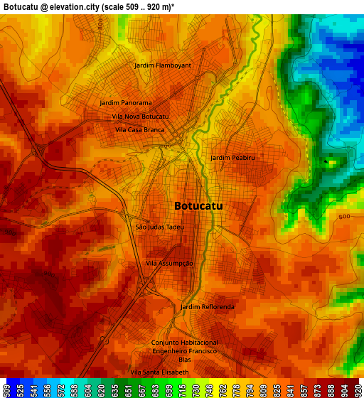
Below is the Elevation map of Botucatu, which displays elevation range with different colors. Scale of the first map is from 509 to 920 m (1670 to 3018 ft) with average elevation of 805.5 meters (=2643 ft) [note 1]
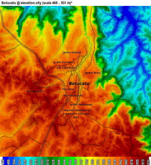
These maps also provides idea of topography and contour of this city, they are displayed at different zoom levels. More info about maps, scale and edge coordinates you can find below images.
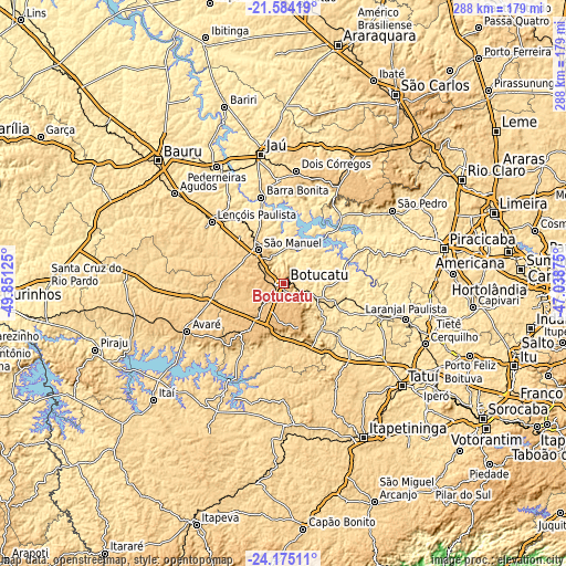
| \ | Map #1 | Map #2 | Topo.Map |
| Scale [m] | 509..920 m | 468..931 m | × |
| Scale [ft] | 1670..3018 ft | 1535..3054 ft | × |
| Average | 805.5 m = 2643 ft | 753.7 m = 2473 ft | × |
| Width | 9 km = 5.6 mi | 18.01 km = 11.2 mi | 288.1 km = 179 mi |
| Height | 9 km = 5.6 mi | 18.01 km = 11.2 mi | 288.1 km = 179 mi |
| ↑Max Latitude | -22.845338° | -22.804834° | -21.58419° |
| Latitude at center | -22.88583° | -22.88583° | -22.88583° |
| ↓Min Latitude | -22.92631° | -22.966778° | -24.17511° |
| ← Min Longitude | -48.488945° | -48.532891° | -49.85125° |
| Longitude center | -48.445° | -48.445° | -48.445° |
| →Max Longitude | -48.401055° | -48.357109° | -47.03875° |
Nearby cities:
Cities around Botucatu sort by population:
• Avaré elevation 768 m
54.6 km,  244°
244°
• Lençóis Paulista 562 m
48.4 km,  311°
311°
• Barra Bonita 467 m
45 km,  345°
345°
• São Manuel 704 m
21.5 km,  323°
323°
• Igaraçu do Tietê 496 m
43.4 km,  344°
344°
• Laranjal Paulista 542 m
64.9 km,  106°
106°
• Dois Córregos 673 m
58.2 km,  6°
6°
• Paranapanema 610 m
62.6 km,  207°
207°
• Macatuba 532 m
50.7 km,  327°
327°
• Itatinga 840 m
29.7 km,  216°
216°
• Conchas 508 m
46.8 km, 107°
• Porangaba 544 m
46 km,  134°
134°
Multilingual:
 En español:
Botucatu elevación 837 m.
 En France:
Botucatu élévation 837 m.
 Auf Deutsch:
Botucatu höhe über dem Meeresspiegel ist 837 m.

Sources and notes:
- [note 1] Map square and city borders are not equal. Map elevation data is calculated only from area inside that square.
- [src 1] Elevation data from geonames database provided with same terms of usage.
- [src 2] The elevation map of Botucatu is generated using elevation data from NASA's 3 arcsec (90m) resolution SRTM data.
- [src 3] Base (background) map © OpenStreetMap contributors tiles are generated by Geofabrik and OpenTopoMap.
Copyright & License:
This Botucatu Elevation Map is licensed under CC BY-SA. You may reuse any part from this page, if you give a proper credit by linking to this URL:
 More info on terms of use page.