Laranjal Paulista elevation
Laranjal Paulista (São Paulo), Brazil elevation is 542 meters and Laranjal Paulista elevation in feet is 1778 ft above sea level [src 1]. Laranjal Paulista is a populated place (feature code) with elevation that is 160 meters (525 ft) bigger than average city elevation in Brazil.
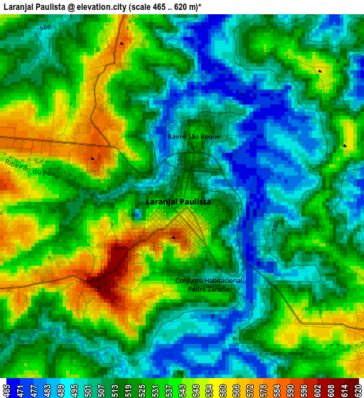
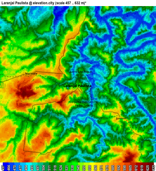
Below is the Elevation map of Laranjal Paulista, which displays elevation range with different colors. Scale of the first map is from 465 to 620 m (1526 to 2034 ft) with average elevation of 522.2 meters (=1713 ft) [note 1]
These maps also provides idea of topography and contour of this city, they are displayed at different zoom levels. More info about maps, scale and edge coordinates you can find below images.
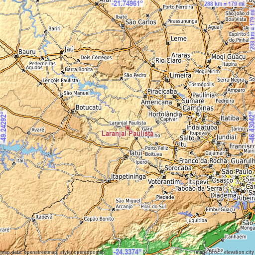
| \ | Map #1 | Map #2 | Topo.Map |
| Scale [m] | 465..620 m | 457..632 m | × |
| Scale [ft] | 1526..2034 ft | 1499..2073 ft | × |
| Average | 522.2 m = 1713 ft | 524.9 m = 1722 ft | × |
| Width | 8.99 km = 5.6 mi | 17.98 km = 11.2 mi | 287.7 km = 178.8 mi |
| Height | 8.99 km = 5.6 mi | 17.98 km = 11.2 mi | 287.8 km = 178.8 mi |
| ↑Max Latitude | -23.009277° | -22.968822° | -21.74961° |
| Latitude at center | -23.04972° | -23.04972° | -23.04972° |
| ↓Min Latitude | -23.090151° | -23.13057° | -24.3374° |
| ← Min Longitude | -47.880615° | -47.924561° | -49.24292° |
| Longitude center | -47.83667° | -47.83667° | -47.83667° |
| →Max Longitude | -47.792725° | -47.748779° | -46.43042° |
Nearby cities:
Cities around Laranjal Paulista sort by population:
• Piracicaba elevation 530 m
40.9 km,  28°
28°
• Tatuí 642 m
34.1 km,  183°
183°
• Boituva 645 m
30.9 km,  147°
147°
• Porto Feliz 541 m
36.9 km,  119°
119°
• Capivari 555 m
34.2 km,  79°
79°
• Cerquilho 587 m
16 km,  143°
143°
• Tietê 513 m
13.8 km,  114°
114°
• Rio das Pedras 625 m
32.9 km,  45°
45°
• Iperó 571 m
36.7 km,  155°
155°
• Conchas 508 m
18.2 km,  282°
282°
• Elias Fausto 579 m
47.4 km,  89°
89°
• Porangaba 544 m
32.7 km,  244°
244°
Multilingual:
 En español:
Laranjal Paulista elevación 542 m.
 En France:
Laranjal Paulista élévation 542 m.
 Auf Deutsch:
Laranjal Paulista höhe über dem Meeresspiegel ist 542 m.

Sources and notes:
- [note 1] Map square and city borders are not equal. Map elevation data is calculated only from area inside that square.
- [src 1] Elevation data from geonames database provided with same terms of usage.
- [src 2] The elevation map of Laranjal Paulista is generated using elevation data from NASA's 3 arcsec (90m) resolution SRTM data.
- [src 3] Base (background) map © OpenStreetMap contributors tiles are generated by Geofabrik and OpenTopoMap.
Copyright & License:
This Laranjal Paulista Elevation Map is licensed under CC BY-SA. You may reuse any part from this page, if you give a proper credit by linking to this URL:
 More info on terms of use page.