Tatuí elevation
Tatuí (São Paulo), Brazil elevation is 642 meters and Tatuí elevation in feet is 2106 ft above sea level [src 1]. Tatuí is a seat of a second-order administrative division (feature code) with elevation that is 260 meters (853 ft) bigger than average city elevation in Brazil.
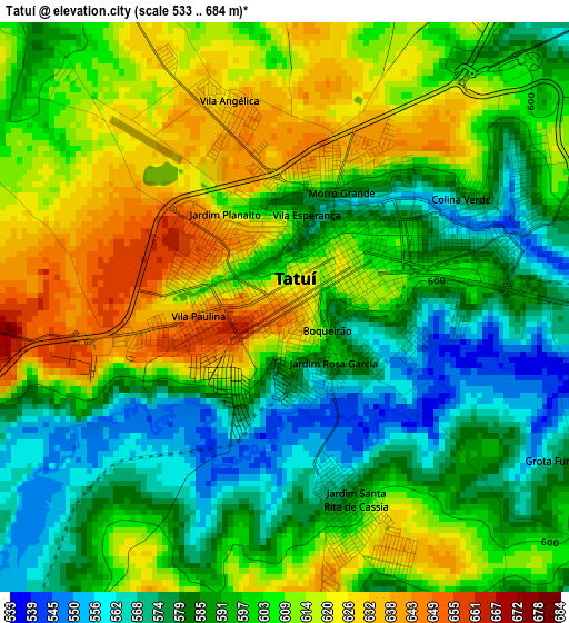
Below is the Elevation map of Tatuí, which displays elevation range with different colors. Scale of the first map is from 533 to 684 m (1749 to 2244 ft) with average elevation of 599.4 meters (=1967 ft) [note 1]
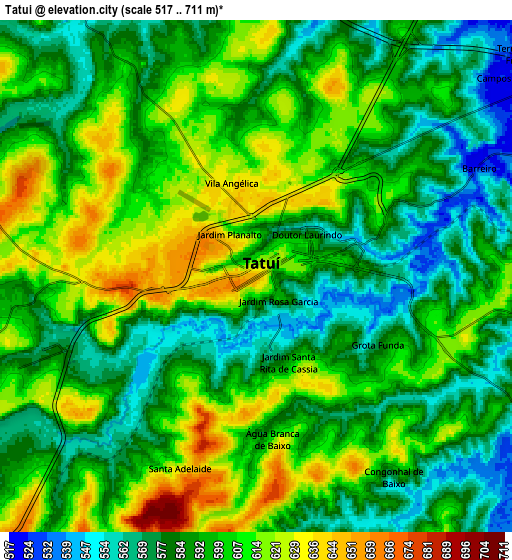
These maps also provides idea of topography and contour of this city, they are displayed at different zoom levels. More info about maps, scale and edge coordinates you can find below images.
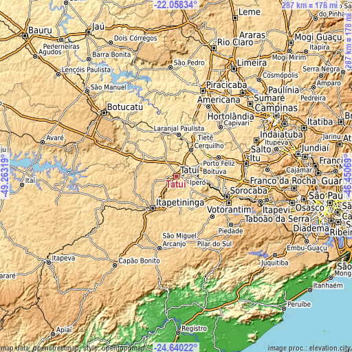
| \ | Map #1 | Map #2 | Topo.Map |
| Scale [m] | 533..684 m | 517..711 m | × |
| Scale [ft] | 1749..2244 ft | 1696..2333 ft | × |
| Average | 599.4 m = 1967 ft | 595.2 m = 1953 ft | × |
| Width | 8.97 km = 5.6 mi | 17.94 km = 11.1 mi | 287.1 km = 178.4 mi |
| Height | 8.97 km = 5.6 mi | 17.94 km = 11.1 mi | 287.1 km = 178.4 mi |
| ↑Max Latitude | -23.315209° | -23.274846° | -22.05834° |
| Latitude at center | -23.35556° | -23.35556° | -23.35556° |
| ↓Min Latitude | -23.395898° | -23.436225° | -24.64022° |
| ← Min Longitude | -47.900885° | -47.944831° | -49.26319° |
| Longitude center | -47.85694° | -47.85694° | -47.85694° |
| →Max Longitude | -47.812995° | -47.769049° | -46.45069° |
Nearby cities:
Cities around Tatuí sort by population:
• Itapetininga elevation 670 m
33 km,  217°
217°
• Boituva 645 m
20.5 km,  66°
66°
• Porto Feliz 541 m
37.4 km, 65°
• Cerquilho 587 m
24.1 km,  28°
28°
• Salto de Pirapora 639 m
43.6 km,  138°
138°
• Tietê 513 m
31.7 km, 27°
• Laranjal Paulista 542 m
34.1 km,  3°
3°
• Iperó 571 m
17.2 km,  88°
88°
• Araçoiaba da Serra 619 m
29.8 km,  123°
123°
• Conchas 508 m
41 km,  337°
337°
• Capela do Alto 621 m
17.9 km, 135°
• Porangaba 544 m
33.9 km,  306°
306°
Multilingual:
 En español:
Tatuí elevación 642 m.
 En France:
Tatuí élévation 642 m.


Sources and notes:
- [note 1] Map square and city borders are not equal. Map elevation data is calculated only from area inside that square.
- [src 1] Elevation data from geonames database provided with same terms of usage.
- [src 2] The elevation map of Tatuí is generated using elevation data from NASA's 3 arcsec (90m) resolution SRTM data.
- [src 3] Base (background) map © OpenStreetMap contributors tiles are generated by Geofabrik and OpenTopoMap.
Copyright & License:
This Tatuí Elevation Map is licensed under CC BY-SA. You may reuse any part from this page, if you give a proper credit by linking to this URL:
 More info on terms of use page.