Capela elevation
Capela (Sergipe), Brazil elevation is 165 meters and Capela elevation in feet is 541 ft above sea level [src 1]. Capela is a populated place (feature code) with elevation that is 217 meters (712 ft) smaller than average city elevation in Brazil.
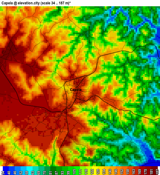
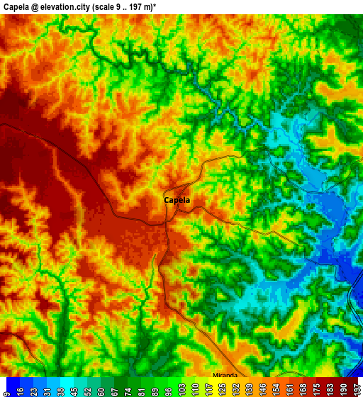
Below is the Elevation map of Capela, which displays elevation range with different colors. Scale of the first map is from 34 to 187 m (112 to 614 ft) with average elevation of 126.2 meters (=414 ft) [note 1]
These maps also provides idea of topography and contour of this city, they are displayed at different zoom levels. More info about maps, scale and edge coordinates you can find below images.
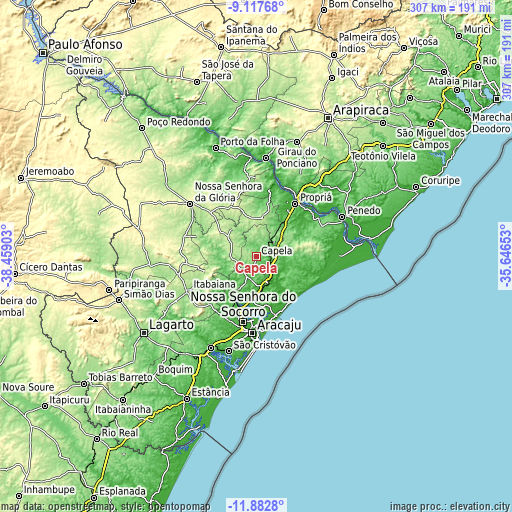
| \ | Map #1 | Map #2 | Topo.Map |
| Scale [m] | 34..187 m | 9..197 m | × |
| Scale [ft] | 112..614 ft | 30..646 ft | × |
| Average | 126.2 m = 414 ft | 114.3 m = 375 ft | × |
| Width | 9.61 km = 6 mi | 19.22 km = 11.9 mi | 307.5 km = 191.1 mi |
| Height | 9.61 km = 6 mi | 19.22 km = 11.9 mi | 307.5 km = 191.1 mi |
| ↑Max Latitude | -10.460118° | -10.4169° | -9.11768° |
| Latitude at center | -10.50333° | -10.50333° | -10.50333° |
| ↓Min Latitude | -10.546536° | -10.589736° | -11.8828° |
| ← Min Longitude | -37.096725° | -37.140671° | -38.45903° |
| Longitude center | -37.05278° | -37.05278° | -37.05278° |
| →Max Longitude | -37.008835° | -36.964889° | -35.64653° |
Nearby cities:
Cities around Capela sort by population:
• Nossa Senhora do Socorro elevation 39 m
39.9 km,  191°
191°
• Propriá 16 m
39.9 km,  35°
35°
• Laranjeiras 49 m
36 km,  200°
200°
• Nossa Senhora das Dores 201 m
15.4 km,  274°
274°
• Maruim 12 m
26.2 km, 186°
• Ribeirópolis 239 m
40 km,  264°
264°
• Aquidabã 219 m
25 km,  8°
8°
• Santo Amaro das Brotas 56 m
31.8 km,  180°
180°
• Japaratuba 89 m
15.9 km,  129°
129°
• Malhador 263 m
32.5 km,  238°
238°
• Japoatã 88 m
32.6 km,  57°
57°
• Moita Bonita 228 m
32.8 km, 255°
Multilingual:
 En español:
Capela elevación 165 m.
 En France:
Capela élévation 165 m.


Sources and notes:
- [note 1] Map square and city borders are not equal. Map elevation data is calculated only from area inside that square.
- [src 1] Elevation data from geonames database provided with same terms of usage.
- [src 2] The elevation map of Capela is generated using elevation data from NASA's 3 arcsec (90m) resolution SRTM data.
- [src 3] Base (background) map © OpenStreetMap contributors tiles are generated by Geofabrik and OpenTopoMap.
Copyright & License:
This Capela Elevation Map is licensed under CC BY-SA. You may reuse any part from this page, if you give a proper credit by linking to this URL:
 More info on terms of use page.