Propriá elevation
Propriá (Sergipe), Brazil elevation is 16 meters and Propriá elevation in feet is 52 ft above sea level [src 1]. Propriá is a populated place (feature code) with elevation that is 366 meters (1201 ft) smaller than average city elevation in Brazil.
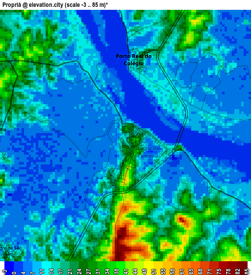
Below is the Elevation map of Propriá, which displays elevation range with different colors. Scale of the first map is from -3 to 85 m (-10 to 279 ft) with average elevation of 14.2 meters (=47 ft) [note 1]
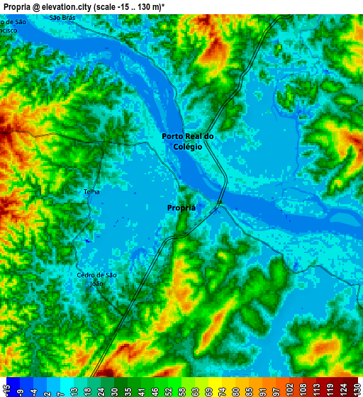
These maps also provides idea of topography and contour of this city, they are displayed at different zoom levels. More info about maps, scale and edge coordinates you can find below images.
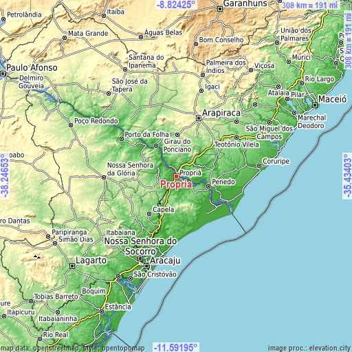
| \ | Map #1 | Map #2 | Topo.Map |
| Scale [m] | -3..85 m | -15..130 m | × |
| Scale [ft] | -10..279 ft | -49..427 ft | × |
| Average | 14.2 m = 47 ft | 29.7 m = 97 ft | × |
| Width | 9.62 km = 6 mi | 19.24 km = 12 mi | 307.7 km = 191.2 mi |
| Height | 9.62 km = 6 mi | 19.24 km = 12 mi | 307.8 km = 191.3 mi |
| ↑Max Latitude | -10.167858° | -10.1246° | -8.82425° |
| Latitude at center | -10.21111° | -10.21111° | -10.21111° |
| ↓Min Latitude | -10.254356° | -10.297597° | -11.59195° |
| ← Min Longitude | -36.884225° | -36.928171° | -38.24653° |
| Longitude center | -36.84028° | -36.84028° | -36.84028° |
| →Max Longitude | -36.796335° | -36.752389° | -35.43403° |
Nearby cities:
Cities around Propriá sort by population:
• Penedo elevation 12 m
29.1 km,  107°
107°
• Capela 165 m
39.9 km,  215°
215°
• Neópolis 49 m
31 km, 112°
• Aquidabã 219 m
21 km,  248°
248°
• Girau do Ponciano 248 m
36.4 km,  1°
1°
• Traipu 30 m
32.2 km,  326°
326°
• Porto Real do Colégio 10 m
2.8 km, 0°
• Igreja Nova 34 m
21.7 km,  63°
63°
• Japoatã 88 m
15.7 km,  164°
164°
• Campo Grande 55 m
37.3 km,  93°
93°
• Gararu 17 m
38 km,  315°
315°
• Pacatuba 64 m
33.9 km,  142°
142°
Multilingual:
 En español:
Propriá elevación 16 m.
 En France:
Propriá élévation 16 m.


Sources and notes:
- [note 1] Map square and city borders are not equal. Map elevation data is calculated only from area inside that square.
- [src 1] Elevation data from geonames database provided with same terms of usage.
- [src 2] The elevation map of Propriá is generated using elevation data from NASA's 3 arcsec (90m) resolution SRTM data.
- [src 3] Base (background) map © OpenStreetMap contributors tiles are generated by Geofabrik and OpenTopoMap.
Copyright & License:
This Propriá Elevation Map is licensed under CC BY-SA. You may reuse any part from this page, if you give a proper credit by linking to this URL:
 More info on terms of use page.