Caarapó elevation
Caarapó (Mato Grosso do Sul), Brazil elevation is 469 meters and Caarapó elevation in feet is 1539 ft above sea level [src 1]. Caarapó is a populated place (feature code) with elevation that is 87 meters (285 ft) bigger than average city elevation in Brazil.
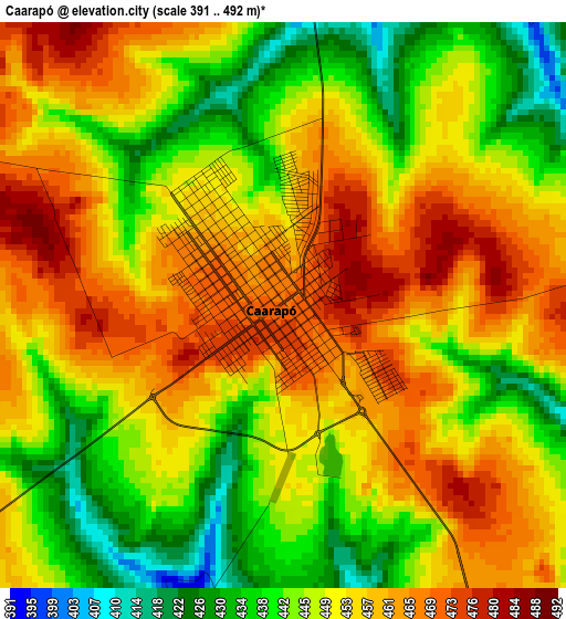
Below is the Elevation map of Caarapó, which displays elevation range with different colors. Scale of the first map is from 391 to 492 m (1283 to 1614 ft) with average elevation of 451.6 meters (=1482 ft) [note 1]
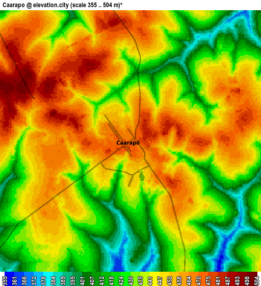
These maps also provides idea of topography and contour of this city, they are displayed at different zoom levels. More info about maps, scale and edge coordinates you can find below images.
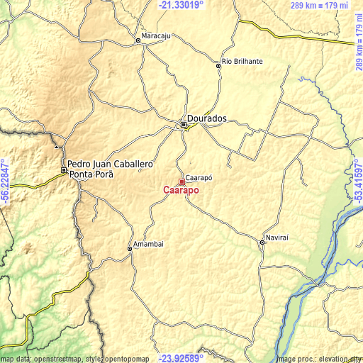
| \ | Map #1 | Map #2 | Topo.Map |
| Scale [m] | 391..492 m | 355..504 m | × |
| Scale [ft] | 1283..1614 ft | 1165..1654 ft | × |
| Average | 451.6 m = 1482 ft | 441.4 m = 1448 ft | × |
| Width | 9.02 km = 5.6 mi | 18.04 km = 11.2 mi | 288.6 km = 179.3 mi |
| Height | 9.02 km = 5.6 mi | 18.04 km = 11.2 mi | 288.6 km = 179.3 mi |
| ↑Max Latitude | -22.593603° | -22.553025° | -21.33019° |
| Latitude at center | -22.63417° | -22.63417° | -22.63417° |
| ↓Min Latitude | -22.674725° | -22.715267° | -23.92589° |
| ← Min Longitude | -54.866165° | -54.910111° | -56.22847° |
| Longitude center | -54.82222° | -54.82222° | -54.82222° |
| →Max Longitude | -54.778275° | -54.734329° | -53.41597° |
Nearby cities:
Cities around Caarapó sort by population:
• Dourados elevation 445 m
46 km,  2°
2°
• Ponta Porã 659 m
93.4 km,  276°
276°
• Naviraí 366 m
80.5 km,  126°
126°
• Maracaju 381 m
118.9 km,  342°
342°
• Rio Brilhante 319 m
96.8 km,  17°
17°
• Pôrto Barra do Ivinheima 234 m
124.1 km,  107°
107°
• Costa Rica 394 m
88.8 km,  168°
168°
• Altãnia 353 m
166.9 km,  145°
145°
• Iguatemi 342 m
119.3 km, 167°
• Eldorado 350 m
139.5 km,  156°
156°
• Bataiporã 326 m
163.8 km,  76°
76°
• Paranhos 417 m
153.1 km,  203°
203°
Multilingual:
 En español:
Caarapó elevación 469 m.
 En France:
Caarapó élévation 469 m.


Sources and notes:
- [note 1] Map square and city borders are not equal. Map elevation data is calculated only from area inside that square.
- [src 1] Elevation data from geonames database provided with same terms of usage.
- [src 2] The elevation map of Caarapó is generated using elevation data from NASA's 3 arcsec (90m) resolution SRTM data.
- [src 3] Base (background) map © OpenStreetMap contributors tiles are generated by Geofabrik and OpenTopoMap.
Copyright & License:
This Caarapó Elevation Map is licensed under CC BY-SA. You may reuse any part from this page, if you give a proper credit by linking to this URL:
 More info on terms of use page.