Bataiporã elevation
Bataiporã (Mato Grosso do Sul, Batayporã), Brazil elevation is 326 meters and Bataiporã elevation in feet is 1070 ft above sea level [src 1]. Bataiporã is a populated place (feature code) with elevation that is 56 meters (184 ft) smaller than average city elevation in Brazil.
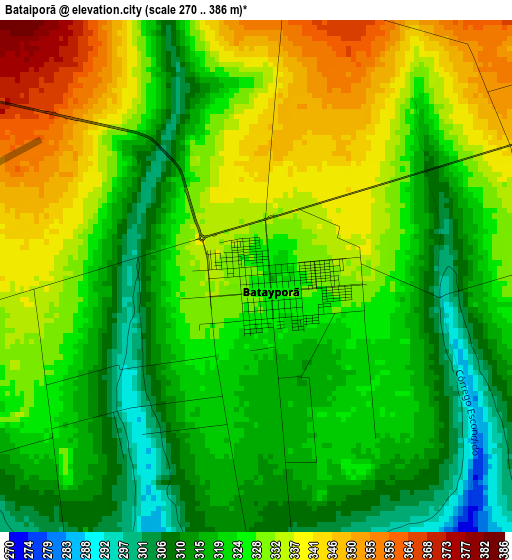
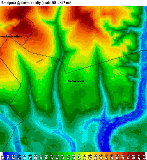
Below is the Elevation map of Bataiporã, which displays elevation range with different colors. Scale of the first map is from 270 to 386 m (886 to 1266 ft) with average elevation of 325.5 meters (=1068 ft) [note 1]
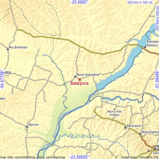
These maps also provides idea of topography and contour of this city, they are displayed at different zoom levels. More info about maps, scale and edge coordinates you can find below images.
| \ | Map #1 | Map #2 | Topo.Map |
| Scale [m] | 270..386 m | 258..417 m | × |
| Scale [ft] | 886..1266 ft | 846..1368 ft | × |
| Average | 325.5 m = 1068 ft | 326 m = 1070 ft | × |
| Width | 9.04 km = 5.6 mi | 18.08 km = 11.2 mi | 289.3 km = 179.8 mi |
| Height | 9.04 km = 5.6 mi | 18.08 km = 11.2 mi | 289.3 km = 179.8 mi |
| ↑Max Latitude | -22.254614° | -22.213936° | -20.9882° |
| Latitude at center | -22.29528° | -22.29528° | -22.29528° |
| ↓Min Latitude | -22.335934° | -22.376576° | -23.59025° |
| ← Min Longitude | -53.315055° | -53.359001° | -54.67736° |
| Longitude center | -53.27111° | -53.27111° | -53.27111° |
| →Max Longitude | -53.227165° | -53.183219° | -51.86486° |
Nearby cities:
Cities around Bataiporã sort by population:
• Paranavaí elevation 456 m
119.6 km,  136°
136°
• Presidente Epitácio 305 m
133 km,  63°
63°
• Naviraí 366 m
127.4 km,  227°
227°
• Rio Brilhante 319 m
142.4 km,  292°
292°
• Loanda 464 m
71.1 km,  168°
168°
• Teodoro Sampaio 342 m
116.5 km,  103°
103°
• Pôrto Barra do Ivinheima 234 m
85 km,  208°
208°
• Nova Londrina 336 m
60 km,  150°
150°
• Alto Paraná 520 m
134.6 km,  133°
133°
• Terra Rica 409 m
81.5 km,  124°
124°
• Mirante do Paranapanema 446 m
140.4 km,  89°
89°
• Nova Aurora 420 m
96.3 km, 131°
Multilingual:
 En español:
Bataiporã elevación 326 m.
 En France:
Bataiporã élévation 326 m.
 Auf Deutsch:
Bataiporã höhe über dem Meeresspiegel ist 326 m.

Sources and notes:
- [note 1] Map square and city borders are not equal. Map elevation data is calculated only from area inside that square.
- [src 1] Elevation data from geonames database provided with same terms of usage.
- [src 2] The elevation map of Bataiporã is generated using elevation data from NASA's 3 arcsec (90m) resolution SRTM data.
- [src 3] Base (background) map © OpenStreetMap contributors tiles are generated by Geofabrik and OpenTopoMap.
Copyright & License:
This Bataiporã Elevation Map is licensed under CC BY-SA. You may reuse any part from this page, if you give a proper credit by linking to this URL:
 More info on terms of use page.