Carinhanha elevation
Carinhanha (Bahia), Brazil elevation is 451 meters and Carinhanha elevation in feet is 1480 ft above sea level [src 1]. Carinhanha is a populated place (feature code) with elevation that is 69 meters (226 ft) bigger than average city elevation in Brazil.
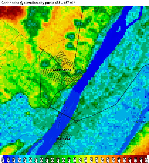
Below is the Elevation map of Carinhanha, which displays elevation range with different colors. Scale of the first map is from 433 to 467 m (1421 to 1532 ft) with average elevation of 443.9 meters (=1456 ft) [note 1]
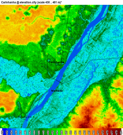
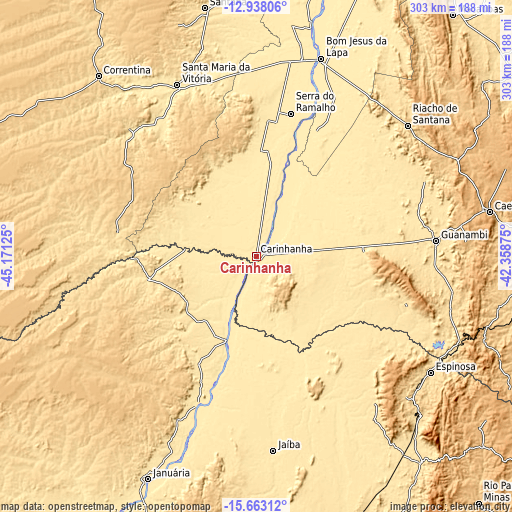
These maps also provides idea of topography and contour of this city, they are displayed at different zoom levels. More info about maps, scale and edge coordinates you can find below images.
| \ | Map #1 | Map #2 | Topo.Map |
| Scale [m] | 433..467 m | 430..481 m | × |
| Scale [ft] | 1421..1532 ft | 1411..1578 ft | × |
| Average | 443.9 m = 1456 ft | 449 m = 1473 ft | × |
| Width | 9.47 km = 5.9 mi | 18.94 km = 11.8 mi | 303 km = 188.3 mi |
| Height | 9.47 km = 5.9 mi | 18.94 km = 11.8 mi | 303 km = 188.3 mi |
| ↑Max Latitude | -14.262133° | -14.219538° | -12.93806° |
| Latitude at center | -14.30472° | -14.30472° | -14.30472° |
| ↓Min Latitude | -14.347299° | -14.389869° | -15.66312° |
| ← Min Longitude | -43.808945° | -43.852891° | -45.17125° |
| Longitude center | -43.765° | -43.765° | -43.765° |
| →Max Longitude | -43.721055° | -43.677109° | -42.35875° |
Nearby cities:
Cities around Carinhanha sort by population:
• Guanambi elevation 531 m
106.4 km,  85°
85°
• Bom Jesus da Lapa 439 m
122.6 km,  17°
17°
• Januária 459 m
146.3 km,  205°
205°
• Caetité 818 m
141.5 km,  79°
79°
• Santa Maria da Vitória 464 m
112.2 km,  335°
335°
• Espinosa 567 m
123 km,  124°
124°
• Correntina 584 m
142.4 km,  318°
318°
• Itacarambi 442 m
95.4 km,  201°
201°
• Riacho de Santana 626 m
118 km,  49°
49°
• Manga 454 m
53.3 km, 199°
• Monte Azul 584 m
134.5 km,  134°
134°
• Palmas de Monte Alto 565 m
65.1 km, 86°
Multilingual:
 En español:
Carinhanha elevación 451 m.
 En France:
Carinhanha élévation 451 m.
 Auf Deutsch:
Carinhanha höhe über dem Meeresspiegel ist 451 m.

Sources and notes:
- [note 1] Map square and city borders are not equal. Map elevation data is calculated only from area inside that square.
- [src 1] Elevation data from geonames database provided with same terms of usage.
- [src 2] The elevation map of Carinhanha is generated using elevation data from NASA's 3 arcsec (90m) resolution SRTM data.
- [src 3] Base (background) map © OpenStreetMap contributors tiles are generated by Geofabrik and OpenTopoMap.
Copyright & License:
This Carinhanha Elevation Map is licensed under CC BY-SA. You may reuse any part from this page, if you give a proper credit by linking to this URL:
 More info on terms of use page.