Monte Azul elevation
Monte Azul (Minas Gerais), Brazil elevation is 584 meters and Monte Azul elevation in feet is 1916 ft above sea level [src 1]. Monte Azul is a populated place (feature code) with elevation that is 202 meters (663 ft) bigger than average city elevation in Brazil.
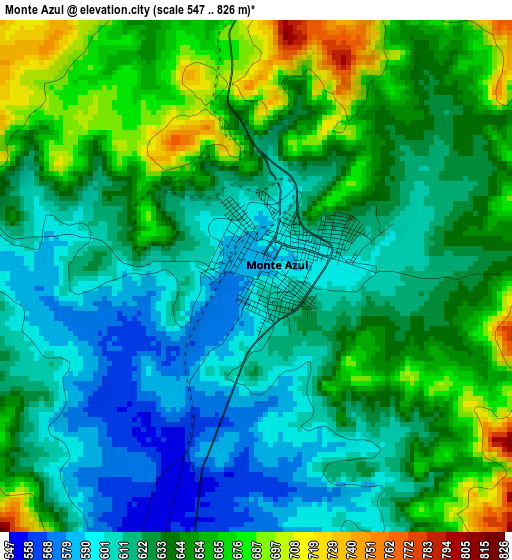
Below is the Elevation map of Monte Azul, which displays elevation range with different colors. Scale of the first map is from 547 to 826 m (1795 to 2710 ft) with average elevation of 633.6 meters (=2079 ft) [note 1]
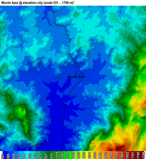
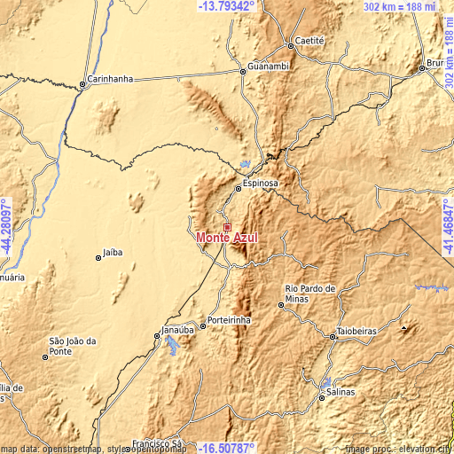
These maps also provides idea of topography and contour of this city, they are displayed at different zoom levels. More info about maps, scale and edge coordinates you can find below images.
| \ | Map #1 | Map #2 | Topo.Map |
| Scale [m] | 547..826 m | 531..1798 m | × |
| Scale [ft] | 1795..2710 ft | 1742..5899 ft | × |
| Average | 633.6 m = 2079 ft | 765.3 m = 2511 ft | × |
| Width | 9.43 km = 5.9 mi | 18.87 km = 11.7 mi | 301.8 km = 187.5 mi |
| Height | 9.43 km = 5.9 mi | 18.87 km = 11.7 mi | 301.8 km = 187.5 mi |
| ↑Max Latitude | -15.112579° | -15.070149° | -13.79342° |
| Latitude at center | -15.155° | -15.155° | -15.155° |
| ↓Min Latitude | -15.197413° | -15.239817° | -16.50787° |
| ← Min Longitude | -42.918665° | -42.962611° | -44.28097° |
| Longitude center | -42.87472° | -42.87472° | -42.87472° |
| →Max Longitude | -42.830775° | -42.786829° | -41.46847° |
Nearby cities:
Cities around Monte Azul sort by population:
• Guanambi elevation 531 m
104.1 km,  5°
5°
• Janaúba 539 m
85.7 km,  212°
212°
• Taiobeiras 832 m
100 km,  136°
136°
• Barreiro do Jaíba 584 m
92.4 km,  236°
236°
• Espinosa 567 m
26.1 km, 13°
• Porteirinha 570 m
67.5 km,  194°
194°
• Caculé 584 m
100.8 km,  44°
44°
• Manga 454 m
122 km,  291°
291°
• Rio Pardo de Minas 771 m
62 km, 144°
• São João do Paraíso 789 m
94 km,  100°
100°
• Mato Verde 543 m
26.9 km,  178°
178°
• Palmas de Monte Alto 565 m
103.4 km,  342°
342°
Multilingual:
 En español:
Monte Azul elevación 584 m.
 En France:
Monte Azul élévation 584 m.
 Auf Deutsch:
Monte Azul höhe über dem Meeresspiegel ist 584 m.

Sources and notes:
- [note 1] Map square and city borders are not equal. Map elevation data is calculated only from area inside that square.
- [src 1] Elevation data from geonames database provided with same terms of usage.
- [src 2] The elevation map of Monte Azul is generated using elevation data from NASA's 3 arcsec (90m) resolution SRTM data.
- [src 3] Base (background) map © OpenStreetMap contributors tiles are generated by Geofabrik and OpenTopoMap.
Copyright & License:
This Monte Azul Elevation Map is licensed under CC BY-SA. You may reuse any part from this page, if you give a proper credit by linking to this URL:
 More info on terms of use page.