Manga elevation
Manga (Minas Gerais), Brazil elevation is 454 meters and Manga elevation in feet is 1490 ft above sea level [src 1]. Manga is a populated place (feature code) with elevation that is 72 meters (236 ft) bigger than average city elevation in Brazil.
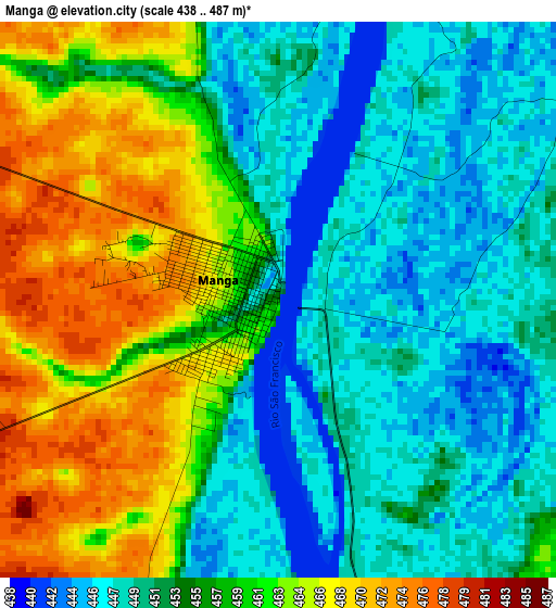
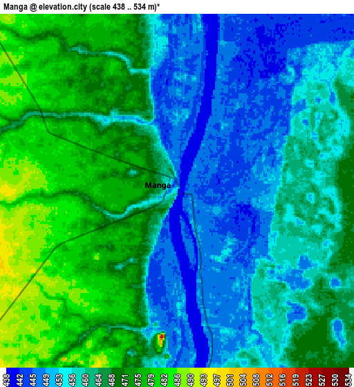
Below is the Elevation map of Manga, which displays elevation range with different colors. Scale of the first map is from 438 to 487 m (1437 to 1598 ft) with average elevation of 455.7 meters (=1495 ft) [note 1]
These maps also provides idea of topography and contour of this city, they are displayed at different zoom levels. More info about maps, scale and edge coordinates you can find below images.
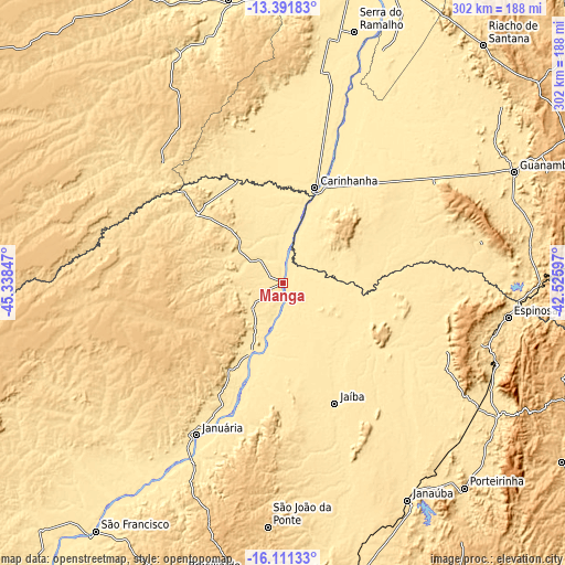
| \ | Map #1 | Map #2 | Topo.Map |
| Scale [m] | 438..487 m | 438..534 m | × |
| Scale [ft] | 1437..1598 ft | 1437..1752 ft | × |
| Average | 455.7 m = 1495 ft | 462.8 m = 1518 ft | × |
| Width | 9.45 km = 5.9 mi | 18.9 km = 11.7 mi | 302.4 km = 187.9 mi |
| Height | 9.45 km = 5.9 mi | 18.9 km = 11.7 mi | 302.4 km = 187.9 mi |
| ↑Max Latitude | -14.71333° | -14.670821° | -13.39183° |
| Latitude at center | -14.75583° | -14.75583° | -14.75583° |
| ↓Min Latitude | -14.798322° | -14.840805° | -16.11133° |
| ← Min Longitude | -43.976165° | -44.020111° | -45.33847° |
| Longitude center | -43.93222° | -43.93222° | -43.93222° |
| →Max Longitude | -43.888275° | -43.844329° | -42.52597° |
Nearby cities:
Cities around Manga sort by population:
• Guanambi elevation 531 m
137.3 km,  64°
64°
• Janaúba 539 m
134.2 km,  150°
150°
• Januária 459 m
93.5 km,  209°
209°
• Barreiro do Jaíba 584 m
102.3 km,  159°
159°
• Espinosa 567 m
121.1 km,  98°
98°
• Itacarambi 442 m
42.2 km,  204°
204°
• Carinhanha 451 m
53.3 km,  19°
19°
• Monte Azul 584 m
122 km,  111°
111°
• São João da Ponte 717 m
130.7 km,  183°
183°
• Mato Verde 543 m
134.8 km,  121°
121°
• Palmas de Monte Alto 565 m
99.1 km, 56°
• Varzelândia 745 m
105.6 km,  185°
185°
Multilingual:
 En español:
Manga elevación 454 m.
 En France:
Manga élévation 454 m.


Sources and notes:
- [note 1] Map square and city borders are not equal. Map elevation data is calculated only from area inside that square.
- [src 1] Elevation data from geonames database provided with same terms of usage.
- [src 2] The elevation map of Manga is generated using elevation data from NASA's 3 arcsec (90m) resolution SRTM data.
- [src 3] Base (background) map © OpenStreetMap contributors tiles are generated by Geofabrik and OpenTopoMap.
Copyright & License:
This Manga Elevation Map is licensed under CC BY-SA. You may reuse any part from this page, if you give a proper credit by linking to this URL:
 More info on terms of use page.