Carmo elevation
Carmo (Rio de Janeiro), Brazil elevation is 354 meters and Carmo elevation in feet is 1161 ft above sea level [src 1]. Carmo is a populated place (feature code) with elevation that is 28 meters (92 ft) smaller than average city elevation in Brazil.
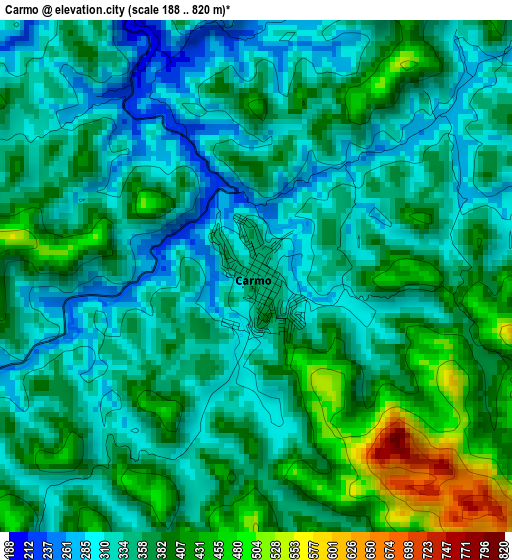
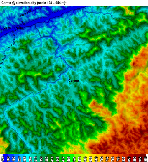
Below is the Elevation map of Carmo, which displays elevation range with different colors. Scale of the first map is from 188 to 820 m (617 to 2690 ft) with average elevation of 360.4 meters (=1182 ft) [note 1]
These maps also provides idea of topography and contour of this city, they are displayed at different zoom levels. More info about maps, scale and edge coordinates you can find below images.
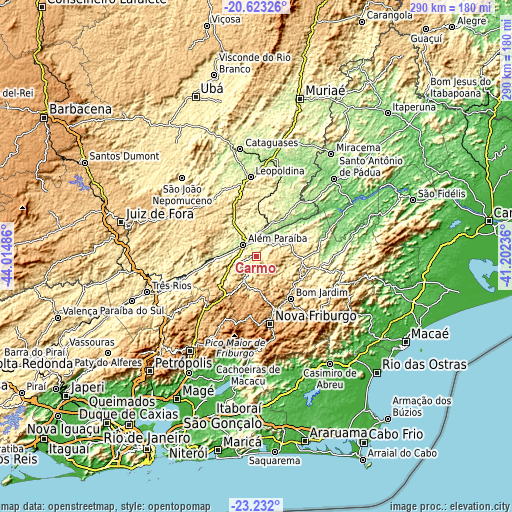
| \ | Map #1 | Map #2 | Topo.Map |
| Scale [m] | 188..820 m | 128..954 m | × |
| Scale [ft] | 617..2690 ft | 420..3130 ft | × |
| Average | 360.4 m = 1182 ft | 416.8 m = 1367 ft | × |
| Width | 9.07 km = 5.6 mi | 18.13 km = 11.3 mi | 290.1 km = 180.3 mi |
| Height | 9.07 km = 5.6 mi | 18.13 km = 11.3 mi | 290.1 km = 180.3 mi |
| ↑Max Latitude | -21.89284° | -21.852058° | -20.62326° |
| Latitude at center | -21.93361° | -21.93361° | -21.93361° |
| ↓Min Latitude | -21.974369° | -22.015115° | -23.232° |
| ← Min Longitude | -42.652555° | -42.696501° | -44.01486° |
| Longitude center | -42.60861° | -42.60861° | -42.60861° |
| →Max Longitude | -42.564665° | -42.520719° | -41.20236° |
Nearby cities:
Cities around Carmo sort by population:
• Nova Friburgo elevation 858 m
39.5 km,  168°
168°
• Leopoldina 250 m
44.8 km,  355°
355°
• Cachoeiras de Macacu 63 m
59 km,  184°
184°
• Além Paraíba 148 m
11.1 km,  297°
297°
• São João Nepomuceno 378 m
60.3 km,  316°
316°
• Cordeiro 491 m
27.6 km,  112°
112°
• Cantagalo 431 m
25.4 km,  102°
102°
• Bicas 638 m
52 km, 296°
• Sapucaia 224 m
32.3 km,  257°
257°
• Areal 496 m
60.9 km,  237°
237°
• Mar de Espanha 484 m
42 km,  280°
280°
• Recreio 180 m
47.7 km,  17°
17°
Multilingual:
 En español:
Carmo elevación 354 m.
 En France:
Carmo élévation 354 m.


Sources and notes:
- [note 1] Map square and city borders are not equal. Map elevation data is calculated only from area inside that square.
- [src 1] Elevation data from geonames database provided with same terms of usage.
- [src 2] The elevation map of Carmo is generated using elevation data from NASA's 3 arcsec (90m) resolution SRTM data.
- [src 3] Base (background) map © OpenStreetMap contributors tiles are generated by Geofabrik and OpenTopoMap.
Copyright & License:
This Carmo Elevation Map is licensed under CC BY-SA. You may reuse any part from this page, if you give a proper credit by linking to this URL:
 More info on terms of use page.