São João Nepomuceno elevation
São João Nepomuceno (Minas Gerais), Brazil elevation is 378 meters and São João Nepomuceno elevation in feet is 1240 ft above sea level [src 1]. São João Nepomuceno is a populated place (feature code) with elevation that is 4 meters (13 ft) smaller than average city elevation in Brazil.
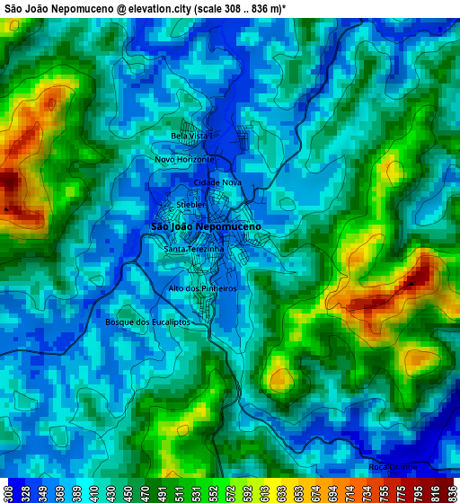
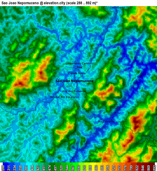
Below is the Elevation map of São João Nepomuceno, which displays elevation range with different colors. Scale of the first map is from 308 to 836 m (1010 to 2743 ft) with average elevation of 443.2 meters (=1454 ft) [note 1]
These maps also provides idea of topography and contour of this city, they are displayed at different zoom levels. More info about maps, scale and edge coordinates you can find below images.
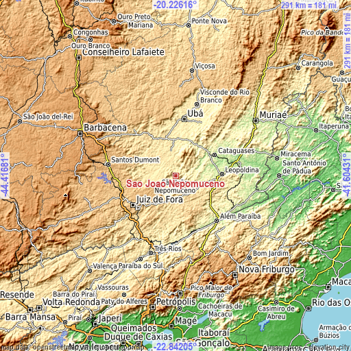
| \ | Map #1 | Map #2 | Topo.Map |
| Scale [m] | 308..836 m | 288..892 m | × |
| Scale [ft] | 1010..2743 ft | 945..2927 ft | × |
| Average | 443.2 m = 1454 ft | 460.4 m = 1510 ft | × |
| Width | 9.09 km = 5.6 mi | 18.18 km = 11.3 mi | 290.9 km = 180.8 mi |
| Height | 9.09 km = 5.6 mi | 18.18 km = 11.3 mi | 290.9 km = 180.8 mi |
| ↑Max Latitude | -21.499118° | -21.458225° | -20.22616° |
| Latitude at center | -21.54° | -21.54° | -21.54° |
| ↓Min Latitude | -21.58087° | -21.621729° | -22.84205° |
| ← Min Longitude | -43.054505° | -43.098451° | -44.41681° |
| Longitude center | -43.01056° | -43.01056° | -43.01056° |
| →Max Longitude | -42.966615° | -42.922669° | -41.60431° |
Nearby cities:
Cities around São João Nepomuceno sort by population:
• Juiz de Fora elevation 707 m
43.1 km,  234°
234°
• Ubá 343 m
47.2 km,  8°
8°
• Cataguases 180 m
36.6 km,  62°
62°
• Leopoldina 250 m
38 km,  88°
88°
• Além Paraíba 148 m
50 km,  140°
140°
• Rio Pomba 448 m
34.3 km,  329°
329°
• Tocantins 356 m
40.6 km,  358°
358°
• Bicas 638 m
21.2 km,  193°
193°
• Matias Barbosa 481 m
48.6 km,  221°
221°
• Astolfo Dutra 256 m
29.3 km,  31°
31°
• Mar de Espanha 484 m
36.4 km,  179°
179°
• Rio Novo 412 m
13.8 km,  300°
300°
Multilingual:
 En español:
São João Nepomuceno elevación 378 m.
 En France:
São João Nepomuceno élévation 378 m.
 Auf Deutsch:
São João Nepomuceno höhe über dem Meeresspiegel ist 378 m.
 На русском:
Сан-Жуан-Непомусено высота над уровнем моря 378 м
Sources and notes:
- [note 1] Map square and city borders are not equal. Map elevation data is calculated only from area inside that square.
- [src 1] Elevation data from geonames database provided with same terms of usage.
- [src 2] The elevation map of São João Nepomuceno is generated using elevation data from NASA's 3 arcsec (90m) resolution SRTM data.
- [src 3] Base (background) map © OpenStreetMap contributors tiles are generated by Geofabrik and OpenTopoMap.
Copyright & License:
This São João Nepomuceno Elevation Map is licensed under CC BY-SA. You may reuse any part from this page, if you give a proper credit by linking to this URL:
 More info on terms of use page.