Ubá elevation
Ubá (Minas Gerais), Brazil elevation is 343 meters and Ubá elevation in feet is 1125 ft above sea level [src 1]. Ubá is a populated place (feature code) with elevation that is 39 meters (128 ft) smaller than average city elevation in Brazil.
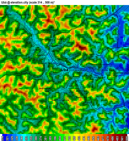
Below is the Elevation map of Ubá, which displays elevation range with different colors. Scale of the first map is from 314 to 508 m (1030 to 1667 ft) with average elevation of 388.8 meters (=1276 ft) [note 1]
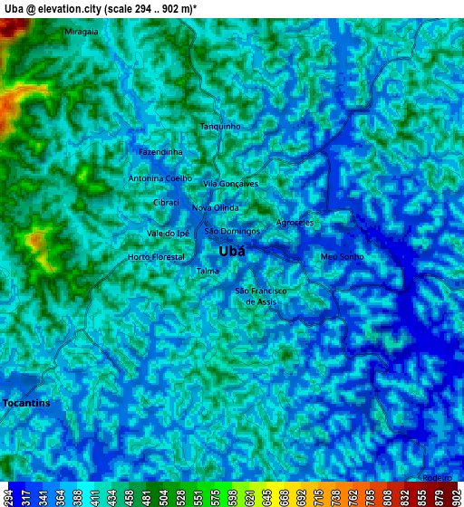
These maps also provides idea of topography and contour of this city, they are displayed at different zoom levels. More info about maps, scale and edge coordinates you can find below images.
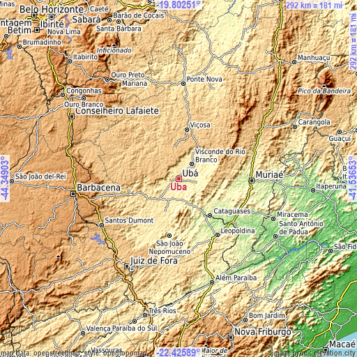
| \ | Map #1 | Map #2 | Topo.Map |
| Scale [m] | 314..508 m | 294..902 m | × |
| Scale [ft] | 1030..1667 ft | 965..2959 ft | × |
| Average | 388.8 m = 1276 ft | 401.1 m = 1316 ft | × |
| Width | 9.12 km = 5.7 mi | 18.23 km = 11.3 mi | 291.7 km = 181.3 mi |
| Height | 9.12 km = 5.7 mi | 18.23 km = 11.3 mi | 291.7 km = 181.3 mi |
| ↑Max Latitude | -21.079001° | -21.037991° | -19.80251° |
| Latitude at center | -21.12° | -21.12° | -21.12° |
| ↓Min Latitude | -21.160988° | -21.201964° | -22.42589° |
| ← Min Longitude | -42.986725° | -43.030671° | -44.34903° |
| Longitude center | -42.94278° | -42.94278° | -42.94278° |
| →Max Longitude | -42.898835° | -42.854889° | -41.53653° |
Nearby cities:
Cities around Ubá sort by population:
• Muriaé elevation 212 m
59.8 km,  91°
91°
• Viçosa 656 m
41.2 km,  8°
8°
• Cataguases 180 m
39.3 km,  139°
139°
• Leopoldina 250 m
55.3 km,  145°
145°
• Visconde do Rio Branco 343 m
16.2 km,  41°
41°
• São João Nepomuceno 378 m
47.2 km,  188°
188°
• Rio Pomba 448 m
29.9 km,  234°
234°
• Tocantins 356 m
9.9 km, 231°
• Astolfo Dutra 256 m
23.3 km,  158°
158°
• Recreio 180 m
66.6 km,  132°
132°
• Miraí 343 m
35.1 km,  103°
103°
• Rio Novo 412 m
44 km,  205°
205°
Multilingual:
 En español:
Ubá elevación 343 m.
 En France:
Ubá élévation 343 m.


Sources and notes:
- [note 1] Map square and city borders are not equal. Map elevation data is calculated only from area inside that square.
- [src 1] Elevation data from geonames database provided with same terms of usage.
- [src 2] The elevation map of Ubá is generated using elevation data from NASA's 3 arcsec (90m) resolution SRTM data.
- [src 3] Base (background) map © OpenStreetMap contributors tiles are generated by Geofabrik and OpenTopoMap.
Copyright & License:
This Ubá Elevation Map is licensed under CC BY-SA. You may reuse any part from this page, if you give a proper credit by linking to this URL:
 More info on terms of use page.