Corumbá elevation
Corumbá (Mato Grosso do Sul), Brazil elevation is 152 meters and Corumbá elevation in feet is 499 ft above sea level [src 1]. Corumbá is a populated place (feature code) with elevation that is 230 meters (755 ft) smaller than average city elevation in Brazil.
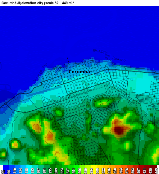
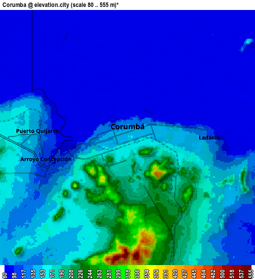
Below is the Elevation map of Corumbá, which displays elevation range with different colors. Scale of the first map is from 82 to 449 m (269 to 1473 ft) with average elevation of 145.6 meters (=478 ft) [note 1]
These maps also provides idea of topography and contour of this city, they are displayed at different zoom levels. More info about maps, scale and edge coordinates you can find below images.
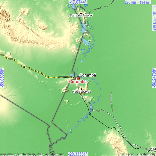
| \ | Map #1 | Map #2 | Topo.Map |
| Scale [m] | 82..449 m | 80..555 m | × |
| Scale [ft] | 269..1473 ft | 262..1821 ft | × |
| Average | 145.6 m = 478 ft | 136.4 m = 448 ft | × |
| Width | 9.24 km = 5.7 mi | 18.48 km = 11.5 mi | 295.6 km = 183.7 mi |
| Height | 9.24 km = 5.7 mi | 18.48 km = 11.5 mi | 295.7 km = 183.7 mi |
| ↑Max Latitude | -18.967616° | -18.926052° | -17.6744° |
| Latitude at center | -19.00917° | -19.00917° | -19.00917° |
| ↓Min Latitude | -19.050714° | -19.092247° | -20.33331° |
| ← Min Longitude | -57.697275° | -57.741221° | -59.05958° |
| Longitude center | -57.65333° | -57.65333° | -57.65333° |
| →Max Longitude | -57.609385° | -57.565439° | -56.24708° |
Nearby cities:
Cities around Corumbá sort by population:
• Aquidauana elevation 157 m
254.1 km,  129°
129°
• Coxim 205 m
309.7 km,  79°
79°
• Jardim 256 m
317 km,  150°
150°
• Poconé 150 m
324.9 km,  19°
19°
• Anastácio 170 m
253.4 km, 130°
• Rio Verde de Mato Grosso 335 m
295.6 km,  88°
88°
• Ladário 126 m
5.5 km, 84°
• Bonito 306 m
264.8 km, 152°
• Miranda 131 m
191.2 km,  135°
135°
• Porto Murtinho 79 m
300 km,  184°
184°
• Guia Lopes da Laguna 246 m
316.1 km, 149°
• Terenos 429 m
332.9 km,  118°
118°
Multilingual:
 En español:
Corumbá elevación 152 m.
 En France:
Corumbá élévation 152 m.


Sources and notes:
- [note 1] Map square and city borders are not equal. Map elevation data is calculated only from area inside that square.
- [src 1] Elevation data from geonames database provided with same terms of usage.
- [src 2] The elevation map of Corumbá is generated using elevation data from NASA's 3 arcsec (90m) resolution SRTM data.
- [src 3] Base (background) map © OpenStreetMap contributors tiles are generated by Geofabrik and OpenTopoMap.
Copyright & License:
This Corumbá Elevation Map is licensed under CC BY-SA. You may reuse any part from this page, if you give a proper credit by linking to this URL:
 More info on terms of use page.