Miranda elevation
Miranda (Mato Grosso do Sul), Brazil elevation is 131 meters and Miranda elevation in feet is 430 ft above sea level [src 1]. Miranda is a populated place (feature code) with elevation that is 251 meters (823 ft) smaller than average city elevation in Brazil.
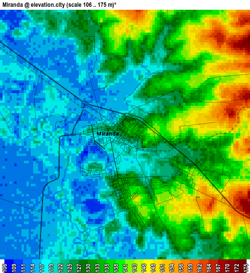
Below is the Elevation map of Miranda, which displays elevation range with different colors. Scale of the first map is from 106 to 175 m (348 to 574 ft) with average elevation of 127.7 meters (=419 ft) [note 1]
These maps also provides idea of topography and contour of this city, they are displayed at different zoom levels. More info about maps, scale and edge coordinates you can find below images.
| \ | Map #1 | Map #2 | Topo.Map |
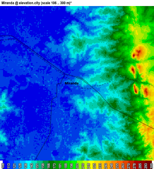
| Scale [m] | 106..175 m | 106..300 m | × |
| Scale [ft] | 348..574 ft | 348..984 ft | × |
| Average | 127.7 m = 419 ft | 139.9 m = 459 ft | × |
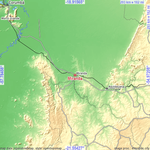
| Width | 9.17 km = 5.7 mi | 18.34 km = 11.4 mi | 293.4 km = 182.3 mi |
| Height | 9.17 km = 5.7 mi | 18.34 km = 11.4 mi | 293.4 km = 182.3 mi |
| ↑Max Latitude | -20.199323° | -20.158075° | -18.91565° |
| Latitude at center | -20.24056° | -20.24056° | -20.24056° |
| ↓Min Latitude | -20.281786° | -20.323001° | -21.55427° |
| ← Min Longitude | -56.422275° | -56.466221° | -57.78458° |
| Longitude center | -56.37833° | -56.37833° | -56.37833° |
| →Max Longitude | -56.334385° | -56.290439° | -54.97208° |
Nearby cities:
Cities around Miranda sort by population:
• Campo Grande elevation 592 m
182 km,  97°
97°
• Corumbá 152 m
191.2 km,  315°
315°
• Aquidauana 157 m
66.7 km,  112°
112°
• Jardim 256 m
140.1 km,  169°
169°
• Maracaju 381 m
197.8 km,  140°
140°
• Anastácio 170 m
65.4 km, 114°
• Bela Vista 190 m
208.3 km,  184°
184°
• Sidrolândia 491 m
166.3 km,  117°
117°
• Ladário 126 m
187.9 km, 317°
• Bonito 306 m
98.5 km,  186°
186°
• Guia Lopes da Laguna 246 m
138.1 km, 168°
• Terenos 429 m
159.8 km, 98°
Multilingual:
 En español:
Miranda elevación 131 m.
 En France:
Miranda élévation 131 m.


Sources and notes:
- [note 1] Map square and city borders are not equal. Map elevation data is calculated only from area inside that square.
- [src 1] Elevation data from geonames database provided with same terms of usage.
- [src 2] The elevation map of Miranda is generated using elevation data from NASA's 3 arcsec (90m) resolution SRTM data.
- [src 3] Base (background) map © OpenStreetMap contributors tiles are generated by Geofabrik and OpenTopoMap.
Copyright & License:
This Miranda Elevation Map is licensed under CC BY-SA. You may reuse any part from this page, if you give a proper credit by linking to this URL:
 More info on terms of use page.