Sidrolândia elevation
Sidrolândia (Mato Grosso do Sul), Brazil elevation is 491 meters and Sidrolândia elevation in feet is 1611 ft above sea level [src 1]. Sidrolândia is a populated place (feature code) with elevation that is 109 meters (358 ft) bigger than average city elevation in Brazil.
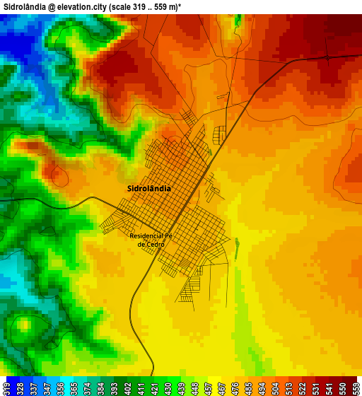
Below is the Elevation map of Sidrolândia, which displays elevation range with different colors. Scale of the first map is from 319 to 559 m (1047 to 1834 ft) with average elevation of 466.6 meters (=1531 ft) [note 1]
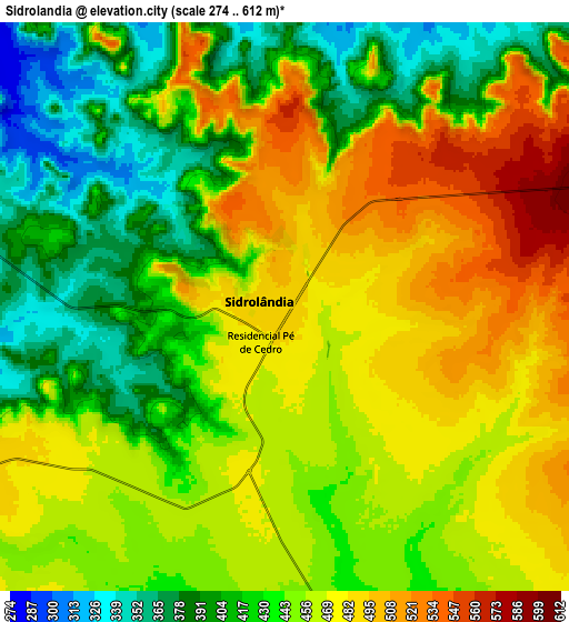
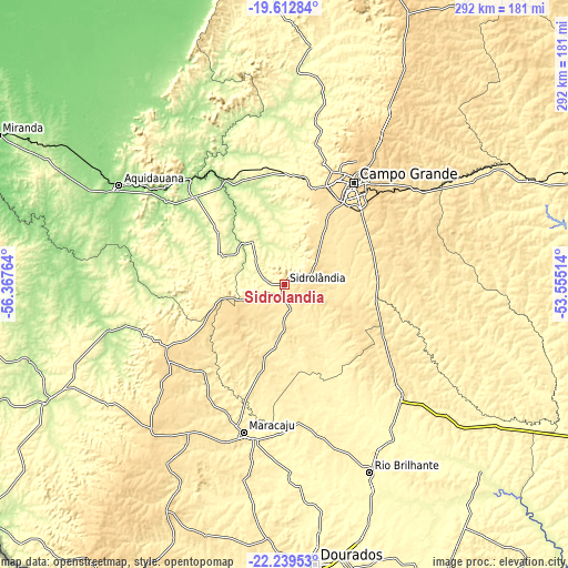
These maps also provides idea of topography and contour of this city, they are displayed at different zoom levels. More info about maps, scale and edge coordinates you can find below images.
| \ | Map #1 | Map #2 | Topo.Map |
| Scale [m] | 319..559 m | 274..612 m | × |
| Scale [ft] | 1047..1834 ft | 899..2008 ft | × |
| Average | 466.6 m = 1531 ft | 447.3 m = 1468 ft | × |
| Width | 9.13 km = 5.7 mi | 18.26 km = 11.3 mi | 292.1 km = 181.5 mi |
| Height | 9.13 km = 5.7 mi | 18.26 km = 11.3 mi | 292.1 km = 181.5 mi |
| ↑Max Latitude | -20.890889° | -20.849827° | -19.61284° |
| Latitude at center | -20.93194° | -20.93194° | -20.93194° |
| ↓Min Latitude | -20.97298° | -21.014008° | -22.23953° |
| ← Min Longitude | -55.005335° | -55.049281° | -56.36764° |
| Longitude center | -54.96139° | -54.96139° | -54.96139° |
| →Max Longitude | -54.917445° | -54.873499° | -53.55514° |
Nearby cities:
Cities around Sidrolândia sort by population:
• Campo Grande elevation 592 m
63.5 km,  31°
31°
• Dourados 445 m
144.2 km,  173°
173°
• Aquidauana 157 m
100 km,  300°
300°
• Jardim 256 m
136.4 km,  243°
243°
• Campo Verde 471 m
109.3 km,  58°
58°
• Maracaju 381 m
78.9 km,  195°
195°
• Rio Brilhante 319 m
105.8 km,  156°
156°
• Anastácio 170 m
101.1 km, 299°
• Bonito 306 m
159.2 km,  262°
262°
• Ribas do Rio Pardo 382 m
136.4 km,  66°
66°
• Guia Lopes da Laguna 246 m
133 km, 243°
• Terenos 429 m
55.5 km,  10°
10°
Multilingual:
 En español:
Sidrolândia elevación 491 m.
 En France:
Sidrolândia élévation 491 m.
 Auf Deutsch:
Sidrolândia höhe über dem Meeresspiegel ist 491 m.

Sources and notes:
- [note 1] Map square and city borders are not equal. Map elevation data is calculated only from area inside that square.
- [src 1] Elevation data from geonames database provided with same terms of usage.
- [src 2] The elevation map of Sidrolândia is generated using elevation data from NASA's 3 arcsec (90m) resolution SRTM data.
- [src 3] Base (background) map © OpenStreetMap contributors tiles are generated by Geofabrik and OpenTopoMap.
Copyright & License:
This Sidrolândia Elevation Map is licensed under CC BY-SA. You may reuse any part from this page, if you give a proper credit by linking to this URL:
 More info on terms of use page.