Hortolândia elevation
Hortolândia (São Paulo), Brazil elevation is 584 meters and Hortolândia elevation in feet is 1916 ft above sea level [src 1]. Hortolândia is a seat of a second-order administrative division (feature code) with elevation that is 202 meters (663 ft) bigger than average city elevation in Brazil.
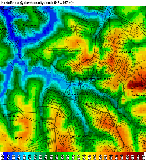
Below is the Elevation map of Hortolândia, which displays elevation range with different colors. Scale of the first map is from 547 to 667 m (1795 to 2188 ft) with average elevation of 599.2 meters (=1966 ft) [note 1]
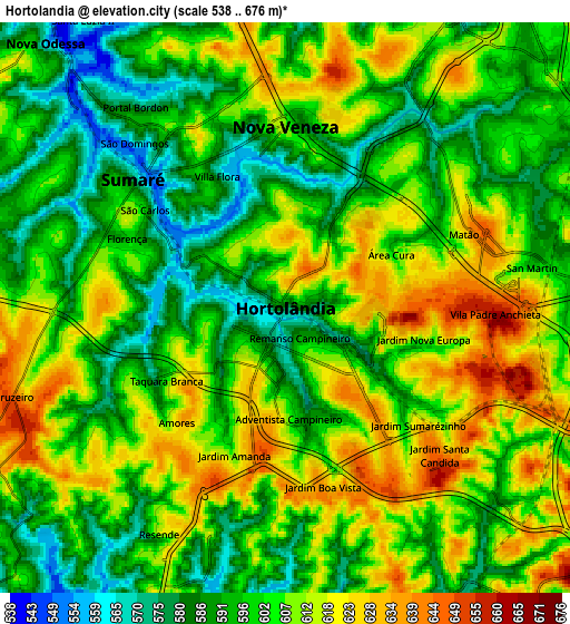
These maps also provides idea of topography and contour of this city, they are displayed at different zoom levels. More info about maps, scale and edge coordinates you can find below images.
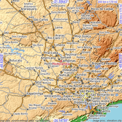
| \ | Map #1 | Map #2 | Topo.Map |
| Scale [m] | 547..667 m | 538..676 m | × |
| Scale [ft] | 1795..2188 ft | 1765..2218 ft | × |
| Average | 599.2 m = 1966 ft | 602.7 m = 1977 ft | × |
| Width | 9.01 km = 5.6 mi | 18.01 km = 11.2 mi | 288.1 km = 179 mi |
| Height | 9.01 km = 5.6 mi | 18.01 km = 11.2 mi | 288.2 km = 179.1 mi |
| ↑Max Latitude | -22.81783° | -22.777317° | -21.55643° |
| Latitude at center | -22.85833° | -22.85833° | -22.85833° |
| ↓Min Latitude | -22.898818° | -22.939294° | -24.14788° |
| ← Min Longitude | -47.263945° | -47.307891° | -48.62625° |
| Longitude center | -47.22° | -47.22° | -47.22° |
| →Max Longitude | -47.176055° | -47.132109° | -45.81375° |
Nearby cities:
Cities around Hortolândia sort by population:
• Campinas elevation 686 m
17.1 km,  107°
107°
• Sumaré 573 m
6.3 km,  310°
310°
• Americana 563 m
17.5 km,  319°
319°
• Santa Bárbara d'Oeste 565 m
23 km,  300°
300°
• Indaiatuba 630 m
25.6 km,  178°
178°
• Valinhos 684 m
26.1 km,  118°
118°
• Paulínia 588 m
12.7 km,  31°
31°
• Nova Odessa 569 m
11.9 km, 319°
• Cosmópolis 583 m
23.8 km,  5°
5°
• Monte Mor 561 m
13.9 km,  224°
224°
• Jaguariúna 593 m
29.4 km,  54°
54°
• Elias Fausto 579 m
25.9 km, 217°
Multilingual:
 En español:
Hortolândia elevación 584 m.
 En France:
Hortolândia élévation 584 m.
 Auf Deutsch:
Hortolândia höhe über dem Meeresspiegel ist 584 m.

Sources and notes:
- [note 1] Map square and city borders are not equal. Map elevation data is calculated only from area inside that square.
- [src 1] Elevation data from geonames database provided with same terms of usage.
- [src 2] The elevation map of Hortolândia is generated using elevation data from NASA's 3 arcsec (90m) resolution SRTM data.
- [src 3] Base (background) map © OpenStreetMap contributors tiles are generated by Geofabrik and OpenTopoMap.
Copyright & License:
This Hortolândia Elevation Map is licensed under CC BY-SA. You may reuse any part from this page, if you give a proper credit by linking to this URL:
 More info on terms of use page.