Indaiatuba elevation
Indaiatuba (São Paulo), Brazil elevation is 630 meters and Indaiatuba elevation in feet is 2067 ft above sea level [src 1]. Indaiatuba is a seat of a second-order administrative division (feature code) with elevation that is 248 meters (814 ft) bigger than average city elevation in Brazil.
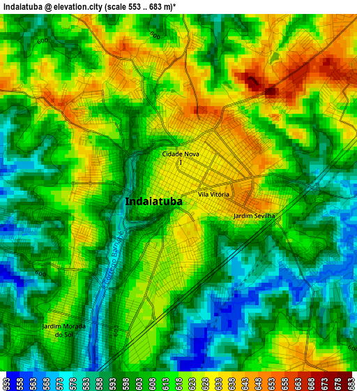
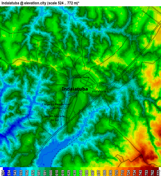
Below is the Elevation map of Indaiatuba, which displays elevation range with different colors. Scale of the first map is from 553 to 683 m (1814 to 2241 ft) with average elevation of 609.9 meters (=2001 ft) [note 1]
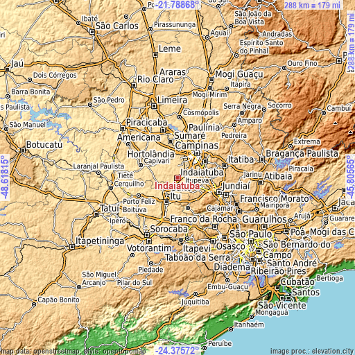
These maps also provides idea of topography and contour of this city, they are displayed at different zoom levels. More info about maps, scale and edge coordinates you can find below images.
| \ | Map #1 | Map #2 | Topo.Map |
| Scale [m] | 553..683 m | 524..772 m | × |
| Scale [ft] | 1814..2241 ft | 1719..2533 ft | × |
| Average | 609.9 m = 2001 ft | 612.6 m = 2010 ft | × |
| Width | 8.99 km = 5.6 mi | 17.98 km = 11.2 mi | 287.7 km = 178.8 mi |
| Height | 8.99 km = 5.6 mi | 17.98 km = 11.2 mi | 287.7 km = 178.8 mi |
| ↑Max Latitude | -23.047989° | -23.007545° | -21.78868° |
| Latitude at center | -23.08842° | -23.08842° | -23.08842° |
| ↓Min Latitude | -23.128839° | -23.169246° | -24.37572° |
| ← Min Longitude | -47.255845° | -47.299791° | -48.61815° |
| Longitude center | -47.2119° | -47.2119° | -47.2119° |
| →Max Longitude | -47.167955° | -47.124009° | -45.80565° |
Nearby cities:
Cities around Indaiatuba sort by population:
• Campinas elevation 686 m
25.5 km,  37°
37°
• Sumaré 573 m
30.2 km,  349°
349°
• Hortolândia 584 m
25.6 km,  358°
358°
• Itu 594 m
21.5 km,  204°
204°
• Salto 562 m
14.7 km,  211°
211°
• Valinhos 684 m
25.7 km,  59°
59°
• Vinhedo 733 m
25.1 km,  74°
74°
• Monte Mor 561 m
19 km,  325°
325°
• Cabreúva 638 m
25.7 km,  161°
161°
• Louveira 702 m
26.7 km,  89°
89°
• Itupeva 676 m
17.3 km,  114°
114°
• Elias Fausto 579 m
17.3 km,  287°
287°
Multilingual:
 En español:
Indaiatuba elevación 630 m.
 En France:
Indaiatuba élévation 630 m.
 Auf Deutsch:
Indaiatuba höhe über dem Meeresspiegel ist 630 m.

Sources and notes:
- [note 1] Map square and city borders are not equal. Map elevation data is calculated only from area inside that square.
- [src 1] Elevation data from geonames database provided with same terms of usage.
- [src 2] The elevation map of Indaiatuba is generated using elevation data from NASA's 3 arcsec (90m) resolution SRTM data.
- [src 3] Base (background) map © OpenStreetMap contributors tiles are generated by Geofabrik and OpenTopoMap.
Copyright & License:
This Indaiatuba Elevation Map is licensed under CC BY-SA. You may reuse any part from this page, if you give a proper credit by linking to this URL:
 More info on terms of use page.