Itu elevation
Itu (São Paulo), Brazil elevation is 594 meters and Itu elevation in feet is 1949 ft above sea level [src 1]. Itu is a populated place (feature code) with elevation that is 212 meters (696 ft) bigger than average city elevation in Brazil.
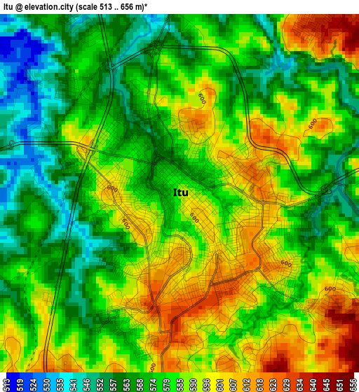
Below is the Elevation map of Itu, which displays elevation range with different colors. Scale of the first map is from 513 to 656 m (1683 to 2152 ft) with average elevation of 580.7 meters (=1905 ft) [note 1]
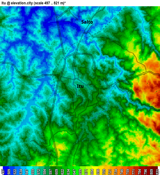
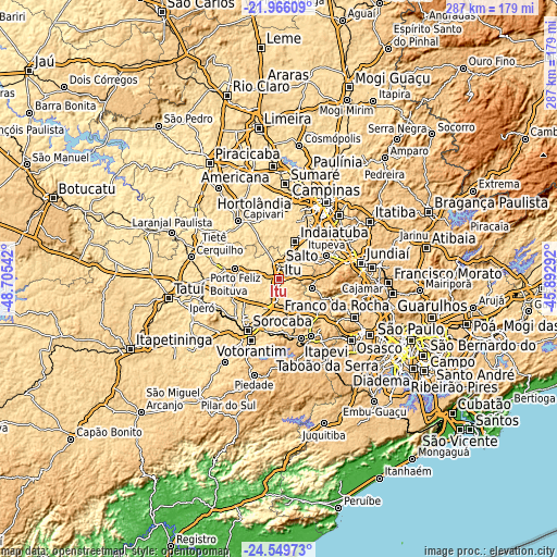
These maps also provides idea of topography and contour of this city, they are displayed at different zoom levels. More info about maps, scale and edge coordinates you can find below images.
| \ | Map #1 | Map #2 | Topo.Map |
| Scale [m] | 513..656 m | 497..821 m | × |
| Scale [ft] | 1683..2152 ft | 1631..2694 ft | × |
| Average | 580.7 m = 1905 ft | 596.3 m = 1956 ft | × |
| Width | 8.98 km = 5.6 mi | 17.96 km = 11.2 mi | 287.3 km = 178.5 mi |
| Height | 8.98 km = 5.6 mi | 17.96 km = 11.2 mi | 287.3 km = 178.5 mi |
| ↑Max Latitude | -23.223792° | -23.183401° | -21.96609° |
| Latitude at center | -23.26417° | -23.26417° | -23.26417° |
| ↓Min Latitude | -23.304536° | -23.34489° | -24.54973° |
| ← Min Longitude | -47.343115° | -47.387061° | -48.70542° |
| Longitude center | -47.29917° | -47.29917° | -47.29917° |
| →Max Longitude | -47.255225° | -47.211279° | -45.89292° |
Nearby cities:
Cities around Itu sort by population:
• Sorocaba elevation 602 m
31 km,  211°
211°
• Indaiatuba 630 m
21.5 km,  24°
24°
• Votorantim 572 m
34.4 km,  204°
204°
• Salto 562 m
7.2 km,  10°
10°
• São Roque 773 m
33.9 km,  150°
150°
• Mairinque 850 m
33.5 km,  159°
159°
• Porto Feliz 541 m
23.6 km,  283°
283°
• Monte Mor 561 m
35.3 km,  357°
357°
• Cabreúva 638 m
17.7 km,  105°
105°
• Itupeva 676 m
27.6 km,  63°
63°
• Pirapora do Bom Jesus 678 m
33.7 km,  115°
115°
• Elias Fausto 579 m
25.8 km,  342°
342°
Multilingual:
 En español:
Itu elevación 594 m.
 En France:
Itu élévation 594 m.


Sources and notes:
- [note 1] Map square and city borders are not equal. Map elevation data is calculated only from area inside that square.
- [src 1] Elevation data from geonames database provided with same terms of usage.
- [src 2] The elevation map of Itu is generated using elevation data from NASA's 3 arcsec (90m) resolution SRTM data.
- [src 3] Base (background) map © OpenStreetMap contributors tiles are generated by Geofabrik and OpenTopoMap.
Copyright & License:
This Itu Elevation Map is licensed under CC BY-SA. You may reuse any part from this page, if you give a proper credit by linking to this URL:
 More info on terms of use page.