Jaguariúna elevation
Jaguariúna (São Paulo), Brazil elevation is 593 meters and Jaguariúna elevation in feet is 1946 ft above sea level [src 1]. Jaguariúna is a seat of a second-order administrative division (feature code) with elevation that is 211 meters (692 ft) bigger than average city elevation in Brazil.
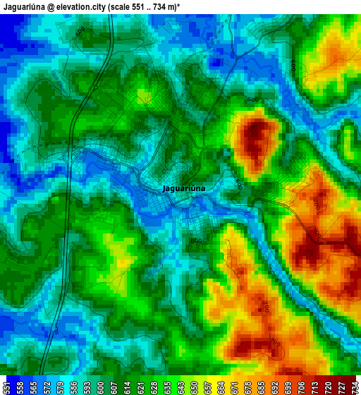
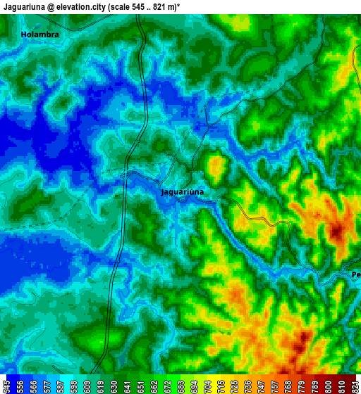
Below is the Elevation map of Jaguariúna, which displays elevation range with different colors. Scale of the first map is from 551 to 734 m (1808 to 2408 ft) with average elevation of 615.9 meters (=2021 ft) [note 1]
These maps also provides idea of topography and contour of this city, they are displayed at different zoom levels. More info about maps, scale and edge coordinates you can find below images.
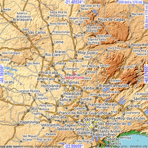
| \ | Map #1 | Map #2 | Topo.Map |
| Scale [m] | 551..734 m | 545..821 m | × |
| Scale [ft] | 1808..2408 ft | 1788..2694 ft | × |
| Average | 615.9 m = 2021 ft | 625.7 m = 2053 ft | × |
| Width | 9.02 km = 5.6 mi | 18.03 km = 11.2 mi | 288.5 km = 179.3 mi |
| Height | 9.02 km = 5.6 mi | 18.03 km = 11.2 mi | 288.5 km = 179.3 mi |
| ↑Max Latitude | -22.665014° | -22.624457° | -21.40224° |
| Latitude at center | -22.70556° | -22.70556° | -22.70556° |
| ↓Min Latitude | -22.746094° | -22.786615° | -23.99659° |
| ← Min Longitude | -47.029775° | -47.073721° | -48.39208° |
| Longitude center | -46.98583° | -46.98583° | -46.98583° |
| →Max Longitude | -46.941885° | -46.897939° | -45.57958° |
Nearby cities:
Cities around Jaguariúna sort by population:
• Campinas elevation 686 m
23.5 km,  199°
199°
• Sumaré 573 m
31.6 km,  245°
245°
• Hortolândia 584 m
29.4 km,  234°
234°
• Valinhos 684 m
29.5 km,  181°
181°
• Mogi Mirim 631 m
30.6 km,  5°
5°
• Paulínia 588 m
18.3 km, 250°
• Cosmópolis 583 m
22.6 km,  287°
287°
• Amparo 680 m
22.7 km,  88°
88°
• Artur Nogueira 647 m
24.2 km,  307°
307°
• Pedreira 601 m
9.6 km,  115°
115°
• Serra Negra 937 m
31.1 km,  70°
70°
• Santo Antônio de Posse 669 m
13 km,  31°
31°
Multilingual:
 En español:
Jaguariúna elevación 593 m.
 En France:
Jaguariúna élévation 593 m.
 Auf Deutsch:
Jaguariúna höhe über dem Meeresspiegel ist 593 m.

Sources and notes:
- [note 1] Map square and city borders are not equal. Map elevation data is calculated only from area inside that square.
- [src 1] Elevation data from geonames database provided with same terms of usage.
- [src 2] The elevation map of Jaguariúna is generated using elevation data from NASA's 3 arcsec (90m) resolution SRTM data.
- [src 3] Base (background) map © OpenStreetMap contributors tiles are generated by Geofabrik and OpenTopoMap.
Copyright & License:
This Jaguariúna Elevation Map is licensed under CC BY-SA. You may reuse any part from this page, if you give a proper credit by linking to this URL:
 More info on terms of use page.