Amparo elevation
Amparo (São Paulo), Brazil elevation is 680 meters and Amparo elevation in feet is 2231 ft above sea level [src 1]. Amparo is a seat of a second-order administrative division (feature code) with elevation that is 298 meters (978 ft) bigger than average city elevation in Brazil.
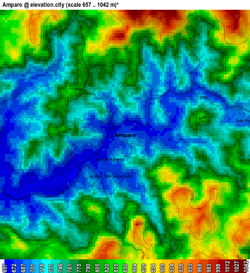
Below is the Elevation map of Amparo, which displays elevation range with different colors. Scale of the first map is from 657 to 1042 m (2156 to 3419 ft) with average elevation of 776.9 meters (=2549 ft) [note 1]
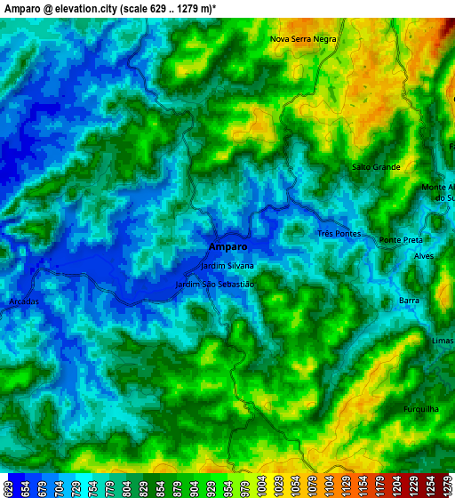
These maps also provides idea of topography and contour of this city, they are displayed at different zoom levels. More info about maps, scale and edge coordinates you can find below images.
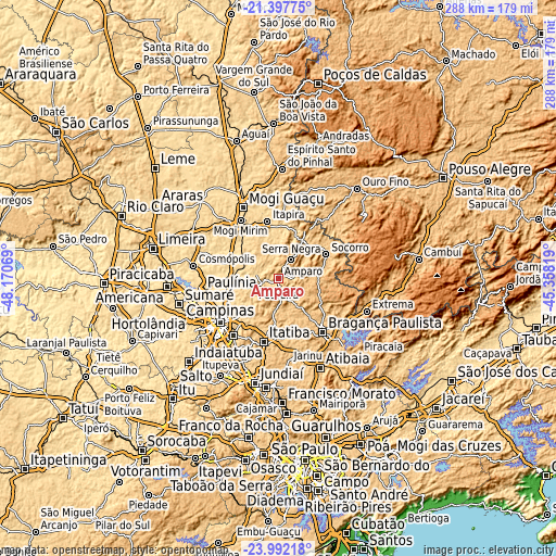
| \ | Map #1 | Map #2 | Topo.Map |
| Scale [m] | 657..1042 m | 629..1279 m | × |
| Scale [ft] | 2156..3419 ft | 2064..4196 ft | × |
| Average | 776.9 m = 2549 ft | 827.7 m = 2716 ft | × |
| Width | 9.02 km = 5.6 mi | 18.03 km = 11.2 mi | 288.5 km = 179.3 mi |
| Height | 9.02 km = 5.6 mi | 18.03 km = 11.2 mi | 288.5 km = 179.3 mi |
| ↑Max Latitude | -22.660563° | -22.620004° | -21.39775° |
| Latitude at center | -22.70111° | -22.70111° | -22.70111° |
| ↓Min Latitude | -22.741645° | -22.782168° | -23.99218° |
| ← Min Longitude | -46.808385° | -46.852331° | -48.17069° |
| Longitude center | -46.76444° | -46.76444° | -46.76444° |
| →Max Longitude | -46.720495° | -46.676549° | -45.35819° |
Nearby cities:
Cities around Amparo sort by population:
• Campinas elevation 686 m
37.9 km,  233°
233°
• Bragança Paulista 831 m
35.9 km,  141°
141°
• Mogi Mirim 631 m
35.9 km,  326°
326°
• Itatiba 782 m
34.7 km,  192°
192°
• Itapira 649 m
30 km,  348°
348°
• Pedreira 601 m
14.8 km,  252°
252°
• Jaguariúna 593 m
22.7 km,  268°
268°
• Socorro 766 m
27.1 km,  63°
63°
• Serra Negra 937 m
11.9 km,  33°
33°
• Águas de Lindóia 901 m
28.4 km, 28°
• Santo Antônio de Posse 669 m
19.1 km,  303°
303°
• Monte Sião 857 m
35.8 km, 33°
Multilingual:
 En español:
Amparo elevación 680 m.
 En France:
Amparo élévation 680 m.


Sources and notes:
- [note 1] Map square and city borders are not equal. Map elevation data is calculated only from area inside that square.
- [src 1] Elevation data from geonames database provided with same terms of usage.
- [src 2] The elevation map of Amparo is generated using elevation data from NASA's 3 arcsec (90m) resolution SRTM data.
- [src 3] Base (background) map © OpenStreetMap contributors tiles are generated by Geofabrik and OpenTopoMap.
Copyright & License:
This Amparo Elevation Map is licensed under CC BY-SA. You may reuse any part from this page, if you give a proper credit by linking to this URL:
 More info on terms of use page.