Ibiá elevation
Ibiá (Minas Gerais), Brazil elevation is 894 meters and Ibiá elevation in feet is 2933 ft above sea level [src 1]. Ibiá is a populated place (feature code) with elevation that is 512 meters (1680 ft) bigger than average city elevation in Brazil.
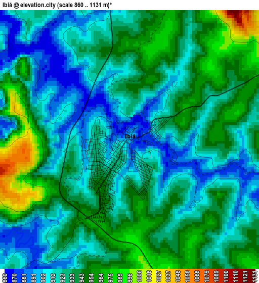
Below is the Elevation map of Ibiá, which displays elevation range with different colors. Scale of the first map is from 860 to 1131 m (2822 to 3711 ft) with average elevation of 931.2 meters (=3055 ft) [note 1]
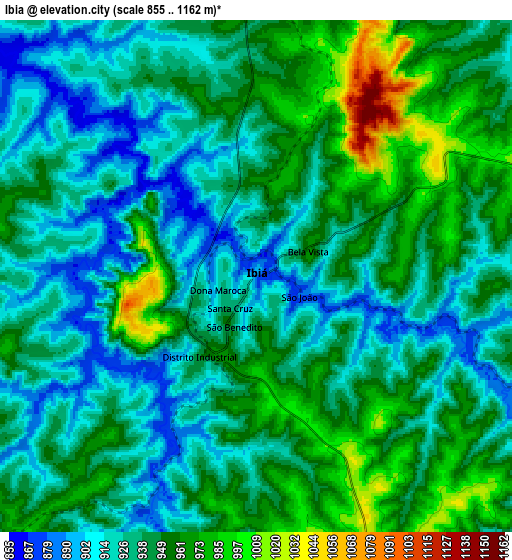
These maps also provides idea of topography and contour of this city, they are displayed at different zoom levels. More info about maps, scale and edge coordinates you can find below images.
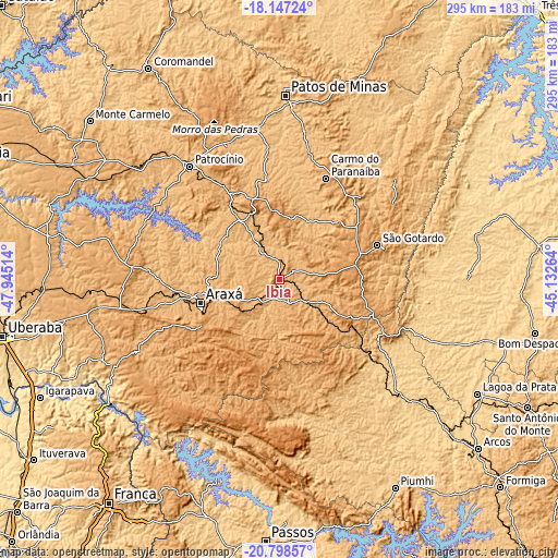
| \ | Map #1 | Map #2 | Topo.Map |
| Scale [m] | 860..1131 m | 855..1162 m | × |
| Scale [ft] | 2822..3711 ft | 2805..3812 ft | × |
| Average | 931.2 m = 3055 ft | 941 m = 3087 ft | × |
| Width | 9.21 km = 5.7 mi | 18.43 km = 11.5 mi | 294.8 km = 183.2 mi |
| Height | 9.21 km = 5.7 mi | 18.43 km = 11.5 mi | 294.8 km = 183.2 mi |
| ↑Max Latitude | -19.436894° | -19.395448° | -18.14724° |
| Latitude at center | -19.47833° | -19.47833° | -19.47833° |
| ↓Min Latitude | -19.519755° | -19.561169° | -20.79857° |
| ← Min Longitude | -46.582835° | -46.626781° | -47.94514° |
| Longitude center | -46.53889° | -46.53889° | -46.53889° |
| →Max Longitude | -46.494945° | -46.450999° | -45.13264° |
Nearby cities:
Cities around Ibiá sort by population:
• Patos de Minas elevation 842 m
100 km,  1°
1°
• Araxá 1002 m
44 km,  253°
253°
• Patrocínio 965 m
76.2 km,  321°
321°
• São Gotardo 1063 m
54.7 km,  70°
70°
• Carmo do Paranaíba 1069 m
58 km,  23°
23°
• Bambuí 700 m
83.1 km,  134°
134°
• Sacramento 841 m
103.7 km, 245°
• Luz 679 m
96.3 km,  111°
111°
• Presidente Olegário 960 m
118.6 km,  6°
6°
• Dores do Indaiá 723 m
98.3 km,  89°
89°
• Campos Altos 1042 m
45.5 km,  122°
122°
• Lagoa Formosa 878 m
79 km, 10°
Multilingual:
 En español:
Ibiá elevación 894 m.
 En France:
Ibiá élévation 894 m.


Sources and notes:
- [note 1] Map square and city borders are not equal. Map elevation data is calculated only from area inside that square.
- [src 1] Elevation data from geonames database provided with same terms of usage.
- [src 2] The elevation map of Ibiá is generated using elevation data from NASA's 3 arcsec (90m) resolution SRTM data.
- [src 3] Base (background) map © OpenStreetMap contributors tiles are generated by Geofabrik and OpenTopoMap.
Copyright & License:
This Ibiá Elevation Map is licensed under CC BY-SA. You may reuse any part from this page, if you give a proper credit by linking to this URL:
 More info on terms of use page.