Luz elevation
Luz (Minas Gerais), Brazil elevation is 679 meters and Luz elevation in feet is 2228 ft above sea level [src 1]. Luz is a populated place (feature code) with elevation that is 297 meters (974 ft) bigger than average city elevation in Brazil.
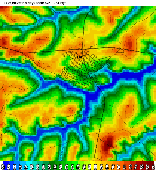
Below is the Elevation map of Luz, which displays elevation range with different colors. Scale of the first map is from 625 to 731 m (2051 to 2398 ft) with average elevation of 674.1 meters (=2212 ft) [note 1]
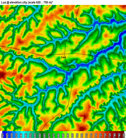
These maps also provides idea of topography and contour of this city, they are displayed at different zoom levels. More info about maps, scale and edge coordinates you can find below images.
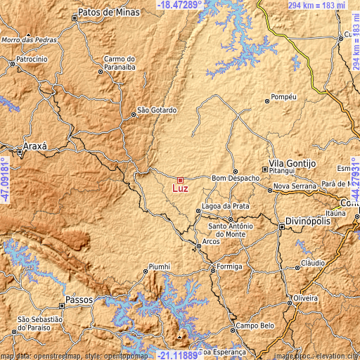
| \ | Map #1 | Map #2 | Topo.Map |
| Scale [m] | 625..731 m | 620..750 m | × |
| Scale [ft] | 2051..2398 ft | 2034..2461 ft | × |
| Average | 674.1 m = 2212 ft | 679.5 m = 2229 ft | × |
| Width | 9.19 km = 5.7 mi | 18.39 km = 11.4 mi | 294.2 km = 182.8 mi |
| Height | 9.19 km = 5.7 mi | 18.39 km = 11.4 mi | 294.2 km = 182.8 mi |
| ↑Max Latitude | -19.760038° | -19.718675° | -18.47289° |
| Latitude at center | -19.80139° | -19.80139° | -19.80139° |
| ↓Min Latitude | -19.842732° | -19.884062° | -21.11889° |
| ← Min Longitude | -45.729505° | -45.773451° | -47.09181° |
| Longitude center | -45.68556° | -45.68556° | -45.68556° |
| →Max Longitude | -45.641615° | -45.597669° | -44.27931° |
Nearby cities:
Cities around Luz sort by population:
• Formiga elevation 841 m
78.5 km,  159°
159°
• Lagoa da Prata 662 m
28.7 km,  148°
148°
• Bom Despacho 771 m
45.9 km,  80°
80°
• São Gotardo 1063 m
66.5 km,  325°
325°
• Arcos 737 m
55.6 km, 164°
• Piuí 791 m
79.1 km,  201°
201°
• Santo Antônio do Monte 938 m
51.8 km,  127°
127°
• Abaeté 639 m
75.6 km,  19°
19°
• Bambuí 700 m
38 km,  233°
233°
• Dores do Indaiá 723 m
38.6 km,  13°
13°
• Campos Altos 1042 m
52.2 km,  282°
282°
• Martinho Campos 679 m
70.3 km,  41°
41°
Multilingual:
 En español:
Luz elevación 679 m.
 En France:
Luz élévation 679 m.


Sources and notes:
- [note 1] Map square and city borders are not equal. Map elevation data is calculated only from area inside that square.
- [src 1] Elevation data from geonames database provided with same terms of usage.
- [src 2] The elevation map of Luz is generated using elevation data from NASA's 3 arcsec (90m) resolution SRTM data.
- [src 3] Base (background) map © OpenStreetMap contributors tiles are generated by Geofabrik and OpenTopoMap.
Copyright & License:
This Luz Elevation Map is licensed under CC BY-SA. You may reuse any part from this page, if you give a proper credit by linking to this URL:
 More info on terms of use page.