São Gotardo elevation
São Gotardo (Minas Gerais), Brazil elevation is 1063 meters and São Gotardo elevation in feet is 3488 ft above sea level [src 1]. São Gotardo is a populated place (feature code) with elevation that is 681 meters (2234 ft) bigger than average city elevation in Brazil.
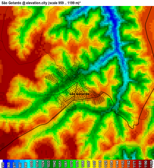
Below is the Elevation map of São Gotardo, which displays elevation range with different colors. Scale of the first map is from 959 to 1199 m (3146 to 3934 ft) with average elevation of 1102.5 meters (=3617 ft) [note 1]
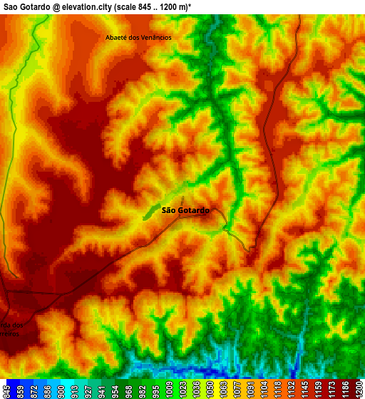
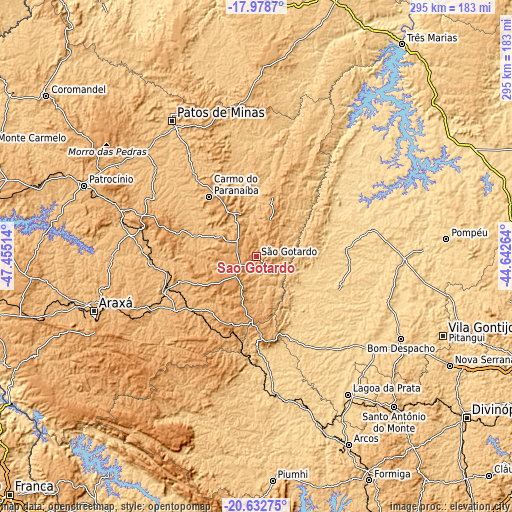
These maps also provides idea of topography and contour of this city, they are displayed at different zoom levels. More info about maps, scale and edge coordinates you can find below images.
| \ | Map #1 | Map #2 | Topo.Map |
| Scale [m] | 959..1199 m | 845..1200 m | × |
| Scale [ft] | 3146..3934 ft | 2772..3937 ft | × |
| Average | 1102.5 m = 3617 ft | 1080.9 m = 3546 ft | × |
| Width | 9.22 km = 5.7 mi | 18.45 km = 11.5 mi | 295.1 km = 183.4 mi |
| Height | 9.22 km = 5.7 mi | 18.45 km = 11.5 mi | 295.1 km = 183.4 mi |
| ↑Max Latitude | -19.269632° | -19.228143° | -17.9787° |
| Latitude at center | -19.31111° | -19.31111° | -19.31111° |
| ↓Min Latitude | -19.352578° | -19.394035° | -20.63275° |
| ← Min Longitude | -46.092835° | -46.136781° | -47.45514° |
| Longitude center | -46.04889° | -46.04889° | -46.04889° |
| →Max Longitude | -46.004945° | -45.960999° | -44.64264° |
Nearby cities:
Cities around São Gotardo sort by population:
• Patos de Minas elevation 842 m
95.2 km,  328°
328°
• Lagoa da Prata 662 m
95.2 km,  146°
146°
• Bom Despacho 771 m
95.9 km,  119°
119°
• Carmo do Paranaíba 1069 m
44.5 km,  320°
320°
• Abaeté 639 m
65.5 km,  75°
75°
• Bambuí 700 m
77.7 km,  174°
174°
• Ibiá 894 m
54.7 km,  250°
250°
• Luz 679 m
66.5 km, 145°
• Dores do Indaiá 723 m
49.9 km,  109°
109°
• Campos Altos 1042 m
44.7 km,  196°
196°
• Lagoa Formosa 878 m
70.2 km, 327°
• Martinho Campos 679 m
85.2 km,  91°
91°
Multilingual:
 En español:
São Gotardo elevación 1063 m.
 En France:
São Gotardo élévation 1063 m.
 Auf Deutsch:
São Gotardo höhe über dem Meeresspiegel ist 1063 m.

Sources and notes:
- [note 1] Map square and city borders are not equal. Map elevation data is calculated only from area inside that square.
- [src 1] Elevation data from geonames database provided with same terms of usage.
- [src 2] The elevation map of São Gotardo is generated using elevation data from NASA's 3 arcsec (90m) resolution SRTM data.
- [src 3] Base (background) map © OpenStreetMap contributors tiles are generated by Geofabrik and OpenTopoMap.
Copyright & License:
This São Gotardo Elevation Map is licensed under CC BY-SA. You may reuse any part from this page, if you give a proper credit by linking to this URL:
 More info on terms of use page.