Itabaiana elevation
Itabaiana (Sergipe), Brazil elevation is 190 meters and Itabaiana elevation in feet is 623 ft above sea level [src 1]. Itabaiana is a populated place (feature code) with elevation that is 192 meters (630 ft) smaller than average city elevation in Brazil.
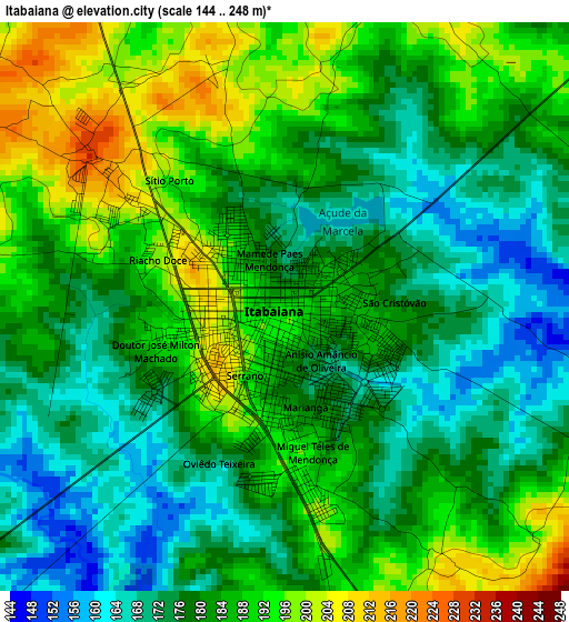
Below is the Elevation map of Itabaiana, which displays elevation range with different colors. Scale of the first map is from 144 to 248 m (472 to 814 ft) with average elevation of 182 meters (=597 ft) [note 1]
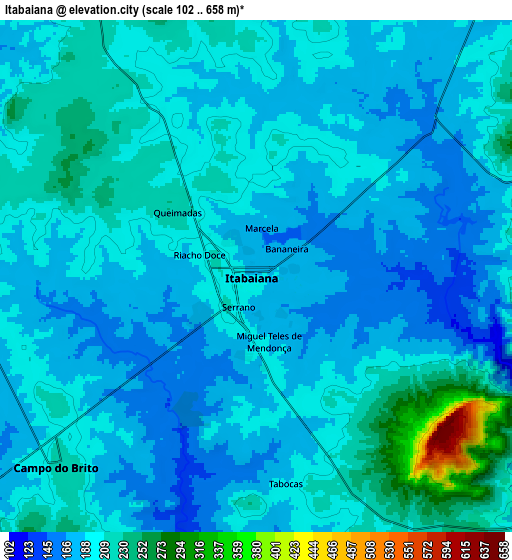
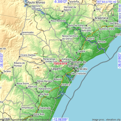
These maps also provides idea of topography and contour of this city, they are displayed at different zoom levels. More info about maps, scale and edge coordinates you can find below images.
| \ | Map #1 | Map #2 | Topo.Map |
| Scale [m] | 144..248 m | 102..658 m | × |
| Scale [ft] | 472..814 ft | 335..2159 ft | × |
| Average | 182 m = 597 ft | 196.9 m = 646 ft | × |
| Width | 9.6 km = 6 mi | 19.21 km = 11.9 mi | 307.3 km = 190.9 mi |
| Height | 9.6 km = 6 mi | 19.21 km = 11.9 mi | 307.3 km = 190.9 mi |
| ↑Max Latitude | -10.641814° | -10.598621° | -9.30012° |
| Latitude at center | -10.685° | -10.685° | -10.685° |
| ↓Min Latitude | -10.72818° | -10.771354° | -12.06359° |
| ← Min Longitude | -37.469225° | -37.513171° | -38.83153° |
| Longitude center | -37.42528° | -37.42528° | -37.42528° |
| →Max Longitude | -37.381335° | -37.337389° | -36.01903° |
Nearby cities:
Cities around Itabaiana sort by population:
• Nossa Senhora do Socorro elevation 39 m
37.8 km,  120°
120°
• Lagarto 138 m
35.6 km,  223°
223°
• Laranjeiras 49 m
31 km, 115°
• Nossa Senhora das Dores 201 m
33.2 km,  49°
49°
• Maruim 12 m
38 km,  98°
98°
• Ribeirópolis 239 m
16.2 km,  3°
3°
• Campo do Brito 207 m
9.2 km,  234°
234°
• Areia Branca 163 m
14.5 km, 123°
• Frei Paulo 276 m
19.2 km,  321°
321°
• Malhador 263 m
13.5 km,  77°
77°
• Salgado 103 m
39 km,  188°
188°
• Moita Bonita 228 m
15 km,  37°
37°
Multilingual:
 En español:
Itabaiana elevación 190 m.
 En France:
Itabaiana élévation 190 m.
 Auf Deutsch:
Itabaiana höhe über dem Meeresspiegel ist 190 m.

Sources and notes:
- [note 1] Map square and city borders are not equal. Map elevation data is calculated only from area inside that square.
- [src 1] Elevation data from geonames database provided with same terms of usage.
- [src 2] The elevation map of Itabaiana is generated using elevation data from NASA's 3 arcsec (90m) resolution SRTM data.
- [src 3] Base (background) map © OpenStreetMap contributors tiles are generated by Geofabrik and OpenTopoMap.
Copyright & License:
This Itabaiana Elevation Map is licensed under CC BY-SA. You may reuse any part from this page, if you give a proper credit by linking to this URL:
 More info on terms of use page.