Lagarto elevation
Lagarto (Sergipe), Brazil elevation is 138 meters and Lagarto elevation in feet is 453 ft above sea level [src 1]. Lagarto is a populated place (feature code) with elevation that is 244 meters (801 ft) smaller than average city elevation in Brazil.
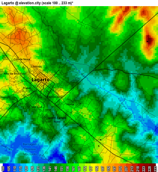
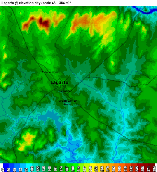
Below is the Elevation map of Lagarto, which displays elevation range with different colors. Scale of the first map is from 100 to 233 m (328 to 764 ft) with average elevation of 153 meters (=502 ft) [note 1]
These maps also provides idea of topography and contour of this city, they are displayed at different zoom levels. More info about maps, scale and edge coordinates you can find below images.
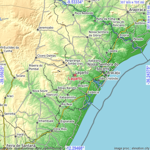
| \ | Map #1 | Map #2 | Topo.Map |
| Scale [m] | 100..233 m | 43..384 m | × |
| Scale [ft] | 328..764 ft | 141..1260 ft | × |
| Average | 153 m = 502 ft | 160.1 m = 525 ft | × |
| Width | 9.6 km = 6 mi | 19.19 km = 11.9 mi | 307 km = 190.8 mi |
| Height | 9.6 km = 6 mi | 19.19 km = 11.9 mi | 307.1 km = 190.8 mi |
| ↑Max Latitude | -10.874067° | -10.830908° | -9.53334° |
| Latitude at center | -10.91722° | -10.91722° | -10.91722° |
| ↓Min Latitude | -10.960367° | -11.003507° | -12.29468° |
| ← Min Longitude | -37.693945° | -37.737891° | -39.05625° |
| Longitude center | -37.65° | -37.65° | -37.65° |
| →Max Longitude | -37.606055° | -37.562109° | -36.24375° |
Nearby cities:
Cities around Lagarto sort by population:
• Itabaiana elevation 190 m
35.6 km,  43°
43°
• Estância 54 m
45.4 km,  149°
149°
• Simão Dias 265 m
26.6 km,  318°
318°
• Itabaianinha 223 m
42.5 km,  201°
201°
• Boquim 162 m
25.7 km,  172°
172°
• Campo do Brito 207 m
26.7 km, 39°
• Areia Branca 163 m
40.6 km,  64°
64°
• Frei Paulo 276 m
42.8 km,  17°
17°
• Paripiranga 439 m
34.5 km, 317°
• Salgado 103 m
23 km,  123°
123°
• Arauá 112 m
38.5 km,  175°
175°
• Riachão do Dantas 179 m
18.7 km,  205°
205°
Multilingual:
 En español:
Lagarto elevación 138 m.
 En France:
Lagarto élévation 138 m.


Sources and notes:
- [note 1] Map square and city borders are not equal. Map elevation data is calculated only from area inside that square.
- [src 1] Elevation data from geonames database provided with same terms of usage.
- [src 2] The elevation map of Lagarto is generated using elevation data from NASA's 3 arcsec (90m) resolution SRTM data.
- [src 3] Base (background) map © OpenStreetMap contributors tiles are generated by Geofabrik and OpenTopoMap.
Copyright & License:
This Lagarto Elevation Map is licensed under CC BY-SA. You may reuse any part from this page, if you give a proper credit by linking to this URL:
 More info on terms of use page.