Simão Dias elevation
Simão Dias (Sergipe), Brazil elevation is 265 meters and Simão Dias elevation in feet is 869 ft above sea level [src 1]. Simão Dias is a populated place (feature code) with elevation that is 117 meters (384 ft) smaller than average city elevation in Brazil.
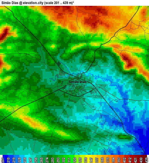
Below is the Elevation map of Simão Dias, which displays elevation range with different colors. Scale of the first map is from 201 to 439 m (659 to 1440 ft) with average elevation of 290.6 meters (=953 ft) [note 1]
These maps also provides idea of topography and contour of this city, they are displayed at different zoom levels. More info about maps, scale and edge coordinates you can find below images.
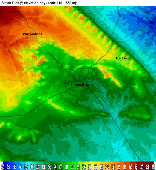
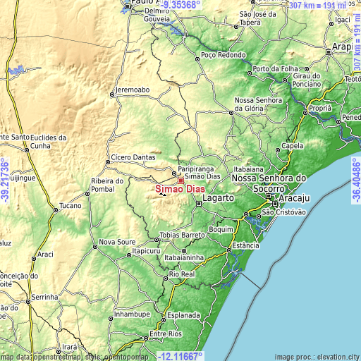
| \ | Map #1 | Map #2 | Topo.Map |
| Scale [m] | 201..439 m | 110..550 m | × |
| Scale [ft] | 659..1440 ft | 361..1804 ft | × |
| Average | 290.6 m = 953 ft | 290.1 m = 952 ft | × |
| Width | 9.6 km = 6 mi | 19.2 km = 11.9 mi | 307.2 km = 190.9 mi |
| Height | 9.6 km = 6 mi | 19.2 km = 11.9 mi | 307.2 km = 190.9 mi |
| ↑Max Latitude | -10.695151° | -10.651966° | -9.35368° |
| Latitude at center | -10.73833° | -10.73833° | -10.73833° |
| ↓Min Latitude | -10.781503° | -10.824669° | -12.11667° |
| ← Min Longitude | -37.855055° | -37.899001° | -39.21736° |
| Longitude center | -37.81111° | -37.81111° | -37.81111° |
| →Max Longitude | -37.767165° | -37.723219° | -36.40486° |
Nearby cities:
Cities around Simão Dias sort by population:
• Itabaiana elevation 190 m
42.6 km,  81°
81°
• Lagarto 138 m
26.6 km,  138°
138°
• Tobias Barreto 164 m
53.6 km,  202°
202°
• Boquim 162 m
50 km,  155°
155°
• Poço Verde 260 m
40.8 km,  274°
274°
• Ribeirópolis 239 m
48.4 km,  62°
62°
• Carira 361 m
43.7 km,  15°
15°
• Campo do Brito 207 m
34.7 km,  89°
89°
• Frei Paulo 276 m
36.8 km, 55°
• Paripiranga 439 m
7.9 km,  315°
315°
• Salgado 103 m
49.1 km,  131°
131°
• Riachão do Dantas 179 m
37.9 km,  165°
165°
Multilingual:
 En español:
Simão Dias elevación 265 m.
 En France:
Simão Dias élévation 265 m.
 Auf Deutsch:
Simão Dias höhe über dem Meeresspiegel ist 265 m.

Sources and notes:
- [note 1] Map square and city borders are not equal. Map elevation data is calculated only from area inside that square.
- [src 1] Elevation data from geonames database provided with same terms of usage.
- [src 2] The elevation map of Simão Dias is generated using elevation data from NASA's 3 arcsec (90m) resolution SRTM data.
- [src 3] Base (background) map © OpenStreetMap contributors tiles are generated by Geofabrik and OpenTopoMap.
Copyright & License:
This Simão Dias Elevation Map is licensed under CC BY-SA. You may reuse any part from this page, if you give a proper credit by linking to this URL:
 More info on terms of use page.