Juquitiba elevation
Juquitiba (São Paulo), Brazil elevation is 691 meters and Juquitiba elevation in feet is 2267 ft above sea level [src 1]. Juquitiba is a populated place (feature code) with elevation that is 309 meters (1014 ft) bigger than average city elevation in Brazil.
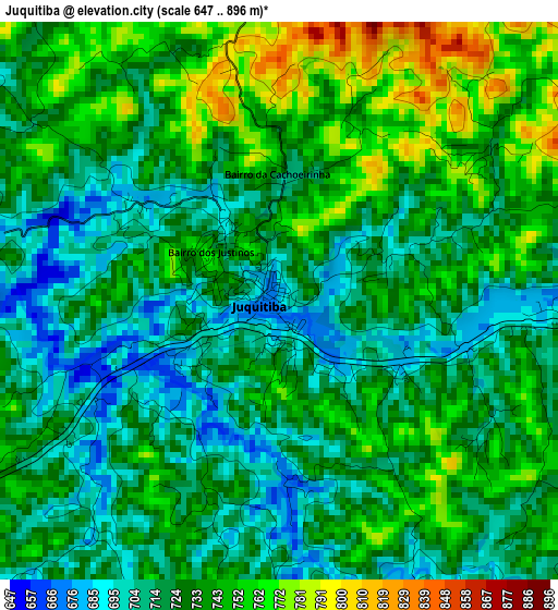
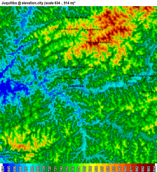
Below is the Elevation map of Juquitiba, which displays elevation range with different colors. Scale of the first map is from 647 to 896 m (2123 to 2940 ft) with average elevation of 729.8 meters (=2394 ft) [note 1]
These maps also provides idea of topography and contour of this city, they are displayed at different zoom levels. More info about maps, scale and edge coordinates you can find below images.
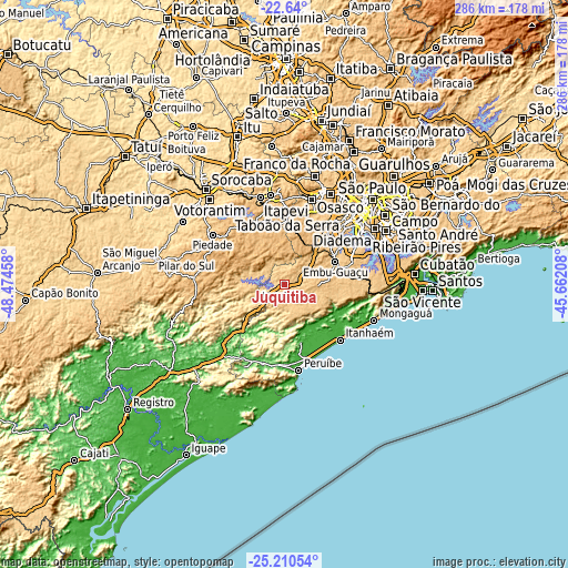
| \ | Map #1 | Map #2 | Topo.Map |
| Scale [m] | 647..896 m | 634..914 m | × |
| Scale [ft] | 2123..2940 ft | 2080..2999 ft | × |
| Average | 729.8 m = 2394 ft | 739.5 m = 2426 ft | × |
| Width | 8.93 km = 5.5 mi | 17.86 km = 11.1 mi | 285.8 km = 177.6 mi |
| Height | 8.93 km = 5.5 mi | 17.86 km = 11.1 mi | 285.8 km = 177.6 mi |
| ↑Max Latitude | -23.891496° | -23.85131° | -22.64° |
| Latitude at center | -23.93167° | -23.93167° | -23.93167° |
| ↓Min Latitude | -23.971831° | -24.01198° | -25.21054° |
| ← Min Longitude | -47.112275° | -47.156221° | -48.47458° |
| Longitude center | -47.06833° | -47.06833° | -47.06833° |
| →Max Longitude | -47.024385° | -46.980439° | -45.66208° |
Nearby cities:
Cities around Juquitiba sort by population:
• Embu elevation 784 m
38.4 km,  34°
34°
• Taboão da Serra 795 m
44.1 km,  39°
39°
• Cotia 801 m
39.5 km,  22°
22°
• Itapecerica da Serra 901 m
32.7 km, 43°
• Itanhaém 12 m
39.8 km,  134°
134°
• Embu Guaçu 766 m
28.4 km,  67°
67°
• Peruíbe 11 m
43.8 km,  170°
170°
• Mairinque 850 m
44.5 km,  344°
344°
• Piedade 795 m
44 km,  303°
303°
• Ibiúna 868 m
34.4 km,  332°
332°
• São Lourenço da Serra 706 m
15.5 km,  55°
55°
• Vargem Grande Paulista 879 m
36.8 km,  6°
6°
Multilingual:
 En español:
Juquitiba elevación 691 m.
 En France:
Juquitiba élévation 691 m.
 Auf Deutsch:
Juquitiba höhe über dem Meeresspiegel ist 691 m.

Sources and notes:
- [note 1] Map square and city borders are not equal. Map elevation data is calculated only from area inside that square.
- [src 1] Elevation data from geonames database provided with same terms of usage.
- [src 2] The elevation map of Juquitiba is generated using elevation data from NASA's 3 arcsec (90m) resolution SRTM data.
- [src 3] Base (background) map © OpenStreetMap contributors tiles are generated by Geofabrik and OpenTopoMap.
Copyright & License:
This Juquitiba Elevation Map is licensed under CC BY-SA. You may reuse any part from this page, if you give a proper credit by linking to this URL:
 More info on terms of use page.