Embu elevation
Embu (São Paulo, Embu das Artes), Brazil elevation is 784 meters and Embu elevation in feet is 2572 ft above sea level [src 1]. Embu is a populated place (feature code) with elevation that is 402 meters (1319 ft) bigger than average city elevation in Brazil.
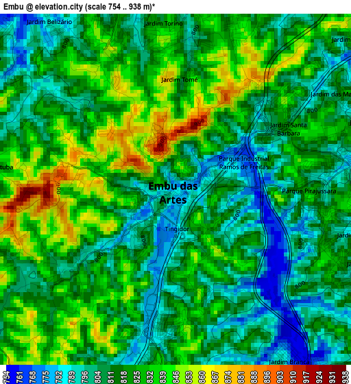
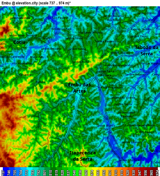
Below is the Elevation map of Embu, which displays elevation range with different colors. Scale of the first map is from 754 to 938 m (2474 to 3077 ft) with average elevation of 818.7 meters (=2686 ft) [note 1]
These maps also provides idea of topography and contour of this city, they are displayed at different zoom levels. More info about maps, scale and edge coordinates you can find below images.
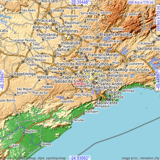
| \ | Map #1 | Map #2 | Topo.Map |
| Scale [m] | 754..938 m | 737..974 m | × |
| Scale [ft] | 2474..3077 ft | 2418..3196 ft | × |
| Average | 818.7 m = 2686 ft | 817.3 m = 2681 ft | × |
| Width | 8.95 km = 5.6 mi | 17.9 km = 11.1 mi | 286.4 km = 178 mi |
| Height | 8.95 km = 5.6 mi | 17.9 km = 11.1 mi | 286.5 km = 178 mi |
| ↑Max Latitude | -23.608629° | -23.568356° | -22.35448° |
| Latitude at center | -23.64889° | -23.64889° | -23.64889° |
| ↓Min Latitude | -23.689139° | -23.729375° | -24.93062° |
| ← Min Longitude | -46.896165° | -46.940111° | -48.25847° |
| Longitude center | -46.85222° | -46.85222° | -46.85222° |
| →Max Longitude | -46.808275° | -46.764329° | -45.44597° |
Nearby cities:
Cities around Embu sort by population:
• Osasco elevation 750 m
14.3 km,  25°
25°
• Carapicuíba 762 m
14.1 km,  7°
7°
• Barueri 729 m
15.6 km,  351°
351°
• Taboão da Serra 795 m
6.7 km,  67°
67°
• Itapevi 772 m
13.9 km,  323°
323°
• Cotia 801 m
8.5 km,  306°
306°
• Itapecerica da Serra 901 m
7.6 km,  177°
177°
• Jandira 733 m
14.4 km,  339°
339°
• Jardim Paulista 629 m
21.2 km,  64°
64°
• Embu Guaçu 766 m
20.8 km,  168°
168°
• Paraíso 633 m
22.1 km, 68°
• Vargem Grande Paulista 879 m
18.5 km,  285°
285°
Multilingual:
 En español:
Embu elevación 784 m.
 En France:
Embu élévation 784 m.


Sources and notes:
- [note 1] Map square and city borders are not equal. Map elevation data is calculated only from area inside that square.
- [src 1] Elevation data from geonames database provided with same terms of usage.
- [src 2] The elevation map of Embu is generated using elevation data from NASA's 3 arcsec (90m) resolution SRTM data.
- [src 3] Base (background) map © OpenStreetMap contributors tiles are generated by Geofabrik and OpenTopoMap.
Copyright & License:
This Embu Elevation Map is licensed under CC BY-SA. You may reuse any part from this page, if you give a proper credit by linking to this URL:
 More info on terms of use page.