Mafra elevation
Mafra (Santa Catarina), Brazil elevation is 806 meters and Mafra elevation in feet is 2644 ft above sea level [src 1]. Mafra is a populated place (feature code) with elevation that is 424 meters (1391 ft) bigger than average city elevation in Brazil.
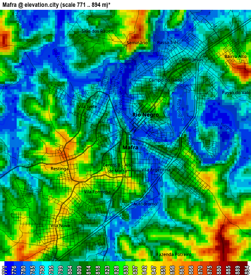
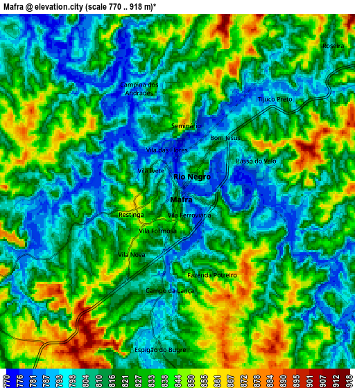
Below is the Elevation map of Mafra, which displays elevation range with different colors. Scale of the first map is from 771 to 894 m (2530 to 2933 ft) with average elevation of 809 meters (=2654 ft) [note 1]
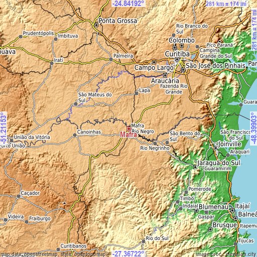
These maps also provides idea of topography and contour of this city, they are displayed at different zoom levels. More info about maps, scale and edge coordinates you can find below images.
| \ | Map #1 | Map #2 | Topo.Map |
| Scale [m] | 771..894 m | 770..918 m | × |
| Scale [ft] | 2530..2933 ft | 2526..3012 ft | × |
| Average | 809 m = 2654 ft | 821.3 m = 2695 ft | × |
| Width | 8.78 km = 5.5 mi | 17.55 km = 10.9 mi | 280.8 km = 174.5 mi |
| Height | 8.78 km = 5.5 mi | 17.55 km = 10.9 mi | 280.8 km = 174.5 mi |
| ↑Max Latitude | -26.071923° | -26.032443° | -24.84192° |
| Latitude at center | -26.11139° | -26.11139° | -26.11139° |
| ↓Min Latitude | -26.150844° | -26.190284° | -27.36722° |
| ← Min Longitude | -49.849225° | -49.893171° | -51.21153° |
| Longitude center | -49.80528° | -49.80528° | -49.80528° |
| →Max Longitude | -49.761335° | -49.717389° | -48.39903° |
Nearby cities:
Cities around Mafra sort by population:
• Araucária elevation 886 m
69.9 km,  34°
34°
• Campo Largo 965 m
77.5 km,  20°
20°
• São Bento do Sul 863 m
45.3 km,  109°
109°
• Rio Negrinho 793 m
32.8 km,  119°
119°
• Canoinhas 779 m
58.8 km,  262°
262°
• Lapa 929 m
39 km,  13°
13°
• São Mateus do Sul 792 m
63.5 km,  294°
294°
• Rio Negro 795 m
1 km,  51°
51°
• Palmeira 913 m
78.5 km,  345°
345°
• Schroeder 46 m
80.3 km, 114°
• Três Barras 767 m
51.6 km,  270°
270°
• Corupá 66 m
66 km, 121°
Multilingual:
 En español:
Mafra elevación 806 m.
 En France:
Mafra élévation 806 m.


Sources and notes:
- [note 1] Map square and city borders are not equal. Map elevation data is calculated only from area inside that square.
- [src 1] Elevation data from geonames database provided with same terms of usage.
- [src 2] The elevation map of Mafra is generated using elevation data from NASA's 3 arcsec (90m) resolution SRTM data.
- [src 3] Base (background) map © OpenStreetMap contributors tiles are generated by Geofabrik and OpenTopoMap.
Copyright & License:
This Mafra Elevation Map is licensed under CC BY-SA. You may reuse any part from this page, if you give a proper credit by linking to this URL:
 More info on terms of use page.